Category:SVG locator maps of 1985-2016 regions in France (dark red location map scheme)
Jump to navigation
Jump to search
Media in category "SVG locator maps of 1985-2016 regions in France (dark red location map scheme)"
The following 22 files are in this category, out of 22 total.
-
 Alsace in France.svg 1,041 × 997; 1.65 MB
-
 Aquitaine in France.svg 1,041 × 997; 1.65 MB
-
 Auvergne in France.svg 1,041 × 997; 1.65 MB
-
 Basse-Normandie in France.svg 1,041 × 997; 1.65 MB
-
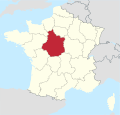
 Bourgogne in France.svg 1,041 × 997; 1.65 MB
-
 Bretagne in France.svg 1,041 × 997; 1.65 MB
-
 Centre-Val de Loire in France.svg 1,041 × 997; 1.65 MB
-
 Champagne-Ardenne in France.svg 1,041 × 997; 1.65 MB
-
 Corse in France.svg 1,041 × 997; 1.65 MB
-
 Franche-Comté in France.svg 1,041 × 997; 1.65 MB
-
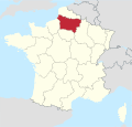
 Haute-Normandie in France.svg 1,041 × 997; 1.65 MB
-
 Île-de-France in France.svg 1,041 × 997; 1.65 MB
-
 Languedoc-Roussillon in France.svg 1,041 × 997; 1.65 MB
-
 Limousin in France.svg 1,041 × 997; 1.65 MB
-
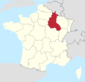
 Lorraine in France.svg 1,041 × 997; 1.65 MB
-
 Midi-Pyrénées in France.svg 1,041 × 997; 1.65 MB
-
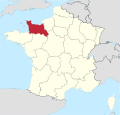
 Nord-Pas-de-Calais in France.svg 1,041 × 997; 1.65 MB
-
 Pays de la Loire in France.svg 1,041 × 997; 1.65 MB
-
 Picardie in France.svg 1,041 × 997; 1.65 MB
-
 Poitou-Charentes in France.svg 1,041 × 997; 1.65 MB
-
 Provence-Alpes-Côte d-Azur in France.svg 1,041 × 997; 1.65 MB
-
 Rhône-Alpes in France.svg 1,041 × 997; 1.65 MB


