Category:Sýlingafell
Jump to navigation
Jump to search
.jpg) | |||||
| Upload media | |||||
| Instance of | |||||
|---|---|---|---|---|---|
| Location | Grindavíkurbær, Southern Peninsula Region, Iceland | ||||
| Elevation above sea level |
| ||||
 | |||||
Subcategories
This category has the following 2 subcategories, out of 2 total.
S
- Slopes of Sýlingafell (1 F)
Media in category "Sýlingafell"
The following 26 files are in this category, out of 26 total.
-
 17-08-04-Blaue-Lagune-RalfR-DSC 2445.jpg 6,000 × 4,000; 13.31 MB
-
 17-08-04-Blaue-Lagune-RalfR-DSC 2450.jpg 3,844 × 5,766; 12.64 MB
-
 17-08-04-Blaue-Lagune-RalfR-DSC 2453.jpg 6,000 × 4,000; 11.77 MB
-
 17-08-04-Blaue-Lagune-RalfR-DSC 2455.jpg 6,000 × 4,000; 11.1 MB
-
 17-12-12-SXF-KEF-RalfR-DSC 2336.jpg 5,690 × 3,793; 8.7 MB
-
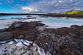
 Aerial view of Grindavík, Hópsnes and mountains.jpg 4,928 × 3,264; 6.07 MB
-
 Aerial view of Hópsnes (Grindavík).jpg 4,928 × 3,264; 5.37 MB
-
 Aerial view of Hópsnes, Húsafell and Hraunsvík.jpg 4,928 × 3,264; 6.35 MB
-
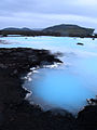
 Blue Lagoon Iceland hdsr 2019 10 19 9999 337.jpg 5,184 × 3,456; 9.37 MB
-
 Blue Lagoon parking lot with mountain Þorbjörn.jpg 4,080 × 3,060; 1.98 MB
-
 Blue lagoon, Iceland - panoramio.jpg 1,600 × 1,200; 866 KB
-
 Blue-Lagoon-Iceland-January-2012.jpg 3,600 × 2,700; 1.54 MB
-
 BlueLagoon (2).jpg 960 × 1,280; 998 KB
-
 BlueLagoonIce10.JPG 3,072 × 2,304; 2.85 MB
-
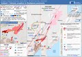 ECDM 20240116 Iceland volcanic(1).pdf 1,625 × 1,125; 577 KB
-
 Grindavik area annotated.jpg 4,096 × 2,713; 2.32 MB
-
 Iceland (3), Reykjanes peninsula.JPG 1,716 × 1,140; 672 KB
-
 Iceland - Blue Lagoon 09 (6571266721).jpg 2,376 × 1,584; 1.02 MB
-
 Iceland Blaa Ionid geothermal IMG 0190.JPG 5,184 × 2,934; 5.57 MB
-
 Iceland Volcano Eruption 19 December 2023.jpg 2,000 × 1,126; 67 KB
-
 Sýlingarfell 2024 (0736).jpg 5,472 × 3,648; 17.93 MB
-
 The Blue Lagoon Iceland Travel Photography (132547081).jpeg 1,200 × 675; 278 KB
-
 View from Þorbjörn, Iceland, 20230430 1519 3646.jpg 5,553 × 3,706; 18.41 MB
-
 View from Þorbjörn, Iceland, 20230430 1521 3649.jpg 5,307 × 3,544; 16.27 MB
-
 View from Þorbjörn, Iceland, 20230430 1532 3660.jpg 5,596 × 3,736; 20.77 MB
-
 Vista aérea del suroeste de Islandia, 2014-08-13, DD 005.JPG 5,502 × 2,833; 5.23 MB


.jpg)


.jpg)


,_Reykjanes_peninsula.JPG)
.jpg)


.jpeg)


