Category:Royal Albert Bridge
Jump to navigation
Jump to search
railway bridge that spans the River Tamar in England | |||||
| Upload media | |||||
| Instance of | |||||
|---|---|---|---|---|---|
| Named after | |||||
| Location |
| ||||
| Bridge number |
| ||||
| Architect | |||||
| Maintained by | |||||
| Crosses | |||||
| Heritage designation |
| ||||
| Inception |
| ||||
| Date of official opening |
| ||||
| Length |
| ||||
| Height |
| ||||
 | |||||
| Cornwall: |
| |
| Devon: |
|
Deutsch: Die Brücke überspannt den Fluss Tamar zwischen Devon und Cornwall im Vereinigten Königreich und trägt die Bahnlinie London-Penzance. Sie wurde von Isambard Kingdom Brunel für die Cornwall-Railway Company entworfen und besteht aus zwei Bögen von je 139 m, 30 m über dem Fluss, und 17 kürzeren Vorlandbrücken. Sie wurde von Prinz Albert von Sachsen-Gotha am 2 Mai 1859 eröffnet, dem Jahr in dem Brunel starb.
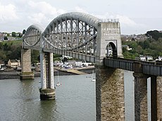
English: The Royal Albert Bridge spans the River Tamar and links Devon and Cornwall in the United Kingdom, carrying the London to Penzance railway line. It was designed by Isambard Kingdom Brunel for the Cornwall Railway Company and consists of two main spans of 455 feet (139 m), 100 feet (30 m) above the river, plus 17 much shorter approach spans. It was opened by Prince Albert on 2 May 1859, the year of Brunel's death.
Français : Ce pont enjambe le fleuve Tamar entre le Devon et les Cornouailles au Royaume-Uni, portant la ligne ferroviaire Londres-Penzance. Il a été conçu par Isambard Kingdom Brunel pour la société des chemins de fer de Cornouailles et se compose de deux envergures principales de 139 m, 30 m au-dessus du fleuve, plus 17 envergures d'approche beaucoup plus courtes. Il a été ouvert par prince Albert d'Angleterre le 2 mai 1859, l'année de la mort de Brunel.
Subcategories
This category has the following 3 subcategories, out of 3 total.
P
S
T
Media in category "Royal Albert Bridge"
The following 197 files are in this category, out of 197 total.
-
Bridges 18.png 976 × 490; 13 KB
-
-1958-09-17 Royal Albert Bridge from Lower Fore Street, Saltash.JPG 2,802 × 4,262; 1.01 MB
-
1854 at the Royal Albert Bridge - sinking the central pier.jpg 649 × 412; 56 KB
-
Royal albert bridge hist.jpg 3,000 × 2,500; 1.47 MB
-
May - Saltash Bridge, Devon, England.jpg 6,405 × 3,195; 17.57 MB
-
Royal Albert Bridge (8767006118).jpg 1,300 × 620; 180 KB
-
Royal Albert Bridge, Saltash (from Saltash).jpg 1,024 × 642; 152 KB
-
Royal Albert Bridge over River Tamar, Saltash 1946 (geograph 5323702).jpg 2,365 × 1,444; 1.11 MB
-
Alfred at Royal Albert Bridge 150.jpg 1,366 × 1,024; 381 KB
-
2009 at Saltash station - 4 May celebrations.jpg 800 × 600; 243 KB
-
2009 on the Royal Albert Bridge - Cornwall approach builders plate.jpg 800 × 600; 158 KB
-
2009 on the Royal Albert Bridge - Cornwall approach viaduct.jpg 800 × 600; 237 KB
-
2009 on the Royal Albert Bridge - view point.jpg 800 × 600; 238 KB
-
Royal Albert Bridge 2009.jpg 800 × 600; 177 KB
-
Royal Albert Bridge 153382.jpg 800 × 600; 243 KB
-
Royal Albert Bridge 2012 seen from Coombe.jpg 1,024 × 768; 392 KB
-
2013 on the Royal Albert Bridge - Brunel watches over the repainting.jpg 1,366 × 910; 538 KB
-
2013 on the Royal Albert Bridge - central pier.jpg 910 × 1,366; 515 KB
-
2013 on the Royal Albert Bridge - Cornwall pier.jpg 910 × 1,366; 446 KB
-
2013 on the Royal Albert Bridge - Devon span.jpg 1,366 × 910; 528 KB
-
2013 on the Royal Albert Bridge - repainting the Devon span.jpg 1,366 × 910; 486 KB
-
Tamar Bridge, 18 March 2013.jpg 2,772 × 2,060; 1.13 MB
-
Tamar bridges, 18 March 2013.jpg 2,784 × 2,068; 998 KB
-
2014 on the Royal Albert Bridge - central pier.JPG 1,024 × 1,366; 530 KB
-
2014 on the Royal Albert Bridge - Devon Portal.JPG 910 × 1,366; 405 KB
-
2014 on the Royal Albert Bridge - view from Saltash.JPG 1,024 × 1,366; 611 KB
-
2014 on the Royal Albert Bridge - view from St Budeaux.JPG 1,366 × 910; 585 KB
-
2018 at Saltash station - Royal Albert Bridge.JPG 1,366 × 910; 431 KB
-
Royal Albert Bridge 2019-06-03.jpg 7,360 × 4,912; 9.09 MB
-
2021 at Saltash station - from the approach road.JPG 1,366 × 820; 470 KB
-
2021 at Saltash station - main building and bridge.JPG 1,366 × 910; 397 KB
-
2024 Tamar Bridge and Royal Albert Bridge (1).jpg 3,442 × 1,879; 1.24 MB
-
2024 Tamar Bridge and Royal Albert Bridge (2).jpg 3,490 × 1,993; 1.38 MB
-
2024 Tamar Bridge and Royal Albert Bridge (3).jpg 3,552 × 2,574; 1.32 MB
-
2024 Tamar Bridge and Royal Albert Bridge (4).jpg 3,732 × 2,808; 1.51 MB
-
A View of the Bridge (20208680425).jpg 3,549 × 2,736; 7.39 MB
-
Albert Bridge over the Tamar - geograph.org.uk - 2726120.jpg 3,264 × 2,176; 2.8 MB
-
Approaches to Royal Albert Bridge - geograph.org.uk - 4987674.jpg 426 × 640; 55 KB
-
Approaches to Royal Albert Bridge - geograph.org.uk - 4987701.jpg 640 × 426; 60 KB
-
Between the bridges - geograph.org.uk - 474452.jpg 640 × 429; 53 KB
-
Between the Tamar Bridges - geograph.org.uk - 532360.jpg 640 × 480; 186 KB
-
Bridges over the Tamar - geograph.org.uk - 3923.jpg 453 × 640; 55 KB
-
Bridges, boats and trains at Saltash.jpg 3,072 × 2,048; 3.17 MB
-
Brunel museum rab bench.jpg 800 × 533; 91 KB
-
Brunel's Albert Bridge, River Tamar - Maintenance Work - geograph.org.uk - 2608570.jpg 1,600 × 1,200; 420 KB
-
Brunel's Railway Bridge and Tamar Road Bridge - geograph.org.uk - 2608530.jpg 1,600 × 1,200; 450 KB
-
Brunel's Royal Albert Bridge 1969 - geograph.org.uk - 2218168.jpg 2,510 × 1,505; 665 KB
-
Brunel's Saltash Bridge.jpg 5,472 × 3,648; 15.95 MB
-
Brunel's Tamar Bridge at Saltash - geograph.org.uk - 4453924.jpg 4,000 × 3,000; 3.59 MB
-
Brunels Royal Albert Bridge tide recorder.jpg 2,736 × 2,736; 1.93 MB
-
Car Park by the Bridges - geograph.org.uk - 816948.jpg 640 × 427; 91 KB
-
Central pier from Plymouth slip.JPG 2,560 × 1,920; 1.54 MB
-
Central span, Royal Albert Bridge - geograph.org.uk - 4987704.jpg 640 × 426; 60 KB
-
Clouds above Tamar bridges.jpg 3,848 × 2,696; 2.45 MB
-
Crossing the Tamar railway bridge - geograph.org.uk - 1510341.jpg 640 × 421; 104 KB
-
Fore Street, Saltash - geograph.org.uk - 3826123.jpg 604 × 900; 577 KB
-
Heading to Cornwall.jpg 3,264 × 2,448; 4.58 MB
-
IK Brunel Rail Bridge - panoramio (1).jpg 3,648 × 2,736; 1.73 MB
-
IK Brunel Rail Bridge - panoramio.jpg 3,648 × 2,736; 1.87 MB
-
Life of Brunel - Fig 12 - Section of truss on Saltash Bridge.png 561 × 1,683; 62 KB
-
Life of Brunel - Plate III - Royal Albert Bridge.jpg 2,502 × 1,489; 936 KB
-
Life of Brunel - Plate V - Royal Albert Bridge elevations by H Adlard.jpg 2,970 × 1,689; 946 KB
-
Lower Fore Street, Saltash - geograph.org.uk - 2924704.jpg 1,000 × 1,000; 1.22 MB
-
Morning Glory - geograph.org.uk - 1061639.jpg 640 × 480; 37 KB
-
Plymouth 1386355 0457.jpg 5,184 × 3,456; 8.66 MB
-
Plymouth 1386355 0458.jpg 5,184 × 3,456; 9.8 MB
-
Plymouth 1386355 0459.jpg 3,456 × 5,184; 9.91 MB
-
Plymouth 1386355 0460.jpg 3,456 × 5,184; 8.7 MB
-
Plymouth 1386355 0462.jpg 5,184 × 3,456; 8.14 MB
-
Plymouth 1386355 0464.jpg 5,184 × 3,456; 8.42 MB
-
Plymouth 1386355 0468.jpg 5,184 × 3,456; 7.26 MB
-
Plymouth 1386355 0469.jpg 5,184 × 3,456; 7.61 MB
-
Plymouth 1386355 0470.jpg 5,184 × 3,456; 7.78 MB
-
Plymouth 1386355 0471.jpg 5,184 × 3,456; 7.21 MB
-
Promenade and bridges - Saltash - geograph.org.uk - 1399331.jpg 640 × 425; 93 KB
-
Royal Albert and Tamar Bridge from Cornwall.jpg 1,280 × 1,072; 245 KB
-
Royal Albert and Tamar Bridge from Plymouth.jpg 3,264 × 2,448; 4.23 MB
-
Royal Albert Bridge & Tamar Bridge.jpg 5,184 × 3,456; 9.76 MB
-
Royal Albert Bridge (1).jpg 3,648 × 2,056; 807 KB
-
Royal Albert Bridge (2).jpg 3,648 × 2,056; 802 KB
-
Royal Albert Bridge (28550041177).jpg 4,641 × 2,775; 4.07 MB
-
Royal Albert Bridge (4).jpg 3,328 × 1,876; 697 KB
-
Royal Albert Bridge (42849980761).jpg 4,664 × 2,754; 3.51 MB
-
Royal Albert Bridge (42849981691).jpg 4,583 × 2,496; 3.79 MB
-
Royal Albert Bridge (crop).jpg 1,651 × 524; 383 KB
-
Royal Albert Bridge - Central pier offset base.JPG 2,560 × 1,920; 1.75 MB
-
Royal Albert Bridge - End-on view from Plymouth side.JPG 1,920 × 2,560; 1.63 MB
-
Royal Albert Bridge - Entrance to bridge on Plymouth side.JPG 2,560 × 1,920; 1.64 MB
-
Royal Albert Bridge - geograph.org.uk - 2149796.jpg 640 × 480; 86 KB
-
Royal Albert Bridge - geograph.org.uk - 2924745.jpg 1,046 × 1,000; 1.17 MB
-
Royal Albert Bridge - geograph.org.uk - 3074944.jpg 640 × 424; 72 KB
-
Royal Albert Bridge - geograph.org.uk - 3788801.jpg 640 × 446; 352 KB
-
Royal Albert Bridge - geograph.org.uk - 4591695.jpg 1,600 × 1,067; 470 KB
-
Royal Albert Bridge - geograph.org.uk - 4961182.jpg 640 × 426; 51 KB
-
Royal Albert Bridge - geograph.org.uk - 4961189.jpg 640 × 426; 57 KB
-
Royal Albert Bridge - geograph.org.uk - 4984914.jpg 640 × 426; 55 KB
-
Royal Albert Bridge - geograph.org.uk - 4987661.jpg 426 × 640; 74 KB
-
Royal Albert Bridge - geograph.org.uk - 4987695.jpg 640 × 426; 63 KB
-
Royal Albert Bridge - geograph.org.uk - 4987698.jpg 640 × 426; 56 KB
-
Royal Albert Bridge - geograph.org.uk - 4987703.jpg 640 × 426; 58 KB
-
Royal Albert Bridge - geograph.org.uk - 4987711.jpg 426 × 640; 60 KB
-
Royal Albert Bridge - geograph.org.uk - 4987714.jpg 640 × 426; 69 KB
-
Royal Albert Bridge - geograph.org.uk - 4987718.jpg 640 × 426; 60 KB
-
Royal Albert Bridge - geograph.org.uk - 4987978.jpg 355 × 640; 60 KB
-
Royal Albert Bridge - geograph.org.uk - 4993913.jpg 640 × 480; 60 KB
-
Royal Albert Bridge - geograph.org.uk - 5001054.jpg 640 × 426; 78 KB
-
Royal Albert Bridge - geograph.org.uk - 5001062.jpg 640 × 426; 46 KB
-
Royal Albert Bridge - geograph.org.uk - 5001066.jpg 640 × 426; 61 KB
-
Royal Albert Bridge - geograph.org.uk - 5001086.jpg 640 × 426; 63 KB
-
Royal Albert Bridge - geograph.org.uk - 5001179.jpg 640 × 426; 73 KB
-
Royal Albert Bridge - geograph.org.uk - 5001184.jpg 640 × 426; 75 KB
-
Royal Albert Bridge - geograph.org.uk - 5001188.jpg 426 × 640; 68 KB
-
Royal Albert Bridge - geograph.org.uk - 5001202.jpg 640 × 426; 50 KB
-
Royal Albert Bridge - geograph.org.uk - 5001212.jpg 640 × 426; 62 KB
-
Royal Albert Bridge - geograph.org.uk - 5001247.jpg 640 × 426; 63 KB
-
Royal Albert Bridge - geograph.org.uk - 5001262.jpg 640 × 426; 65 KB
-
Royal Albert Bridge - geograph.org.uk - 5004483.jpg 640 × 426; 64 KB
-
Royal Albert Bridge - geograph.org.uk - 5004490.jpg 640 × 426; 65 KB
-
Royal Albert Bridge - geograph.org.uk - 5004494.jpg 640 × 426; 58 KB
-
Royal Albert Bridge - geograph.org.uk - 5004500.jpg 640 × 426; 55 KB
-
Royal Albert Bridge - geograph.org.uk - 5004511.jpg 640 × 426; 67 KB
-
Royal Albert Bridge - geograph.org.uk - 5004513.jpg 640 × 426; 64 KB
-
Royal Albert Bridge - geograph.org.uk - 5004568.jpg 640 × 426; 58 KB
-
Royal Albert Bridge - geograph.org.uk - 5004582.jpg 640 × 426; 73 KB
-
Royal Albert Bridge - geograph.org.uk - 5018780.jpg 640 × 426; 41 KB
-
Royal Albert Bridge - geograph.org.uk - 5023133.jpg 640 × 426; 84 KB
-
Royal Albert Bridge - geograph.org.uk - 6140413.jpg 2,432 × 3,648; 3.43 MB
-
Royal Albert Bridge - Plymouth approach.JPG 2,560 × 1,920; 1.53 MB
-
Royal Albert Bridge - Saltash pier from Tamar Bridge.JPG 2,560 × 1,920; 1.71 MB
-
Royal Albert Bridge - Saltash span.JPG 2,560 × 1,920; 1.6 MB
-
Royal Albert Bridge - View from Saltash station.jpg 1,600 × 1,200; 1.2 MB
-
Royal Albert Bridge -Saltash -England-17Dec2009.jpg 4,046 × 2,698; 8.76 MB
-
Royal Albert Bridge Approaches - geograph.org.uk - 4961180.jpg 640 × 426; 72 KB
-
Royal Albert Bridge approaches - geograph.org.uk - 5001069.jpg 640 × 426; 79 KB
-
Royal Albert Bridge Approaches - geograph.org.uk - 5001217.jpg 426 × 640; 77 KB
-
Royal Albert Bridge Flickr 7 May 2024.jpg 3,024 × 3,355; 8.19 MB
-
Royal Albert Bridge from Lower Fore Street.jpg 2,722 × 3,159; 3.34 MB
-
Royal Albert Bridge from Saltash - geograph.org.uk - 1082697.jpg 640 × 440; 43 KB
-
Royal Albert Bridge Signal Box viewed from the bridge.jpg 1,382 × 922; 883 KB
-
Royal Albert Bridge, River Tamar - geograph.org.uk - 2608505.jpg 1,600 × 953; 288 KB
-
Royal Albert Bridge, Saltash - geograph.org.uk - 2219195.jpg 640 × 480; 72 KB
-
Royal Albert Bridge, Saltash - geograph.org.uk - 2219196.jpg 640 × 480; 79 KB
-
Royal Albert Bridge.jpg 4,048 × 1,891; 1.64 MB
-
Royal-Albert-Bridge-01 (215433806).jpg 959 × 1,280; 325 KB
-
Saltash - panoramio.jpg 3,072 × 1,575; 4.12 MB
-
Saltash and the bridges (17004097579).jpg 4,000 × 3,000; 2.44 MB
-
Saltash banner Royal Albert Bridge.jpg 3,328 × 476; 520 KB
-
Saltash Bridge Plymouth England.jpg 1,060 × 821; 155 KB
-
Saltash Bridge, Plymouth, England-LCCN2002708049.jpg 3,639 × 2,684; 2.98 MB
-
Saltash Bridge, Plymouth, England-LCCN2002708049.tif 3,639 × 2,684; 27.95 MB
-
Saltash bridges – 1964 - geograph.org.uk - 6504360.jpg 1,280 × 823; 242 KB
-
Saltash from the Devon side - geograph.org.uk - 66001.jpg 640 × 182; 79 KB
-
Saltash to St Budeaux with Brunel's bridge - geograph.org.uk - 3543191.jpg 1,536 × 432; 393 KB
-
Saltash, The Royal Albert Bridge. - geograph.org.uk - 222422.jpg 640 × 432; 98 KB
-
Saltash-Passage-01 (216337192).jpg 959 × 1,280; 254 KB
-
Saltash-Passage-02 (216336860).jpg 1,024 × 1,280; 228 KB
-
Saltash11.jpg 3,648 × 2,736; 2.39 MB
-
Saltashrab.jpg 648 × 486; 48 KB
-
Sand Quay repair ramps, Saltash - geograph.org.uk - 66932.jpg 640 × 427; 285 KB
-
St Budeaux - First 69219 (MX56AEJ).jpg 1,824 × 1,368; 573 KB
-
Statue of Brunel and memorial - Saltash - geograph.org.uk - 1399367.jpg 640 × 467; 115 KB
-
Tamar and prince albert.jpg 3,648 × 2,736; 2.4 MB
-
Tamar and Royal Albert Bridges 2013-09-10.jpg 4,288 × 2,848; 3.27 MB
-
Tamar Bridge and Brunel or Royal Albert Bridge panorama.jpg 3,840 × 524; 691 KB
-
Tamar Bridge and Royal Albert Bridge evening.jpg 3,984 × 2,780; 2.99 MB
-
Tamar Bridge from train.JPG 3,417 × 2,734; 1.47 MB
-
Tamar Bridge.jpg 3,264 × 2,448; 2.32 MB
-
Tamar bridges - geograph.org.uk - 705022.jpg 640 × 493; 81 KB
-
Tamar Bridges from Antony Estate - geograph.org.uk - 357192.jpg 640 × 480; 106 KB
-
Tamar bridges from below - geograph.org.uk - 718028.jpg 640 × 426; 87 KB
-
Tamar bridges from Saltash - geograph.org.uk - 1510326.jpg 640 × 307; 96 KB
-
Tamar bridges from Saltash - geograph.org.uk - 711986.jpg 640 × 480; 89 KB
-
Tamar bridges from Warren Point.jpg 4,104 × 2,684; 3.4 MB
-
Tamar Bridges.jpg 1,578 × 1,314; 2.49 MB
-
Tamar foreshore with the Tamar Bridges - geograph.org.uk - 1394517.jpg 640 × 425; 108 KB
-
Tamar Rail Bridge, I K Brunel 1859, June 2006 P6060004 (9931493064).jpg 1,536 × 2,048; 611 KB
-
Tamar view from bridge.jpg 2,592 × 1,944; 1.68 MB
-
Tamar-Bridges-01 (216336783).jpg 1,280 × 759; 167 KB
-
Tamar-Bridges-2.jpg 1,280 × 1,072; 238 KB
-
The Boatman public house, Saltash - geograph.org.uk - 59321.jpg 640 × 480; 110 KB
-
The Hulks in Hamoaze and Royal Albert Bridge - The Graphic 1878-03-16.jpg 3,632 × 1,467; 7.66 MB
-
The Tamar and Brunel bridges - Flickr - foundin a attic.jpg 12,384 × 7,711; 7.08 MB
-
The Tamar Bridge - geograph.org.uk - 1375286.jpg 640 × 428; 76 KB
-
The Tamar Bridges - geograph.org.uk - 1306667.jpg 640 × 420; 61 KB
-
The Tamar bridges - geograph.org.uk - 1616158.jpg 640 × 480; 86 KB
-
The Tamar bridges - geograph.org.uk - 797653.jpg 640 × 624; 126 KB
-
View from the train window.jpg 4,007 × 2,843; 6.1 MB
Categories:
- Bridges over the River Tamar
- Bridges in Saltash
- St Budeaux
- Cornish Main Line
- Bridges of Isambard Kingdom Brunel
- Grade I listed bridges in Cornwall
- Grade I listed bridges in Devon
- Railway bridges in Cornwall
- Railway bridges in Devon
- Grade I listed buildings in Saltash
- Bridges completed in 1859
- Built in England in 1859
- 1850s bridges in the United Kingdom
- Bridges named after royalty
- Things named after Albert, Prince Consort
- Brunel truss bridges
- Bridges in Plymouth
- Bridges with 19 spans


