Category:Route 24 (Japan)
Jump to navigation
Jump to search
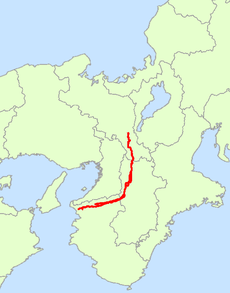
English: Category for the National Route 24 of Japan
日本語: 国道24号に関するカテゴリ
Subcategories
This category has the following 5 subcategories, out of 5 total.
Media in category "Route 24 (Japan)"
The following 97 files are in this category, out of 97 total.
-
2010-9-13 今井町交差点 - panoramio.jpg 1,024 × 768; 284 KB
-
2010-9-4 風ノ森峠 - panoramio.jpg 1,024 × 768; 398 KB
-
2010-9-4 風ノ森峠 北方を見る - panoramio.jpg 768 × 1,024; 314 KB
-
Eneos Tsujimo oil store.JPG 1,280 × 960; 257 KB
-
ESSO Express Nara Bypass SS.jpg 2,540 × 1,892; 1.83 MB
-
Hachijo Over Bridge - panoramio.jpg 2,272 × 1,704; 799 KB
-
Higashikujo Yanagishita town Minami-ku Kyotocity Kyotopref Route 24.JPG 3,264 × 2,448; 3.16 MB
-
Ide Idetown Kyotopref route 24 No,2.JPG 1,280 × 960; 257 KB
-
Ide Idetown Kyotopref route 24.JPG 1,280 × 960; 258 KB
-
Japan National Route 24 Map.png 524 × 668; 49 KB
-
Japan National Route No.24 Sign.svg 256 × 256; 3 KB
-
Japanese National Route Sign 0024.svg 455 × 435; 10 KB
-
Joyo IC.jpg 2,592 × 1,944; 414 KB
-
Joyo JCT・IC.jpg 2,592 × 1,944; 708 KB
-
JRW Saho.jpg 1,200 × 900; 224 KB
-
Kamikoma 四丁町 Kizugawacity Kyotopref Route 24.JPG 1,280 × 960; 266 KB
-
Kamikoma 東下 Kizugawacity Kyotopref Route 24 Former Yamashirotown contry sign.JPG 1,280 × 960; 258 KB
-
Kangetsukyo station.jpg 1,000 × 603; 225 KB
-
Kangetsukyo.JPG 1,280 × 960; 523 KB
-
Kazenomoritouge20100904.JPG 768 × 1,024; 345 KB
-
Kizu 八色 Kizugawacity Kyotopref Route 24.JPG 1,280 × 960; 276 KB
-
Kizu 川原田 Kizugawacity Kyotopref Route 24.JPG 1,280 × 960; 265 KB
-
Makishimatown 三十五 Ujicity Kyotopref route 24.JPG 2,004 × 1,256; 590 KB
-
Makishimatown 十一 Ujicity Kyotopref route 24.JPG 2,304 × 1,728; 1.79 MB
-
Makishimatown 本屋敷 Ujicity Kyotopref route 24.JPG 1,896 × 1,216; 558 KB
-
Michinoeki Resti Karako-Kagi.jpg 4,320 × 3,240; 3.27 MB
-
Momoyama Fukushima Dayunishi town Fushimi-ku Kyotocity Kyotopref Route 24.JPG 2,120 × 1,280; 752 KB
-
Momoyama Tanshita town Fushimi-ku Kyotocity Kyotopref Route 24.JPG 2,304 × 1,728; 1.63 MB
-
Mukaijima Newtown.jpg 1,533 × 1,149; 235 KB
-
Mukaijimamarutown Fushimi-ku Kyotocity Kyotopref Route 24.JPG 2,044 × 1,312; 661 KB
-
Nashima 外島 Joyocity Kyotopref Route 24 Joyocity contry sign.JPG 1,280 × 960; 276 KB
-
Nashima 外島 Joyocity Kyotopref Route 24.JPG 1,280 × 960; 256 KB
-
R024-014.jpg 1,920 × 1,078; 361 KB
-
R024-115.jpg 1,500 × 844; 233 KB
-
R024-122.jpg 1,500 × 844; 162 KB
-
R024-126.jpg 1,600 × 900; 201 KB
-
R024-137.jpg 1,920 × 1,078; 241 KB
-
R024-164.jpg 1,920 × 1,078; 363 KB
-
R024-177.jpg 1,920 × 1,078; 311 KB
-
R024-2020-072.jpg 1,920 × 1,078; 335 KB
-
R024-2020-088.jpg 1,920 × 1,078; 328 KB
-
R024-2020-174.jpg 1,920 × 1,078; 290 KB
-
R024-2020-208.jpg 1,920 × 1,078; 407 KB
-
R024-2020-331.jpg 1,920 × 1,080; 281 KB
-
R024-2020-364.jpg 1,920 × 1,078; 440 KB
-
R024-2020-386.jpg 1,920 × 1,078; 430 KB
-
R024-226.jpg 1,920 × 1,078; 233 KB
-
R024-267.jpg 1,920 × 1,078; 382 KB
-
R024-279.jpg 1,500 × 844; 218 KB
-
R024-321.jpg 1,600 × 900; 312 KB
-
R024-351.jpg 1,500 × 844; 226 KB
-
R025-2020-263.jpg 1,920 × 1,078; 405 KB
-
R042-003-892.jpg 1,920 × 1,078; 401 KB
-
R168-141.jpg 1,920 × 1,078; 377 KB
-
R24 map.png 3,072 × 410; 180 KB
-
R24-Kinokawa001.JPG 1,152 × 864; 984 KB
-
R307-044.jpg 1,499 × 843; 187 KB
-
R310-2020-151.jpg 1,920 × 1,078; 405 KB
-
R369-0000.jpg 1,500 × 844; 234 KB
-
R480-2020-248.jpg 1,920 × 1,078; 289 KB
-
Saganaka 岸間堂 Kizugawacity Kyotopref Keinawa Expxy.JPG 1,280 × 960; 242 KB
-
Sakyo6 Naracity Narapref Route 24.JPG 1,280 × 960; 290 KB
-
Taga Idetown Kyotopref Route 24 and Kyotoprefectural road 321 Watsuka Ide.JPG 1,280 × 960; 260 KB
-
Taga Idetown Kyotopref Route 24 No,2.JPG 1,280 × 960; 269 KB
-
Taga Idetown Kyotopref Route 24 No,3.JPG 1,280 × 960; 259 KB
-
Taga Idetown Kyotopref route 24 pier construction.JPG 1,280 × 960; 260 KB
-
Taga Idetown Kyotopref Route 24.JPG 1,280 × 960; 270 KB
-
Taga 流作 Idetown Kyotopref Route 24 No,2.JPG 1,280 × 960; 268 KB
-
Taga 流作 Idetown Kyotopref Route 24 No,3.JPG 1,280 × 960; 257 KB
-
Taga 流作 Idetown Kyotopref Route 24.JPG 1,280 × 960; 250 KB
-
The street in front of Ichijo High School.jpg 2,560 × 1,920; 2.2 MB
-
Yamashirotown Hirao 上外ノ浜 Kizugawacity Kyotopref Route 24.JPG 1,280 × 960; 270 KB
-
Yamashirotown Kabata 外高島 Kizugawacity Kyotopref Route 24.JPG 1,280 × 960; 253 KB
-
Yamashirotown Kabata 川久保 Kizugawacity Kyotopref Route 24.JPG 1,280 × 960; 277 KB
-
Yamashirotown Kabata 渡り戸 Kizugawacity Kyotopref Route 24.JPG 1,101 × 687; 156 KB
-
Yamashirotown Kabata 藪浦 Kizugawacity Kyotopref Route 24.JPG 1,280 × 960; 283 KB
-
Yamashirotown Kamikoma 北的場 Kizugawacity Kyotopref Route 24.JPG 1,280 × 960; 266 KB
-
Yamashirotown Kamikoma4 Kizugawacity Kyotopref Route 24.JPG 1,280 × 960; 274 KB
-
Yamashirotown Tsubai 北野 Kizugawacity Kyotopref Route 24.JPG 1,280 × 960; 270 KB
-
Yamashirotown Tsubai 水垣内 Kizugawacity Kyotopref Route 24.JPG 1,280 × 960; 256 KB
-
Yamashirotown Tsubai 畑岡 Kizugawacity Kyotopref Route 24.JPG 1,280 × 960; 266 KB
-
Yamashirotown Tsubai 鳥井 Kizugawacity Kyotopref Route 24 No,2.JPG 1,280 × 960; 264 KB
-
Yamashirotown Tsubai 鳥井 Kizugawacity Kyotopref Route 24.JPG 1,280 × 960; 264 KB
-
Zaimotokutown(Shichijodori) Simogyo-ku Kyotocity Kyotopref Route 24.JPG 1,328 × 976; 450 KB
-
国道24号 五條市住川町にて Sugawa-chō 2011.4.29 - panoramio.jpg 2,048 × 1,536; 706 KB
-
国道24号鴨神交差点と風の森バス停 Kamogami intersection and Kazenomori bus stop 2011.5.14 - panoramio.jpg 2,560 × 1,920; 2.41 MB
-
大畑 Idetown Kyotopref route 24.JPG 1,280 × 960; 272 KB
-
扇畑 Idetown Kyotopref Route 24.JPG 1,280 × 960; 261 KB
-
新堂ランプ 2017 気温2 風速6 (32756616646).jpg 3,872 × 2,592; 1.14 MB
-
曲川町7丁目南交差点 Magarikawachō-7-chōme-minami 2011.7.05 - panoramio.jpg 2,048 × 1,536; 809 KB
-
本陣交差点付近01.JPG 1,024 × 768; 171 KB
-
橋ノ本 Idetown Kyotopref Route 24 sign.JPG 1,280 × 960; 269 KB
-
橋ノ本 Idetown Kyotopref Route 24.JPG 1,280 × 960; 259 KB
-
烏丸通 - panoramio.jpg 1,440 × 1,920; 470 KB
-
神野々(このの)/大和街道/橋本市 - Panoramio 31482061.jpg 1,024 × 692; 201 KB
-
道の駅紀の川万葉の里01.jpg 1,632 × 918; 190 KB


