Category:Rothley, Leicestershire
Jump to navigation
Jump to search
Main Wikipedia article: Rothley.

village and civil parish in Leicestershire, UK  | |||||
| Upload media | |||||
| Instance of | |||||
|---|---|---|---|---|---|
| Location | Charnwood, Leicestershire, East Midlands, England | ||||
| Population |
| ||||
| Said to be the same as | Rothley (Wikimedia duplicated page, civil parish) | ||||
 | |||||
Subcategories
This category has the following 4 subcategories, out of 4 total.
R
- Rothley Court (8 F)
Media in category "Rothley, Leicestershire"
The following 200 files are in this category, out of 278 total.
(previous page) (next page)-
 "Leicester City" at Rothley - geograph.org.uk - 6141156.jpg 5,472 × 3,648; 7.29 MB
-
 80 Town Green Street, Rothley - geograph.org.uk - 3657472.jpg 1,280 × 960; 247 KB
-
 81 Town Green Street, Rothley - geograph.org.uk - 3657468.jpg 1,280 × 960; 254 KB
-
 81 Town Green Street, Rothley - geograph.org.uk - 3657475.jpg 1,280 × 960; 261 KB
-
 89 Town Green Street, Rothley - geograph.org.uk - 3657478.jpg 640 × 474; 104 KB
-
 91 Town Green Street - geograph.org.uk - 3657467.jpg 1,280 × 960; 263 KB
-
 A46 bridge crossing Cossington Lane - geograph.org.uk - 4212989.jpg 1,600 × 1,255; 515 KB
-
 A6 Loughborough Road enters Rothley - geograph.org.uk - 4306525.jpg 1,600 × 986; 309 KB
-
 A6 Loughborough Road in Rothley - geograph.org.uk - 4306543.jpg 1,600 × 992; 371 KB
-
 A6 Loughborough Road near Mountsorrel - geograph.org.uk - 4306618.jpg 1,600 × 1,071; 444 KB
-
 Above Cossington Lock - geograph.org.uk - 3657517.jpg 1,280 × 960; 239 KB
-
 Back Garden in 2008 - panoramio.jpg 3,264 × 2,448; 1.58 MB
-

-

-
 Back of House - panoramio (1).jpg 720 × 480; 295 KB
-
 Back of House - panoramio.jpg 720 × 480; 320 KB
-
 Back of the old big barn - panoramio.jpg 5,184 × 3,456; 9.96 MB
-
 Barn Conversion Rothley - panoramio.jpg 945 × 630; 273 KB
-
 Brickyard Farm - geograph.org.uk - 3657446.jpg 1,280 × 960; 467 KB
-
 Bridge 22 - below Sileby Lock - geograph.org.uk - 2351094.jpg 640 × 424; 76 KB
-
 Bridge number 23 on the Soar Canal - geograph.org.uk - 6522635.jpg 3,776 × 2,520; 3.95 MB
-
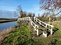
 Bridge over the Rothley Brook - geograph.org.uk - 3657480.jpg 1,280 × 960; 385 KB
-
 Bridleway from Rothley to Thurcaston - geograph.org.uk - 4625364.jpg 2,000 × 1,500; 683 KB
-
 Brookfield Farm - geograph.org.uk - 1640403.jpg 640 × 480; 157 KB
-
 Brooklea Nurseries - geograph.org.uk - 724567.jpg 640 × 359; 49 KB
-
 Catholic Church of the Sacred Heart - geograph.org.uk - 5008051.jpg 2,000 × 1,500; 332 KB
-
 Church Street, Rothley (geograph 7421277).jpg 1,024 × 768; 166 KB
-
 Confluence of the River Wreake and the River Soar - geograph.org.uk - 4471616.jpg 1,743 × 1,181; 183 KB
-

-
 Cossington Lane Bridge No 21 - geograph.org.uk - 6371513.jpg 800 × 661; 84 KB
-
 Cossington Lane towards Rothley - geograph.org.uk - 853305.jpg 640 × 434; 58 KB
-
 Cossington Lock - geograph.org.uk - 3657515.jpg 1,280 × 960; 366 KB
-
 Cossington Lock - geograph.org.uk - 4471615.jpg 1,191 × 1,684; 142 KB
-
 Cossington Lock along the Grand Union Canal - geograph.org.uk - 3779405.jpg 1,600 × 1,200; 698 KB
-
 Cossington Lock along the Grand Union Canal - geograph.org.uk - 3779438.jpg 1,600 × 1,200; 734 KB
-
 Cossington Lock along the Grand Union Canal - geograph.org.uk - 4199290.jpg 1,600 × 1,234; 440 KB
-
 Cossington Lock No 48 - geograph.org.uk - 5548942.jpg 800 × 625; 165 KB
-
 Cossington Lock No 48 - geograph.org.uk - 6371501.jpg 800 × 583; 161 KB
-
 Cossington Lock north-east of Rothley in Leicestershire - geograph.org.uk - 5978418.jpg 1,440 × 1,080; 1.66 MB
-
 Cossington Lock River Soar Navigation - geograph.org.uk - 3168217.jpg 2,074 × 1,415; 984 KB
-
 Cossington Weir - geograph.org.uk - 3657518.jpg 1,280 × 960; 524 KB
-
 Cossington Weir near Cossington Mill - geograph.org.uk - 3779416.jpg 1,600 × 1,161; 641 KB
-
 Cossington Weir sluices - geograph.org.uk - 3657526.jpg 1,280 × 960; 421 KB
-

-
 Cow Corner - geograph.org.uk - 3657460.jpg 1,280 × 960; 430 KB
-
 Cross Green, Rothley - panoramio.jpg 3,264 × 2,448; 2.13 MB
-
 Cycling along Swithland Lane in Rothley Plain - geograph.org.uk - 4308097.jpg 1,024 × 833; 258 KB
-
 End of public highway - geograph.org.uk - 3657495.jpg 960 × 1,280; 437 KB
-
 Entering Rothley on Cycle Route 6 - geograph.org.uk - 2839213.jpg 4,000 × 3,000; 4.5 MB
-

-
 Entrance to Rothley Court - geograph.org.uk - 4625373.jpg 640 × 480; 72 KB
-
-
 Farmland with trees, near Rothley Plain - geograph.org.uk - 6631923.jpg 1,600 × 1,200; 460 KB
-
 Farnham Bridge crossing Rothley Brook - geograph.org.uk - 4306554.jpg 1,600 × 1,176; 574 KB
-
 Fields on the edge of Mountsorrel - geograph.org.uk - 4656471.jpg 800 × 678; 177 KB
-
 Fingerpost along Swithland Lane - geograph.org.uk - 4657082.jpg 800 × 513; 229 KB
-

-
 Florrie at Sileby Marina - geograph.org.uk - 6387069.jpg 3,648 × 2,432; 4.17 MB
-
 Footbridge along the River Soar - geograph.org.uk - 3779446.jpg 1,600 × 1,200; 420 KB
-
 Footbridge along the River Soar - geograph.org.uk - 3779483.jpg 1,600 × 1,200; 769 KB
-
 Footbridge at Sileby Lock - geograph.org.uk - 6387075.jpg 3,648 × 2,432; 4.32 MB
-
 Footbridge over Rothley Brook - geograph.org.uk - 6179426.jpg 1,410 × 1,057; 524 KB
-
 Footbridge over the River Soar - geograph.org.uk - 6387065.jpg 3,648 × 2,432; 4.81 MB
-

-
 Footpath crossing an arm of the River Soar - geograph.org.uk - 6522616.jpg 3,776 × 2,520; 4.2 MB
-
 Footpath marker near the River Soar - geograph.org.uk - 3779286.jpg 1,600 × 1,250; 952 KB
-
 Footpath off The Ridings - geograph.org.uk - 3657089.jpg 1,280 × 960; 300 KB
-
 Footpath towards the Wanlip wind turbine - geograph.org.uk - 4213042.jpg 1,600 × 1,200; 618 KB
-
 Forest Lodge on Kinchley Lane - geograph.org.uk - 4657121.jpg 800 × 650; 149 KB
-
 Former derelict main barn at Six Acres Rothley - panoramio.jpg 5,184 × 3,456; 6.87 MB
-
 Fowke Street 2,Rothley - panoramio.jpg 3,264 × 2,448; 2.41 MB
-
 Fowke Street, Rothley - panoramio.jpg 3,264 × 2,448; 2.24 MB
-
 Fowke Street, Street Prospective, Rothley - panoramio.jpg 3,264 × 2,448; 2.18 MB
-
 Fowke Street,Rothley - panoramio.jpg 3,264 × 2,448; 2.19 MB
-
 Fowke Street,The White Building,Rothley - panoramio.jpg 3,264 × 2,448; 2.14 MB
-
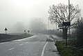 Freezing fog along the A6 Loughborough Road - geograph.org.uk - 4306532.jpg 1,600 × 1,078; 318 KB
-
 Garage - panoramio (19).jpg 4,000 × 3,000; 2.24 MB
-
 Garage and Workshop under construction - panoramio.jpg 3,072 × 2,304; 2.9 MB
-
 Geese and goslings - geograph.org.uk - 3962987.jpg 1,600 × 1,123; 592 KB
-
 Goods train approaching Rothley - geograph.org.uk - 5572776.jpg 5,202 × 3,465; 3.04 MB
-
 Grazing sheep near Swithland Reservoir - geograph.org.uk - 4657327.jpg 800 × 639; 152 KB
-
 Great Central Railway - geograph.org.uk - 4183597.jpg 1,600 × 1,046; 320 KB
-
 Great Central Railway - geograph.org.uk - 6475412.jpg 1,200 × 803; 1.46 MB
-

-
 GWR Prairie 4141 at Rothley - geograph.org.uk - 6143953.jpg 2,304 × 1,728; 1.4 MB
-
 Hedged fields, near Rothley Plain - geograph.org.uk - 6631918.jpg 1,600 × 1,199; 612 KB
-
 Heritage Centre - geograph.org.uk - 6456680.jpg 1,600 × 900; 416 KB
-
 Horses along Cossington Lane - geograph.org.uk - 3962995.jpg 1,600 × 1,262; 617 KB
-
 Horses near the A6 - geograph.org.uk - 3779398.jpg 1,600 × 1,154; 586 KB
-
 Houses in Rothley - geograph.org.uk - 6439279.jpg 768 × 1,024; 167 KB
-
 Houses on Armitage Drive in Rothley - geograph.org.uk - 5548702.jpg 800 × 617; 165 KB
-
 Inside of the former Westfield Farm Barn - panoramio.jpg 3,456 × 5,184; 6.45 MB
-
-
 Keeper's Cottage, Town Green Rothley - geograph.org.uk - 3657458.jpg 1,280 × 960; 368 KB
-
 Kinchley Lane near Swithland Reservoir - geograph.org.uk - 4657337.jpg 800 × 605; 164 KB
-
-
 Lock No 49, River Soar, Sileby Mill - geograph.org.uk - 1953745.jpg 2,592 × 1,944; 244 KB
-
 Lock No 49, River Soar, Sileby Mill - geograph.org.uk - 1955546.jpg 2,000 × 1,500; 187 KB
-
 Loughborough Road in Rothley - geograph.org.uk - 3962975.jpg 1,600 × 1,352; 442 KB
-
 McCann Tributes1.jpg 965 × 1,163; 387 KB
-
 Montsorrel Lane, Rothley - geograph.org.uk - 3657482.jpg 1,280 × 960; 464 KB
-
 Moored between two weirs at Sileby Mill - geograph.org.uk - 6179251.jpg 1,600 × 900; 231 KB
-

-
 Moored narrowboats at the Boat House - geograph.org.uk - 6371523.jpg 800 × 678; 140 KB
-
 Mountsorrel and Rothley Community Heritage Centre - geograph.org.uk - 4673204.jpg 1,800 × 1,200; 926 KB
-
 Mountsorrel Granite railway wagons - geograph.org.uk - 6631910.jpg 1,600 × 1,199; 703 KB
-
 Mountsorrel Railway - geograph.org.uk - 2780815.jpg 640 × 424; 296 KB
-
 Mountsorrel Railway Museum - geograph.org.uk - 6631889.jpg 1,600 × 1,200; 628 KB
-
 Narrow gauge tub wagons, Nunckley Hill station - geograph.org.uk - 6631882.jpg 1,600 × 1,200; 514 KB
-
 New Driveway - panoramio (1).jpg 3,264 × 2,448; 1.4 MB
-
 New Driveway - panoramio.jpg 5,184 × 3,456; 8.2 MB
-
 New garage and workshop - panoramio.jpg 3,072 × 2,304; 2.31 MB
-
 New garage and workshop under construction - panoramio.jpg 3,072 × 2,304; 2.3 MB
-
 New road to Rothley Meadow - geograph.org.uk - 5548731.jpg 800 × 573; 73 KB
-
 Newtown Cottages - geograph.org.uk - 3657444.jpg 1,280 × 960; 396 KB
-
 Non-stop to Leicester North - geograph.org.uk - 5663904.jpg 640 × 427; 91 KB
-
 North along Mountsorrel Lane - geograph.org.uk - 4471571.jpg 1,024 × 834; 323 KB
-
 Northern face, former granite quarry, Mountsorrel - geograph.org.uk - 6631901.jpg 1,600 × 1,200; 769 KB
-
 Numbers 78 & 80 Town Green Street, Rothley (geograph 7516535).jpg 3,776 × 2,520; 4.19 MB
-

-
 Observing steam - geograph.org.uk - 2782815.jpg 424 × 640; 175 KB
-
 Off Fowke Street, Rothley - geograph.org.uk - 6621908.jpg 768 × 1,024; 186 KB
-
 Old Barn at Six Acres Rothley in 2010 - panoramio.jpg 5,184 × 3,456; 4.93 MB
-
 Old cottages before demolition - panoramio.jpg 787 × 591; 447 KB
-
 Old course of the River Soar - geograph.org.uk - 6179434.jpg 1,600 × 1,200; 348 KB
-
 Out of the church gates, Rothley - geograph.org.uk - 6457527.jpg 1,600 × 900; 333 KB
-

-

-

-
 Private track to Swithland Reservoir - geograph.org.uk - 4657344.jpg 800 × 549; 214 KB
-
 Public footpath along the edge of a field - geograph.org.uk - 3779280.jpg 1,600 × 1,219; 762 KB
-
 Public footpath along the edge of a field - geograph.org.uk - 3779292.jpg 1,600 × 1,188; 654 KB
-
 Pylon near Rothley Station - geograph.org.uk - 3034273.jpg 1,249 × 1,220; 742 KB
-
 Quarry Heritage Building - geograph.org.uk - 6631896.jpg 1,600 × 1,200; 591 KB
-
 Quarry restoration - geograph.org.uk - 2780823.jpg 640 × 424; 201 KB
-
 Railway track, Mountsorrel ^ Rothley heritage centre - geograph.org.uk - 6631908.jpg 1,600 × 1,200; 664 KB
-
 Red Lion in Rothley - geograph.org.uk - 861720.jpg 640 × 488; 47 KB
-

-
 Repairing the Lock - geograph.org.uk - 132173.jpg 640 × 427; 139 KB
-
 River Soar - geograph.org.uk - 6387060.jpg 3,648 × 2,432; 5.41 MB
-
 River Soar - geograph.org.uk - 6387061.jpg 3,648 × 2,432; 4.66 MB
-
 River Soar - geograph.org.uk - 6387070.jpg 3,648 × 2,432; 4.82 MB
-
 River Soar at the Boat House - geograph.org.uk - 5143919.jpg 492 × 800; 129 KB
-
 River Soar below Cossington Lock in Leicestershire - geograph.org.uk - 5978746.jpg 960 × 1,280; 1.44 MB
-
 River Soar Cossington Mill Weir - geograph.org.uk - 2351092.jpg 640 × 424; 88 KB
-

-
 River Soar near Mountsorrel in Leicestershire - geograph.org.uk - 5980871.jpg 1,280 × 960; 1.55 MB
-
 River Soar near Mountsorrel in Leicestershire - geograph.org.uk - 5981113.jpg 1,440 × 1,080; 1.83 MB
-
 River Soar near Mountsorrel in Leicestershire - geograph.org.uk - 5981116.jpg 1,440 × 960; 1.53 MB
-
 River Soar near Mountsorrel in Leicestershire - geograph.org.uk - 5981578.jpg 1,440 × 960; 1.34 MB
-
 River Soar near Rothley, Leicestershire - geograph.org.uk - 3635324.jpg 1,440 × 995; 1.22 MB
-
 River Soar north-east of Rothley in Leicestershire - geograph.org.uk - 5977830.jpg 960 × 1,280; 1.68 MB
-
 River Soar north-east of Rothley in Leicestershire - geograph.org.uk - 5978831.jpg 1,440 × 960; 1.52 MB
-
 River Soar north-east of Rothley in Leicestershire - geograph.org.uk - 5978856.jpg 1,440 × 960; 1.39 MB
-
 River Soar north-east of Rothley in Leicestershire - geograph.org.uk - 5978866.jpg 1,440 × 960; 1.26 MB
-
 River Soar north-east of Rothley in Leicestershire - geograph.org.uk - 5978874.jpg 1,440 × 960; 1.64 MB
-
 River Soar north-east of Rothley in Leicestershire - geograph.org.uk - 5978898.jpg 1,600 × 900; 1.62 MB
-
 Roman Catholic Church of the Sacred Heart - geograph.org.uk - 3657485.jpg 1,280 × 960; 335 KB
-
 Rothley Brook - geograph.org.uk - 3826544.jpg 640 × 427; 84 KB
-
 Rothley Brook bridge - geograph.org.uk - 3657508.jpg 1,280 × 960; 265 KB
-
 Rothley Brook next to Town Green Street - geograph.org.uk - 5738832.jpg 800 × 500; 144 KB
-
 Rothley Brook viewed from Farnham Bridge - geograph.org.uk - 4306607.jpg 1,600 × 1,239; 414 KB
-
 Rothley Cemetery Chapel - geograph.org.uk - 3657488.jpg 1,280 × 960; 282 KB
-
 Rothley Court boundary wall - geograph.org.uk - 3657450.jpg 1,280 × 960; 367 KB
-
 Rothley Court Lodge - geograph.org.uk - 3657449.jpg 1,280 × 960; 445 KB
-
 Rothley Cross - geograph.org.uk - 2259793.jpg 800 × 539; 122 KB
-
 Rothley Cross - geograph.org.uk - 2259796.jpg 800 × 531; 123 KB
-
 Rothley for Loughborough - geograph.org.uk - 6039049.jpg 640 × 427; 83 KB
-
 Rothley Meadow - geograph.org.uk - 5548734.jpg 800 × 590; 99 KB
-
 Rothley Meadow - geograph.org.uk - 5548736.jpg 800 × 599; 110 KB
-
 Rothley Park - geograph.org.uk - 1639694.jpg 640 × 480; 380 KB
-
 Rothley Park Cricket Club - geograph.org.uk - 3657463.jpg 1,280 × 960; 229 KB
-
 Rothley Plain - geograph.org.uk - 3657442.jpg 1,280 × 960; 309 KB
-
 Rothley Plain postbox ref LE7 346 - geograph.org.uk - 3657093.jpg 1,280 × 960; 478 KB
-
 Rothley signal box - geograph.org.uk - 5572766.jpg 5,202 × 3,465; 2.78 MB
-
 Rothley Station - For Leicester North - geograph.org.uk - 6746790.jpg 3,864 × 2,576; 3.68 MB
-
 Rothley Station - geograph.org.uk - 6746028.jpg 2,998 × 3,526; 4.28 MB
-
 Rothley Station - geograph.org.uk - 6746035.jpg 2,766 × 4,064; 4.18 MB
-
 Rothley Station, Great Central Railway - geograph.org.uk - 6699797.jpg 1,024 × 676; 161 KB
-
 Rothley Telephone Exchange, Leics - geograph.org.uk - 3975435.jpg 3,072 × 2,304; 1.76 MB
-
 Rothley Village - geograph.org.uk - 1640410.jpg 640 × 480; 293 KB
-
 Rothley village sign - geograph.org.uk - 3657092.jpg 1,280 × 960; 507 KB
-

-
 Rothley, UK - panoramio (2).jpg 3,456 × 5,184; 9.61 MB
-
 Rothley, UK - panoramio (3).jpg 5,184 × 3,456; 6.25 MB
-
 Rowe Leyes Furlong - geograph.org.uk - 3657489.jpg 1,280 × 960; 291 KB
-
 School Street,Rothley - panoramio.jpg 3,264 × 2,448; 2.2 MB
-
 Sculpture at the A6 roundabout, Rothley - geograph.org.uk - 3657498.jpg 960 × 1,280; 236 KB
-
 Sheep and pasture near Buddon Wood - geograph.org.uk - 4657332.jpg 800 × 566; 145 KB
-
 Sileby Lock - geograph.org.uk - 31809.jpg 427 × 640; 85 KB
-
 Sileby Mill - geograph.org.uk - 2877324.jpg 1,600 × 1,200; 1.02 MB
-
 Sileby Mill - geograph.org.uk - 6387074.jpg 3,648 × 2,432; 4.68 MB
-
 Sileby Mill and marina, River Soar - geograph.org.uk - 1953987.jpg 2,000 × 1,498; 188 KB
-
 Sileby Mill and marina, River Soar - geograph.org.uk - 1953993.jpg 2,000 × 1,485; 209 KB
-
 Six Acres ( formerly Westfield Farm ) The Ridgeway Rothley Leicestershire - panoramio.jpg 1,536 × 2,048; 1.31 MB
-
 Six Acres around 2010 - panoramio.jpg 3,008 × 2,000; 2.8 MB
-
 Six Acres Rothley Leicestershire - panoramio.jpg 5,184 × 3,456; 7.77 MB
-
 Six Acres The Ridgeway Rothley Leicestershire LE7 7LE - panoramio (1).jpg 3,072 × 2,304; 2.56 MB
-
 Six Acres The Ridgeway Rothley Leicestershire LE7 7LE - panoramio (2).jpg 2,304 × 3,072; 2.75 MB
-
 Six Acres The Ridgeway Rothley Leicestershire LE7 7LE - panoramio.jpg 945 × 630; 297 KB


.jpg)

.jpg)


.jpg)


.jpg)


.jpg)


.jpg)


.jpg)
.jpg)


_The_Ridgeway_Rothley_Leicestershire_-_panoramio.jpg)


.jpg)
.jpg)
