Category:Rosedale Abbey
Jump to navigation
Jump to search
village in the United Kingdom  | |||||
| Upload media | |||||
| Instance of | |||||
|---|---|---|---|---|---|
| Location | Rosedale East Side, Ryedale, North Yorkshire, Yorkshire and the Humber, England | ||||
| Inception |
| ||||
 | |||||
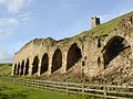
Deutsch: Rosedale Abbey ist ein Dorf in North Yorkshire. Gelegen inmitten der North York Moors in einem besonders unzugänglichen Tal, ist es die einzige größere Menschenansammlung im zentralen Teil des Moors. Im Tal Rosedale befand sich zwischen 1158 und 1536 ein Kloster des Zisterzienserordens, dessen Ruinen noch heute vorhanden sind.
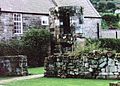
English: Rosedale Abbey is a village located in a spectacular valley in the centre of Rosedale, North Yorkshire, England, midway between Pickering and Castleton in an area of rolling hillsides and stunning scenery. The village consists of a collection of quaint cottages, pubs, a church, an art gallery, tea room, glass studio and the village green.
Subcategories
This category has the following 2 subcategories, out of 2 total.
Media in category "Rosedale Abbey"
The following 200 files are in this category, out of 220 total.
(previous page) (next page)-
 A barn known as High Hamer - geograph.org.uk - 94156.jpg 640 × 411; 88 KB
-

-
 Abbey Stores - geograph.org.uk - 2620992.jpg 640 × 636; 321 KB
-
 Abbey Stores tea room at Rosedale Abbey - geograph.org.uk - 3090590.jpg 1,024 × 767; 193 KB
-
 Abbey Stores, Rosedale Abbey - geograph.org.uk - 2653172.jpg 1,024 × 768; 197 KB
-

-
 Alder Carr Lane, Rosedale Abbey - geograph.org.uk - 1308391.jpg 640 × 426; 103 KB
-
 Avenue of trees, Rosedale Abbey - geograph.org.uk - 177609.jpg 608 × 388; 67 KB
-
 Barn at High Hamer - geograph.org.uk - 232636.jpg 640 × 412; 69 KB
-
 Barn, High Wold House - geograph.org.uk - 410804.jpg 640 × 426; 77 KB
-
 Blue Skies And Cattle Grid - geograph.org.uk - 1329914.jpg 640 × 480; 87 KB
-
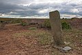 Boundary Stone, White Moor - geograph.org.uk - 1392265.jpg 640 × 427; 67 KB
-
 Bow Bridge 1789 River Rye Rosedale North Yorkshire.jpg 5,184 × 3,456; 12.98 MB
-

-
 Cottage at Thorgill - geograph.org.uk - 95089.jpg 640 × 475; 92 KB
-
 Cottages near to Rosedale Chimney - geograph.org.uk - 39238.jpg 640 × 480; 92 KB
-
 Craven Farm - Rosedale - geograph.org.uk - 125185.jpg 640 × 427; 67 KB
-

-
 Derelict Coal Bunkers, East Mines, Rosedale Abbey - geograph.org.uk - 2596387.jpg 2,136 × 1,424; 1.17 MB
-
 Doorway into garden at Rosedale Abbey - geograph.org.uk - 3177179.jpg 1,024 × 768; 518 KB
-
 Early Iron - geograph.org.uk - 498162.jpg 477 × 640; 102 KB
-
 England in the wasteland - geograph.org.uk - 201988.jpg 640 × 390; 44 KB
-
 Farndale Daffodils - geograph.org.uk - 339870.jpg 474 × 640; 117 KB
-
 Footpath at White Moor. - geograph.org.uk - 194398.jpg 640 × 480; 86 KB
-
 Former Rosedale Goods Depot - geograph.org.uk - 847347.jpg 640 × 427; 204 KB
-
 Grange Farm, Rosedale - geograph.org.uk - 75193.jpg 640 × 427; 113 KB
-
 Hamer House Ruins - geograph.org.uk - 149508.jpg 640 × 427; 69 KB
-
 Hamer Moor - geograph.org.uk - 685382.jpg 640 × 427; 84 KB
-
 Hill Cottages, Rosedale - geograph.org.uk - 21154.jpg 640 × 480; 60 KB
-
 Millennium Cross near Rosedale Abbey - geograph.org.uk - 38644.jpg 640 × 428; 37 KB
-
 New Road, above Rosedale - geograph.org.uk - 896287.jpg 640 × 480; 205 KB
-
 Old stone water troughs by Hartoft Bridge - geograph.org.uk - 149398.jpg 640 × 427; 121 KB
-
 Ordnance Survey Sheet SE 79 Rosedale Abbey, Published 1954.jpg 7,335 × 7,468; 15.07 MB
-
 Pasture Fields, Hamer Moor - geograph.org.uk - 686495.jpg 640 × 384; 50 KB
-

-
 Pile of Stones on Spaunton Moor - geograph.org.uk - 213831.jpg 640 × 480; 126 KB
-
 Pile of Stones, Hamer Moor - geograph.org.uk - 686438.jpg 640 × 427; 87 KB
-
 Pond, Hamer Moor - geograph.org.uk - 686451.jpg 640 × 384; 80 KB
-
 Red House Farm - Rosedale - geograph.org.uk - 207256.jpg 640 × 479; 118 KB
-
 Road Junction, Lamb Fod Hill - geograph.org.uk - 1328294.jpg 640 × 480; 72 KB
-
 Rocks on Spaunton Moor - geograph.org.uk - 640262.jpg 640 × 427; 73 KB
-
 Rosedale Abbey - village boundary - geograph.org.uk - 1981974.jpg 640 × 480; 96 KB
-
 Rosedale Abbey, Village Centre - geograph.org.uk - 2708403.jpg 2,136 × 1,424; 1.62 MB
-
 Rosedale Show - geograph.org.uk - 244285.jpg 640 × 426; 244 KB
-
 Rosedale Show - geograph.org.uk - 244286.jpg 640 × 426; 256 KB
-
 Rosedale Show - geograph.org.uk - 244288.jpg 426 × 640; 284 KB
-
 Spaunton trig - geograph.org.uk - 164413.jpg 640 × 480; 99 KB
-
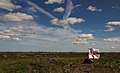
 Telecoms mast above Rosedale Abbey - geograph.org.uk - 735304.jpg 449 × 640; 42 KB
-
 The former Methodist chapel, Rosedale Abbey - geograph.org.uk - 3607050.jpg 1,024 × 768; 208 KB
-
 The only remains of Rosedale Abbey - geograph.org.uk - 2459071.jpg 589 × 900; 309 KB
-
 The remains of Rosedale Abbey - geograph.org.uk - 1611720.jpg 640 × 456; 117 KB
-
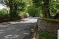
 The road down to Rosedale Abbey - geograph.org.uk - 2432593.jpg 1,024 × 768; 118 KB
-
 TV repeater mast at Rosedale - geograph.org.uk - 735296.jpg 640 × 420; 79 KB
-
 Updale Reading Room, Rosedale Abbey - geograph.org.uk - 2596377.jpg 2,000 × 1,500; 1.18 MB
-
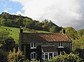
 Victorian architecture, Rosedale Abbey - geograph.org.uk - 2653155.jpg 800 × 600; 145 KB
-

-
 Water reservoir near Bell Top - geograph.org.uk - 319960.jpg 640 × 427; 61 KB
-
 Weir on the River Dove - geograph.org.uk - 410807.jpg 640 × 426; 94 KB
-
 Yatts Farm - geograph.org.uk - 1498619.jpg 640 × 427; 112 KB
-
 Yatts Farm, Rosedale Abbey - geograph.org.uk - 2708411.jpg 2,136 × 1,424; 960 KB
-
 'Green' Lane at Hollin Bush Farm - geograph.org.uk - 846594.jpg 640 × 427; 285 KB
-
 A small stream joins Loskey Beck - geograph.org.uk - 372569.jpg 427 × 640; 92 KB
-
 A Tight Meander of the River Dove - geograph.org.uk - 751711.jpg 640 × 427; 120 KB
-
 Airwave mast near Cote Hill - geograph.org.uk - 665526.jpg 640 × 427; 79 KB
-
 Animal steading in Rosedale - geograph.org.uk - 335746.jpg 640 × 480; 105 KB
-
 Approaching High Wold House - geograph.org.uk - 753099.jpg 640 × 427; 89 KB
-
 Barn and Reservoir - geograph.org.uk - 106214.jpg 640 × 482; 67 KB
-
 Barn at Bitchagreen - geograph.org.uk - 753122.jpg 640 × 427; 107 KB
-
 Barn in North or Noddy Dale - geograph.org.uk - 106132.jpg 640 × 482; 71 KB
-
 Barn, Job's Well (Chalybeate) - geograph.org.uk - 106143.jpg 640 × 482; 60 KB
-
 Barns at Hollin Bush Farm - geograph.org.uk - 847310.jpg 640 × 427; 269 KB
-
 Bell End Farm - geograph.org.uk - 177613.jpg 640 × 415; 82 KB
-
 Below Nab Scar - geograph.org.uk - 840317.jpg 640 × 488; 242 KB
-
 Bitchagreen - geograph.org.uk - 753114.jpg 640 × 427; 74 KB
-
 Black Moor Rigg. - geograph.org.uk - 194389.jpg 640 × 480; 99 KB
-
 Boundary Stone on the Lyke Wake Path. - geograph.org.uk - 194786.jpg 640 × 480; 155 KB
-
 Boundary Stone, Shunner Howe - geograph.org.uk - 106193.jpg 640 × 482; 62 KB
-
 Bragg Farm - geograph.org.uk - 348087.jpg 640 × 399; 36 KB
-
 Bragg Farm - geograph.org.uk - 466368.jpg 640 × 427; 61 KB
-
 Bridge over Beck - geograph.org.uk - 753144.jpg 640 × 427; 125 KB
-
 Bridge over Bluewath Beck - geograph.org.uk - 735289.jpg 640 × 427; 98 KB
-

-

-
 Cairn, Taylor's Nab - geograph.org.uk - 410820.jpg 640 × 426; 92 KB
-
-
 Car Park, Rosedale Chimney - geograph.org.uk - 537117.jpg 640 × 480; 124 KB
-
 Castleton to Hutton-le-Hole road - geograph.org.uk - 177462.jpg 640 × 427; 49 KB
-
 Cattle grid on Hancow Road - geograph.org.uk - 149459.jpg 640 × 427; 52 KB
-
 Chimney bank view - geograph.org.uk - 640091.jpg 640 × 427; 61 KB
-
 Chimney Bank with snow - geograph.org.uk - 372572.jpg 640 × 404; 53 KB
-
 Clapper Bridge, Northdale Beck - geograph.org.uk - 106137.jpg 640 × 482; 93 KB
-
 Converted school at Hartoft - geograph.org.uk - 149436.jpg 640 × 427; 70 KB
-
 Cote Hill - geograph.org.uk - 665528.jpg 640 × 427; 51 KB
-
 Cottongrass, Round Hill, Rosedale - geograph.org.uk - 20652.jpg 640 × 480; 82 KB
-

-
 Crook Beck - geograph.org.uk - 686426.jpg 427 × 640; 97 KB
-
 Ditch Near High Wold House - geograph.org.uk - 753111.jpg 640 × 427; 114 KB
-
 Downhill here to Hartoft End - geograph.org.uk - 214859.jpg 640 × 480; 112 KB
-
 Duks Ley Farm, Hartoft (near Rosedale) - geograph.org.uk - 75191.jpg 640 × 427; 127 KB
-
 Ebenezer Methodist Chapel, Rosedale - geograph.org.uk - 20665.jpg 640 × 480; 67 KB
-
 Empty house at Low Gill - geograph.org.uk - 207255.jpg 640 × 479; 116 KB
-
 Erosion Gully, Lyke Wake Walk - geograph.org.uk - 185764.jpg 480 × 640; 99 KB
-
 Farndale - geograph.org.uk - 148.jpg 640 × 480; 105 KB
-
 Farndale - geograph.org.uk - 2219.jpg 480 × 640; 79 KB
-
 Farndale From High Bragg House - geograph.org.uk - 410830.jpg 640 × 384; 55 KB
-
 Farndale View - geograph.org.uk - 270214.jpg 640 × 427; 36 KB
-
 Fence and Ditch near Bitchagreen - geograph.org.uk - 753126.jpg 427 × 640; 86 KB
-
 Fire point and frog spawn - geograph.org.uk - 149474.jpg 640 × 427; 86 KB
-
 Footbridge, Hamer Beck - geograph.org.uk - 106154.jpg 640 × 480; 160 KB
-
 Ford and footbridge - Rosedale - geograph.org.uk - 207260.jpg 479 × 640; 121 KB
-
 Ford and footbridge to Head House - geograph.org.uk - 149435.jpg 640 × 427; 86 KB
-
 Ford near Low Muffles - geograph.org.uk - 216384.jpg 640 × 480; 107 KB
-
 Forest edge above Hartoft - geograph.org.uk - 149478.jpg 640 × 427; 57 KB
-
 Forest Road Bend, Muffles Rigg - geograph.org.uk - 152923.jpg 640 × 480; 65 KB
-
 Former Rosedale Goods Depot - geograph.org.uk - 20643.jpg 640 × 480; 65 KB
-
 Gate, Hamer Beck - geograph.org.uk - 685361.jpg 640 × 427; 102 KB
-
 Gate, Row Mires Rigg - geograph.org.uk - 685399.jpg 640 × 427; 383 KB
-
 Gated track - geograph.org.uk - 320100.jpg 640 × 404; 37 KB
-
 Gill Bank - geograph.org.uk - 20646.jpg 640 × 480; 67 KB
-
 Grouse Butt on Yarsley Moss. - geograph.org.uk - 194788.jpg 640 × 480; 113 KB
-
 Grouse Butts, Near Hamer House - geograph.org.uk - 685367.jpg 640 × 384; 65 KB
-
 Hamer Beck - geograph.org.uk - 686431.jpg 640 × 427; 94 KB
-
 Hancow Road cattle grid near Rosedale - geograph.org.uk - 40259.jpg 640 × 480; 93 KB
-
 Hartoft Parish Notice Board - geograph.org.uk - 537208.jpg 640 × 480; 104 KB
-
 High Baring, Rosedale East Mine - geograph.org.uk - 20659.jpg 640 × 480; 51 KB
-
 High Bragg House - geograph.org.uk - 466365.jpg 640 × 427; 58 KB
-
 High Gill - geograph.org.uk - 24432.jpg 640 × 480; 63 KB
-
 High Row Mires - geograph.org.uk - 149452.jpg 640 × 427; 85 KB
-
 High Windhill - Hartoft - geograph.org.uk - 149441.jpg 640 × 427; 55 KB
-
 High Wold House - geograph.org.uk - 753105.jpg 640 × 427; 103 KB
-
 Higher Row Mires From the East - geograph.org.uk - 685372.jpg 640 × 427; 95 KB
-
 Hill Cottages Rosedale - geograph.org.uk - 100387.jpg 640 × 367; 27 KB
-
 Hill Cottages seen from Knott wood - geograph.org.uk - 372575.jpg 640 × 438; 76 KB
-
 Hill Plantation - geograph.org.uk - 640577.jpg 640 × 388; 55 KB
-
 Hillside Above Thorgill Bank - geograph.org.uk - 537021.jpg 640 × 480; 117 KB
-

-
 Horn End cottages - geograph.org.uk - 608852.jpg 640 × 427; 64 KB
-
 Icicles in Rosedale - geograph.org.uk - 637624.jpg 640 × 480; 301 KB
-
 Ironstone Mining - geograph.org.uk - 9607.jpg 640 × 480; 120 KB
-
 Just south of Hollins Farm, Rosedale - geograph.org.uk - 76766.jpg 640 × 480; 110 KB
-
 Knott Wood from the North - geograph.org.uk - 372577.jpg 640 × 427; 54 KB
-
 Lamb Fold Hill Junction - geograph.org.uk - 735283.jpg 640 × 411; 48 KB
-
 Large rock on Spaunton Moor - geograph.org.uk - 640258.jpg 640 × 427; 72 KB
-
 Large rocks on Spaunton Moor - geograph.org.uk - 640088.jpg 640 × 427; 56 KB
-
 Line of Grouse Butts on Yarsley Moss. - geograph.org.uk - 194411.jpg 640 × 480; 97 KB
-
 Looking South from Knott Road - geograph.org.uk - 640568.jpg 640 × 427; 66 KB
-

-
 Loskey Bridge - geograph.org.uk - 372563.jpg 640 × 400; 61 KB
-
 Low Hamer - geograph.org.uk - 685362.jpg 640 × 427; 105 KB
-
 Low Hamer - geograph.org.uk - 685364.jpg 640 × 427; 89 KB
-
 Lower Row Mires - geograph.org.uk - 149448.jpg 640 × 427; 58 KB
-
 Methodist Chapel - Hartoft - geograph.org.uk - 149439.jpg 640 × 427; 68 KB
-
 Middle Ridge - geograph.org.uk - 536980.jpg 640 × 427; 87 KB
-
 Moorland near to Rotten Hill - geograph.org.uk - 211102.jpg 640 × 480; 111 KB
-
 Moorland Path - geograph.org.uk - 137461.jpg 640 × 480; 115 KB
-

-
 Near Rosedale Abbey - geograph.org.uk - 46626.jpg 640 × 427; 57 KB
-
 North Dale Valley - geograph.org.uk - 18748.jpg 640 × 480; 95 KB
-
 North Gill - geograph.org.uk - 106667.jpg 640 × 482; 60 KB
-
 Northdale Farm - geograph.org.uk - 319959.jpg 640 × 404; 78 KB
-
 Oak Cragg - geograph.org.uk - 410812.jpg 640 × 426; 83 KB
-
 Old Railway Incline at Rosedale Chimney - geograph.org.uk - 278511.jpg 640 × 480; 108 KB
-
 Pack of Hounds on Middleton Moor. - geograph.org.uk - 300228.jpg 640 × 480; 244 KB
-
 Pile of Stones - geograph.org.uk - 173823.jpg 640 × 427; 37 KB
-
 Pile of Stones, Row Mires Rigg - geograph.org.uk - 685377.jpg 640 × 384; 61 KB
-
 Public Bridleway, Low Muffles - geograph.org.uk - 537411.jpg 640 × 480; 108 KB
-
 Rawson Syke and Tenter Hill - geograph.org.uk - 180630.jpg 640 × 479; 119 KB
-
 Reservoir, Bank Top - geograph.org.uk - 537025.jpg 640 × 427; 65 KB
-
 Ridge house - geograph.org.uk - 608856.jpg 640 × 427; 55 KB
-
 Rig End Farm Hartoft - geograph.org.uk - 149431.jpg 640 × 427; 89 KB
-
 Road junction above Rosedale Abbey - geograph.org.uk - 114665.jpg 640 × 480; 118 KB
-
 Road Junction at Lamb Fold Hill. - geograph.org.uk - 194406.jpg 640 × 480; 79 KB
-
 Road Junction, Alder Carr Lane - geograph.org.uk - 537111.jpg 640 × 384; 87 KB
-
 Rosedale - geograph.org.uk - 75283.jpg 640 × 427; 118 KB
-
 Rosedale - geograph.org.uk - 8057.jpg 640 × 439; 95 KB
-
 Rosedale Chimney Bank - geograph.org.uk - 373541.jpg 640 × 428; 74 KB
-
 Rosedale Show - geograph.org.uk - 244275.jpg 640 × 426; 274 KB
-
 Rosedale Show - geograph.org.uk - 244277.jpg 640 × 426; 284 KB
-
 Rosedale Show - geograph.org.uk - 244278.jpg 640 × 426; 273 KB
-
 Rosedale Show - geograph.org.uk - 244282.jpg 640 × 426; 306 KB
-
 Rosedale Show - geograph.org.uk - 244283.jpg 640 × 426; 319 KB
-
 Rosedale Show - geograph.org.uk - 244290.jpg 640 × 426; 274 KB
-
 Ruin in the Seven Valley, Rosedale - geograph.org.uk - 75291.jpg 640 × 427; 221 KB
-
 Ruined Ironstone Mine Buildings - geograph.org.uk - 20642.jpg 640 × 480; 58 KB
-
 Ruins near Sledge Shoe Butts - geograph.org.uk - 24435.jpg 640 × 480; 53 KB
-
 Ruins Sledge Shoe House - geograph.org.uk - 536958.jpg 640 × 427; 92 KB
-
 Rush Hour in Farndale - geograph.org.uk - 498376.jpg 640 × 480; 100 KB
-
 Russell's Wood - geograph.org.uk - 149465.jpg 640 × 427; 66 KB
-

-
 Scene on Blakey Ridge - geograph.org.uk - 144822.jpg 640 × 427; 34 KB
-
 School row Rosedale - geograph.org.uk - 100389.jpg 640 × 392; 35 KB
-
 Seat with a View Across Rosedale - geograph.org.uk - 537089.jpg 640 × 480; 80 KB
-
 Sheep Feeding, High Hamer - geograph.org.uk - 685387.jpg 640 × 384; 86 KB
-
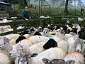 Sheep Pens, West Northdale Farm - geograph.org.uk - 106207.jpg 640 × 482; 66 KB
-
 Sheriff's Pit Shaft - geograph.org.uk - 172593.jpg 640 × 480; 222 KB
-
 Snowdrift and bin - geograph.org.uk - 372571.jpg 640 × 427; 76 KB
-
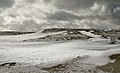 Snowdrifts at Chimney Bank - geograph.org.uk - 373422.jpg 640 × 390; 56 KB
-
 Spaunton Moor looking down Rosedale - geograph.org.uk - 213854.jpg 640 × 480; 120 KB
-
 Spruce trees by Knott road - geograph.org.uk - 319963.jpg 640 × 427; 64 KB
-
 Stile just above High House Farm - geograph.org.uk - 21167.jpg 640 × 480; 68 KB


_-_geograph.org.uk_-_106143.jpg)


_-_geograph.org.uk_-_75191.jpg)


