Category:River Taw
Jump to navigation
Jump to search

river in Devon, United Kingdom  | |||||
| Upload media | |||||
| Instance of | |||||
|---|---|---|---|---|---|
| Location | Devon, South West England, England | ||||
| Length |
| ||||
| Mouth of the watercourse | |||||
| Tributary |
| ||||
 | |||||
Subcategories
This category has the following 6 subcategories, out of 6 total.
B
- Barnstaple Loop Bridge (14 F)
N
- Newbridge Bridge, Devon (6 F)
P
- Pill railway bridge (Devon) (6 F)
T
Media in category "River Taw"
The following 81 files are in this category, out of 81 total.
-
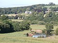
 A bend in the Taw Valley - geograph.org.uk - 102071.jpg 640 × 438; 73 KB
-
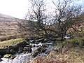
 A bend on the upper Taw - geograph.org.uk - 1740722.jpg 640 × 480; 107 KB
-
 Admiralty Chart No 1160 Barnstaple and Bideford Published 1953.jpg 7,989 × 6,146; 5.8 MB
-

-
 Barnstaple (2022-04-01) 052.jpg 5,568 × 3,712; 15.78 MB
-
 Holy Trinity Church, Barnstaple (4332278877).jpg 3,648 × 2,736; 1.75 MB
-
 Belstone, River Taw, Dartmoor (England).JPG 2,703 × 1,996; 2.36 MB
-
 Bishop's Tawton, the Taw - geograph.org.uk - 488435.jpg 640 × 427; 210 KB
-
 Black Bridge, Umberleigh (2022) down stream side.JPG 1,366 × 910; 680 KB
-
 Black Bridge, Umberleigh (2022) underneath.JPG 1,366 × 910; 660 KB
-
 Black Bridge, Umberleigh (2022) up stream side.JPG 1,366 × 910; 652 KB
-
 Bondleigh Mill, Bondleigh - geograph.org.uk - 35039.jpg 597 × 400; 82 KB
-
 Brushford Bridge on the river Taw as seen from downstream (geograph 1856539).jpg 1,024 × 768; 338 KB
-
 Brushford Ford (geograph 4188091).jpg 3,872 × 2,592; 4.85 MB
-
 ColletonBarton Chulmleigh Devon RiverTawValley.JPG 4,608 × 3,456; 4.37 MB
-
 Eggesford - FGW 150263.jpg 1,024 × 683; 530 KB
-
 Eggesford River Taw bridge (2021) up stream side.JPG 1,366 × 910; 757 KB
-
 Ford on the River Taw - geograph.org.uk - 1484098.jpg 640 × 427; 91 KB
-
 Higher Doomsford Crossing - River Taw - geograph.org.uk - 5771.jpg 640 × 438; 52 KB
-
 Island, River Taw - geograph.org.uk - 668543.jpg 640 × 480; 94 KB
-
 Junction Pool - geograph.org.uk - 13090.jpg 640 × 480; 92 KB
-
 Knack Mine Ford - geograph.org.uk - 1491409.jpg 640 × 427; 95 KB
-
 Ordnance Survey One-Inch Sheet 163 Barnstaple, Published 1946.jpg 8,183 × 9,579; 10.79 MB
-
 Ordnance Survey One-Inch Sheet 163 Barnstaple, Published 1960.jpg 8,282 × 9,945; 11.25 MB
-
 Ordnance Survey One-Inch Sheet 163 Barnstaple, Published 1972.jpg 11,066 × 13,207; 46.11 MB
-
 Ordnance Survey Sheet SS 42 52 Bideford, Published 1969.jpg 14,772 × 7,042; 39.53 MB
-
 Railway Bridge at Umberleigh - August 2011 - panoramio.jpg 2,288 × 1,712; 879 KB
-
 Railway Bridge, Umberleigh - August 2011 - panoramio.jpg 2,288 × 1,712; 900 KB
-
 River Taw - geograph.org.uk - 102105.jpg 640 × 480; 132 KB
-
 River Taw - geograph.org.uk - 1335547.jpg 400 × 533; 409 KB
-
 River Taw - geograph.org.uk - 1741398.jpg 640 × 480; 198 KB
-
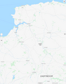 River Taw - map.png 1,076 × 1,371; 242 KB
-
 River Taw above Steeperton.jpg 4,288 × 2,848; 5.85 MB
-
 River Taw at Bailey's Ford - geograph.org.uk - 83469.jpg 640 × 480; 40 KB
-
 River Taw at Bridge Reeve - geograph.org.uk - 1732655.jpg 640 × 480; 105 KB
-
 River Taw at North Tawton - geograph.org.uk - 1719119.jpg 3,648 × 2,048; 2.75 MB
-
 River Taw at Taw Green - geograph.org.uk - 1617730.jpg 480 × 640; 102 KB
-
 River Taw at Taw Green - geograph.org.uk - 1617932.jpg 480 × 640; 110 KB
-
 River Taw at Umberleigh - Aug 2011 - panoramio.jpg 1,712 × 2,288; 1.46 MB
-
 River Taw below Gratleigh Wood - geograph.org.uk - 554750.jpg 640 × 480; 158 KB
-
 River Taw below New Bridge - geograph.org.uk - 578085.jpg 480 × 640; 89 KB
-
 River Taw below New Bridge - geograph.org.uk - 578091.jpg 640 × 480; 87 KB
-
 River Taw from Kingford Bridge - geograph.org.uk - 933353.jpg 640 × 480; 109 KB
-

-
 River Taw in flood - geograph.org.uk - 665121.jpg 640 × 480; 103 KB
-
 River Taw in spate at Smallmarsh - geograph.org.uk - 354962.jpg 640 × 426; 109 KB
-
 River Taw map.png 1,166 × 1,507; 1.69 MB
-
 River Taw meander - geograph.org.uk - 184574.jpg 640 × 480; 119 KB
-
 River Taw meanders in flood, 1 - geograph.org.uk - 665132.jpg 640 × 480; 135 KB
-
 River Taw meanders in flood, 2 - geograph.org.uk - 665139.jpg 640 × 480; 81 KB
-
 River Taw near Chenson Bridge - geograph.org.uk - 83482.jpg 480 × 640; 33 KB
-
 River Taw near Chenson Bridge - geograph.org.uk - 83483.jpg 640 × 480; 44 KB
-
 River Taw near Taw head - geograph.org.uk - 1740620.jpg 640 × 480; 145 KB
-
 River Taw near the sheepfold - geograph.org.uk - 1274252.jpg 640 × 427; 115 KB
-
 River Taw near Westacott Farm - geograph.org.uk - 83475.jpg 640 × 480; 57 KB
-
 River Taw turning below Hawkridge Wood - August 2011 - panoramio.jpg 1,712 × 2,288; 1.16 MB
-
 River Taw, Eggesford station - geograph.org.uk - 1719335.jpg 3,648 × 2,048; 3.32 MB
-
 River Taw, looking towards Hawkridge Wood - Umberleigh - August 2011 - panoramio.jpg 2,288 × 1,712; 794 KB
-
 River Taw, Sticklepath - geograph.org.uk - 1092469.jpg 640 × 480; 154 KB
-
 River Taw, Sticklepath - geograph.org.uk - 1092476.jpg 640 × 480; 156 KB
-
 Riverbank trees - geograph.org.uk - 665116.jpg 640 × 480; 145 KB
-
 Steeperton Gorge - geograph.org.uk - 371522.jpg 640 × 426; 70 KB
-
 Sunset over Barnstaple and the Taw River.jpg 2,448 × 2,448; 1.19 MB
-
 Tarka Line to Barnstaple - geograph.org.uk - 354997.jpg 426 × 640; 139 KB
-
 Taw Head.jpg 4,140 × 2,728; 4.01 MB
-
 Taw River Dartmoor - geograph.org.uk - 62910.jpg 480 × 640; 97 KB
-
 TawstockCourtBySwete.jpg 2,022 × 1,368; 2.26 MB
-
 Tea Time on Taw - geograph.org.uk - 1335558.jpg 640 × 480; 527 KB
-
 Temporary construction bridge - geograph.org.uk - 332942.jpg 640 × 427; 92 KB
-
-
 The River Taw - geograph.org.uk - 1051962.jpg 640 × 426; 88 KB
-
 The River Taw at Umberleigh - geograph.org.uk - 62000.jpg 640 × 406; 87 KB
-
 The Taw at Chapelton - geograph.org.uk - 668456.jpg 640 × 480; 124 KB
-
 The Taw River at Taw Marsh Dartmoor - geograph.org.uk - 62880.jpg 640 × 480; 93 KB
-
 The view upstream from Brushfield Bridge on the river Taw (geograph 1856540).jpg 1,024 × 768; 372 KB
-
 Two boundary stones by the Taw - geograph.org.uk - 1518028.jpg 640 × 427; 89 KB
-
 Umberleigh - GWR 158959 crossing the river.JPG 2,732 × 1,822; 4.25 MB
-
 Umberleigh Bridge - geograph.org.uk - 61998.jpg 640 × 432; 81 KB
-
 Umberleigh Railway Bridge - August 2011 - panoramio.jpg 2,288 × 1,712; 894 KB
-
 Weir on the River Taw - geograph.org.uk - 1518070.jpg 640 × 427; 113 KB
-
 Winkleigh, river Taw near Capper Cross - geograph.org.uk - 335890.jpg 640 × 427; 257 KB


_052.jpg)
.jpg)
.JPG)

_down_stream_side.JPG)
_underneath.JPG)
_up_stream_side.JPG)

.jpg)
.jpg)


_up_stream_side.JPG)


.jpg)


