Category:Ringaskiddy
Jump to navigation
Jump to search
village in Munster, Ireland  | |||||
| Upload media | |||||
| Instance of | |||||
|---|---|---|---|---|---|
| Location | County Cork, Munster, Ireland | ||||
 | |||||
English: Ringaskiddy is a village south of Cork city, in County Cork, Ireland. Located across Cork harbour south from Cóbh, and connected to Cork city by the N28 road the village is now a major ferry port and is one of two free ports in Ireland, the other being in the Shannon area.
Subcategories
This category has only the following subcategory.
N
Media in category "Ringaskiddy"
The following 36 files are in this category, out of 36 total.
-
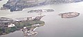 Aerial photograph, Cork Harbour (cropped).jpg 1,082 × 486; 559 KB
-
 Beaufort building.jpg 5,745 × 3,830; 9.04 MB
-
 Black Point - geograph.org.uk - 3666543.jpg 1,024 × 768; 177 KB
-
 Breakwater - geograph.org.uk - 3666526.jpg 1,024 × 768; 134 KB
-
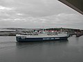
 Brittany Ferries Pont Aven ready to cast off - geograph.org.uk - 3666316.jpg 1,024 × 768; 172 KB
-
 Bunkering Lines - geograph.org.uk - 1849399.jpg 3,452 × 2,298; 746 KB
-
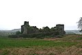 Castle Warren - geograph.org.uk - 1852983.jpg 3,456 × 2,304; 959 KB
-
 Castle Warren Ruin - geograph.org.uk - 1858723.jpg 2,304 × 3,456; 929 KB
-
 Chemical plants seen from Curraghbinny Woods - geograph.org.uk - 5041168.jpg 1,024 × 768; 109 KB
-
 Coast between Black Point and White Point - geograph.org.uk - 3666546.jpg 1,024 × 768; 131 KB
-
 Damaged statue - geograph.org.uk - 2770910.jpg 640 × 480; 82 KB
-
 Ferry Boat Inn - geograph.org.uk - 1849445.jpg 3,390 × 2,202; 1,001 KB
-
 Ferry Terminal building, Port of Cork - geograph.org.uk - 5009118.jpg 1,024 × 768; 139 KB
-
 Haulbowline Island - geograph.org.uk - 3666550.jpg 1,024 × 768; 185 KB
-
 In Ringaskiddy - geograph.org.uk - 4658200.jpg 4,000 × 2,664; 5.48 MB
-
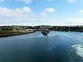 Looking back to Ferry Berths - geograph.org.uk - 3666342.jpg 800 × 600; 85 KB
-
 Near Ringaskiddy - geograph.org.uk - 4658209.jpg 4,000 × 2,664; 4.1 MB
-
 Old Post Office Road - geograph.org.uk - 4658193.jpg 4,000 × 2,664; 4.6 MB
-
 Petroleum Terminal - geograph.org.uk - 3666533.jpg 1,024 × 768; 181 KB
-
 Ringaskiddy Deep Water Berth - geograph.org.uk - 3666339.jpg 1,024 × 768; 131 KB
-
 Ringaskiddy Dockside - geograph.org.uk - 1849382.jpg 3,384 × 2,190; 950 KB
-

-
-
 Ringaskiddy Martello Tower (Cork) - geograph.org.uk - 6560173.jpg 1,024 × 768; 890 KB
-
 Ringaskiddy Terminal - geograph.org.uk - 1856365.jpg 3,456 × 2,304; 945 KB
-
 Road Junction - geograph.org.uk - 4658189.jpg 4,000 × 2,664; 6.05 MB
-
 Secluded beach near Ringaskiddy - geograph.org.uk - 2805642.jpg 640 × 480; 69 KB
-
 Statue, opposite Ringaskiddy ferry port entrance - geograph.org.uk - 3685795.jpg 1,024 × 760; 180 KB
-
 The 2nd Ferry Berth - geograph.org.uk - 3666322.jpg 1,024 × 768; 172 KB
-
 The 2nd Ferry Berth loading ramp - geograph.org.uk - 3666326.jpg 1,024 × 768; 180 KB
-
 The beach at Ringaskiddy - geograph.org.uk - 595345.jpg 640 × 480; 92 KB
-

-
 The National Maritime College of Ireland - geograph.org.uk - 5006756.jpg 1,024 × 768; 172 KB
-
 The Oratory, Ringaskiddy - geograph.org.uk - 5006763.jpg 1,024 × 768; 103 KB
-
 View towards a chemical plant at Ringaskiddy - geograph.org.uk - 5006804.jpg 1,024 × 760; 162 KB
-
 West Channel beach near Ringaskiddy - geograph.org.uk - 594260.jpg 640 × 480; 102 KB
.jpg)


.jpg)
_-_geograph.org.uk_-_6560173.jpg)


