Category:Richmondshire District
Jump to navigation
Jump to search
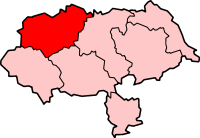
former non-metropolitan district of North Yorkshire, England, UK | |||||
| Upload media | |||||
| Instance of |
| ||||
|---|---|---|---|---|---|
| Location | North Yorkshire, Yorkshire and the Humber, England | ||||
| Capital | |||||
| Legislative body |
| ||||
| Inception |
| ||||
| Dissolved, abolished or demolished date |
| ||||
| Population |
| ||||
| Area |
| ||||
| official website | |||||
 | |||||
Subcategories
This category has the following 108 subcategories, out of 108 total.
- Fields in Richmondshire District (142 F)
A
- Akebar (49 F)
- Arrathorne (67 F)
B
C
- Caldwell, North Yorkshire (67 F)
D
E
- Eppleby (52 F)
G
H
- Harmby (139 F)
- Hutton Hang (42 F)
K
L
M
- Melmerby, Richmondshire (78 F)
N
- Newton Morrell (46 F)
P
R
S
- Scotton, Richmondshire (77 F)
- Stainton, Richmondshire (60 F)
T
- Tunstall, North Yorkshire (73 F)
U
- Uckerby (18 F)
W
- West Layton (38 F)
- Whashton (71 F)
Media in category "Richmondshire District"
The following 42 files are in this category, out of 42 total.
-
Boulder, Surrender Moss - geograph.org.uk - 838917.jpg 640 × 427; 345 KB
-
Bouldershaw House (farm) - geograph.org.uk - 803991.jpg 640 × 480; 192 KB
-
Buttertubs (42033834194).jpg 3,648 × 2,314; 5.56 MB
-
Campsite at Scubba Wath - geograph.org.uk - 1358620.jpg 640 × 427; 128 KB
-
Deer - panoramio (6).jpg 2,666 × 2,592; 1,019 KB
-
Deer - panoramio (7).jpg 2,213 × 2,262; 383 KB
-
DL8 163 VR postbox - panoramio.jpg 3,072 × 1,728; 2.4 MB
-
Earthwork near settlements - geograph.org.uk - 591137.jpg 640 × 480; 101 KB
-
Easby DL10, UK - panoramio.jpg 3,264 × 2,448; 2.77 MB
-
Families and couples only, no groups - geograph.org.uk - 1729003.jpg 518 × 389; 156 KB
-
Farmhouse set back from the B6270 - geograph.org.uk - 1729034.jpg 518 × 389; 163 KB
-
Giant - panoramio.jpg 1,920 × 1,950; 1,009 KB
-
Giant's axe - panoramio.jpg 1,798 × 1,761; 754 KB
-
Green Bridge at Richmond.jpg 3,000 × 1,800; 1.16 MB
-
Keep out^ - geograph.org.uk - 1728996.jpg 518 × 389; 159 KB
-
Maze - panoramio (1).jpg 1,616 × 1,619; 738 KB
-
Muker, UK - panoramio.jpg 3,264 × 2,448; 2.61 MB
-
Old railway goods van - geograph.org.uk - 1361879.jpg 640 × 427; 98 KB
-
Path above the gill - geograph.org.uk - 1016868.jpg 640 × 480; 104 KB
-
Path through the wood - geograph.org.uk - 1016842.jpg 640 × 480; 157 KB
-
Polish Air Crash Memorial Cross , Buckden Pike , N.Yorkshire , 2010 - panoramio.jpg 2,231 × 1,573; 926 KB
-
Richmond Castle Fern (136250645).jpeg 2,048 × 1,151; 379 KB
-
Richmond Castle Flower (136250353).jpeg 2,048 × 1,151; 469 KB
-
Richmondshire UK local election 2011 map.svg 1,425 × 1,148; 668 KB
-
Richmondshire UK local election 2015 map.svg 1,425 × 1,148; 671 KB
-
Richmondshire UK local election 2019 map.svg 1,126 × 794; 348 KB
-
Riverside Road and the River Swale - geograph.org.uk - 1135064.jpg 640 × 426; 68 KB
-
Roe Beck - geograph.org.uk - 769910.jpg 640 × 480; 97 KB
-
Saint Martin's, UK - panoramio.jpg 3,264 × 2,448; 3.06 MB
-
Signs - panoramio (3).jpg 2,250 × 2,159; 506 KB
-
Spanham Scar - geograph.org.uk - 713560.jpg 640 × 480; 113 KB
-
Spanham West Hill - geograph.org.uk - 713729.jpg 640 × 480; 74 KB
-
Stang House - geograph.org.uk - 769826.jpg 640 × 480; 50 KB
-
The road to Feetham - geograph.org.uk - 1729000.jpg 518 × 389; 156 KB
-
Track across The Combs - geograph.org.uk - 713743.jpg 640 × 480; 136 KB
-
Tree - panoramio (24).jpg 2,196 × 2,135; 877 KB
-
Venus - panoramio.jpg 1,578 × 1,541; 412 KB
-
View from the Forbidden Corner - panoramio (1).jpg 4,000 × 2,071; 3 MB
-
View from the Forbidden Corner - panoramio.jpg 4,000 × 2,054; 3.35 MB
-
Wellington Shaft - geograph.org.uk - 1231293.jpg 640 × 426; 100 KB
-
Whitsundale Beck put-in at Ravenseat - geograph.org.uk - 3740216.jpg 4,000 × 2,400; 1.31 MB


