Category:Republic of Ireland photographs taken on 2007-12-11
Jump to navigation
Jump to search
| ← | Tuesday 11 December 2007 | → | ||
| ← | December 2007 | → | ||

Ireland photographs taken on 11 December 2007.
Image files should be categorized here automatically using {{taken on}} template. Direct categorisation is also possible, if automatic is impossible.
Media in category "Republic of Ireland photographs taken on 2007-12-11"
The following 34 files are in this category, out of 34 total.
-
 Ashmount - panoramio.jpg 1,536 × 1,152; 216 KB
-
 Cloghfin Townland - geograph.org.uk - 631747.jpg 640 × 479; 54 KB
-
 Corryarbeg Townland - geograph.org.uk - 631746.jpg 640 × 479; 64 KB
-

-
 Derrykinnigh More - geograph.org.uk - 631772.jpg 640 × 479; 70 KB
-
 Derrykinnigh More - geograph.org.uk - 631776.jpg 640 × 479; 61 KB
-
 Derrykinnigh Townland - geograph.org.uk - 631770.jpg 640 × 479; 74 KB
-
 Derrylea Townland - geograph.org.uk - 631801.jpg 640 × 479; 59 KB
-
 Derrylea Townland - geograph.org.uk - 631804.jpg 640 × 479; 52 KB
-
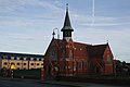 Donabate - St. Patricks RC Church.jpg 640 × 427; 43 KB
-
 Forest near Glen Beg - geograph.org.uk - 631668.jpg 640 × 479; 75 KB
-
 Forestry at Drumferrer - geograph.org.uk - 631664.jpg 640 × 479; 59 KB
-
 Glen Beg - geograph.org.uk - 631676.jpg 640 × 479; 59 KB
-
 Glen Beg - geograph.org.uk - 631679.jpg 640 × 479; 47 KB
-
 Glen More - geograph.org.uk - 631682.jpg 640 × 479; 74 KB
-
 Glen More - geograph.org.uk - 631743.jpg 640 × 479; 46 KB
-
 Glen More Townland - geograph.org.uk - 631740.jpg 640 × 479; 58 KB
-
 Road at Crossnacaldoo - geograph.org.uk - 631672.jpg 640 × 479; 64 KB
-
 Road at Derrykinnigh - geograph.org.uk - 631777.jpg 640 × 479; 60 KB
-
 Road at Drumfernasky - geograph.org.uk - 631786.jpg 640 × 479; 53 KB
-
 Road at Drumferrer - geograph.org.uk - 631663.jpg 640 × 479; 74 KB
-
 Road near Glen Beg - geograph.org.uk - 631669.jpg 640 × 479; 49 KB
-
 Sliabh Beagh Way - geograph.org.uk - 631670.jpg 640 × 313; 45 KB
-

-

-
 Drumfernasky Townland - geograph.org.uk - 631788.jpg 640 × 479; 65 KB
-
 Drumferrer Townland - geograph.org.uk - 631661.jpg 640 × 479; 64 KB
-
 Drumferrer Townland - geograph.org.uk - 631666.jpg 640 × 479; 64 KB
-
 Drumlester Townland - geograph.org.uk - 631792.jpg 640 × 274; 32 KB
-

-
 Eshveragh Townland - geograph.org.uk - 631674.jpg 640 × 479; 58 KB
-
 Knockabeany Townland - geograph.org.uk - 631783.jpg 640 × 479; 85 KB
-
 Mullagh Otra - geograph.org.uk - 631796.jpg 640 × 479; 79 KB
-
 Mullagh Otra Townland - geograph.org.uk - 631799.jpg 640 × 479; 68 KB


