Category:Republic of Ireland photographs taken on 2005-05-27
Jump to navigation
Jump to search

Media in category "Republic of Ireland photographs taken on 2005-05-27"
The following 76 files are in this category, out of 76 total.
-
 3000 (miles-km) to New York - geograph.org.uk - 14551.jpg 640 × 480; 131 KB
-
 A Duncormick Barn - geograph.org.uk - 14608.jpg 640 × 480; 267 KB
-
 Along the clifftops of Tory island - geograph.org.uk - 674015.jpg 640 × 480; 90 KB
-
 An Irish Pub near Duncormick - geograph.org.uk - 14550.jpg 640 × 408; 140 KB
-
 Barn - geograph.org.uk - 14579.jpg 640 × 480; 332 KB
-
 Beach at Saltmills - geograph.org.uk - 14582.jpg 640 × 480; 281 KB
-
 Blackwater River - geograph.org.uk - 14612.jpg 640 × 480; 226 KB
-
 Boarded up Church Window - geograph.org.uk - 14547.jpg 480 × 600; 244 KB
-
 Boats at West Pier Toraig - geograph.org.uk - 539040.jpg 640 × 480; 161 KB
-
 Bridge at Tintern Abbey - geograph.org.uk - 14587.jpg 640 × 480; 332 KB
-
 Bridge over the River at Duncormick - geograph.org.uk - 14537.jpg 640 × 480; 378 KB
-
 Burial Ground and Farm Barn - geograph.org.uk - 14615.jpg 640 × 480; 544 KB
-
 Cave - geograph.org.uk - 370346.jpg 640 × 480; 144 KB
-

-
 Church of Ireland - geograph.org.uk - 14553.jpg 640 × 480; 301 KB
-
 Cliffs of north east Tory Island - geograph.org.uk - 673995.jpg 640 × 480; 101 KB
-
 Cliffs of Toraig - geograph.org.uk - 673969.jpg 640 × 480; 82 KB
-
 Coolhull Castle - geograph.org.uk - 14545.jpg 640 × 480; 216 KB
-
 Derek Hill's hut on Toraig - geograph.org.uk - 673932.jpg 640 × 480; 97 KB
-

-
 Dunbrody Famine Ship (Replica) - geograph.org.uk - 14535.jpg 640 × 480; 143 KB
-
 East Pier Toraig - geograph.org.uk - 357548.jpg 640 × 480; 86 KB
-
 Estuary at Bannow Bay - geograph.org.uk - 14591.jpg 640 × 366; 127 KB
-
 Farm and Barn - geograph.org.uk - 14599.jpg 640 × 411; 151 KB
-
 Farm Building Near Rosslare and Tagoat - geograph.org.uk - 14592.jpg 640 × 366; 115 KB
-
 Farm near Saltmills and Bannow Bay - geograph.org.uk - 14577.jpg 640 × 480; 213 KB
-
 Farmland - geograph.org.uk - 14546.jpg 640 × 480; 265 KB
-
 Farmland - geograph.org.uk - 14572.jpg 640 × 480; 311 KB
-
 Farmland and Countryside - geograph.org.uk - 14570.jpg 640 × 480; 211 KB
-
 Hotel Toraig - geograph.org.uk - 357562.jpg 640 × 480; 118 KB
-
 Inlet east side if Toraig - geograph.org.uk - 674022.jpg 640 × 480; 129 KB
-
 Local Cliff Flora - geograph.org.uk - 14562.jpg 640 × 480; 445 KB
-
 Looking across Bannow Bay - geograph.org.uk - 14590.jpg 640 × 480; 208 KB
-
 Modern Dwelling near Rosslare - geograph.org.uk - 14543.jpg 640 × 480; 216 KB
-
 North shore of Tory island - geograph.org.uk - 674035.jpg 640 × 480; 99 KB
-
 Old Cottage - geograph.org.uk - 14542.jpg 480 × 569; 192 KB
-

-

-
 Rocky coast of Tory Island - geograph.org.uk - 674001.jpg 640 × 480; 111 KB
-
 Silted area - geograph.org.uk - 14593.jpg 640 × 480; 324 KB
-
 Single Storey Modern Dwelling - geograph.org.uk - 14544.jpg 640 × 480; 197 KB
-
 South shoreline Toraig - geograph.org.uk - 673983.jpg 640 × 480; 81 KB
-
 The Anvil Tory Island - geograph.org.uk - 673944.jpg 640 × 480; 48 KB
-
 The Blackwater River - geograph.org.uk - 14611.jpg 640 × 256; 82 KB
-
 The coast road to Wellington Bridge - geograph.org.uk - 14602.jpg 640 × 480; 237 KB
-
 The coast road to Wellington Bridge - geograph.org.uk - 14603.jpg 640 × 480; 192 KB
-
 The Dunbrody Inn, New Ross - geograph.org.uk - 14536.jpg 640 × 480; 212 KB
-
 The estuary at Saltmills - geograph.org.uk - 14589.jpg 640 × 480; 188 KB
-
 Tintern Abbey (Co, Wexford).jpg 640 × 480; 183 KB
-
 Tintern Abbey (Ireland) - geograph.org.uk - 14586.jpg 640 × 480; 181 KB
-
 Tory Road - geograph.org.uk - 673959.jpg 640 × 392; 56 KB
-
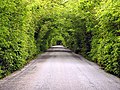 Tree Tunnel - geograph.org.uk - 14600.jpg 640 × 480; 406 KB
-
 Trinity Street, Dublin - geograph.org.uk - 712562.jpg 480 × 640; 95 KB
-
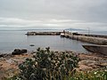 West Pier Toraig - geograph.org.uk - 357555.jpg 640 × 480; 75 KB
-
 Balor's soldiers - geograph.org.uk - 379338.jpg 640 × 480; 100 KB
-
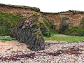 Beach and Cliffs near Bannow Bay - geograph.org.uk - 14557.jpg 640 × 480; 397 KB
-
 Bog Flora at Bannow - geograph.org.uk - 14597.jpg 640 × 480; 387 KB
-
 Cannick on Barrow - geograph.org.uk - 14552.jpg 640 × 480; 196 KB
-
 Coast near Bannow Bay - geograph.org.uk - 14561.jpg 640 × 480; 190 KB
-
 Duncormick Farmland - geograph.org.uk - 14609.jpg 640 × 480; 352 KB
-
 Farm at Bannow Bay - geograph.org.uk - 14594.jpg 640 × 480; 209 KB
-
 Farm Pond - geograph.org.uk - 14601.jpg 640 × 480; 347 KB
-
 Farmland and River - geograph.org.uk - 14576.jpg 640 × 480; 187 KB
-
 Highest point Toraig - geograph.org.uk - 379419.jpg 640 × 480; 106 KB
-
 Houses in Duncormick - geograph.org.uk - 14538.jpg 640 × 480; 406 KB
-
 Pasture in the South of Ireland - geograph.org.uk - 14606.jpg 640 × 480; 257 KB
-
 Pastureland - geograph.org.uk - 14563.jpg 640 × 480; 192 KB
-
 Police Station - geograph.org.uk - 14541.jpg 640 × 480; 186 KB
-
 River at Wellington Bridge - geograph.org.uk - 14604.jpg 640 × 480; 169 KB
-
 Road to Bannow Bay - geograph.org.uk - 14564.jpg 640 × 475; 210 KB
-
 Scabious at cliff edge - geograph.org.uk - 379362.jpg 640 × 480; 146 KB
-
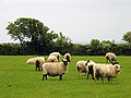
 Sheep Pasture near Grange - geograph.org.uk - 14614.jpg 640 × 480; 295 KB
-
 Thatched Cottage near Bannow Bay - geograph.org.uk - 14558.jpg 640 × 480; 353 KB
-
 The Brandane Inn - geograph.org.uk - 14598.jpg 640 × 480; 168 KB
-
 The Church in Duncormick - geograph.org.uk - 14539.jpg 640 × 480; 203 KB
-
 Toraig - geograph.org.uk - 372425.jpg 640 × 480; 114 KB
_to_New_York_-_geograph.org.uk_-_14551.jpg)


_-_geograph.org.uk_-_14535.jpg)


.jpg)
_-_geograph.org.uk_-_14586.jpg)


