Category:Reinickendorf (district of Berlin)
Jump to navigation
Jump to search
borough of Berlin, Germany | |||||
| Upload media | |||||
| Pronunciation audio | |||||
|---|---|---|---|---|---|
| Instance of | |||||
| Named after | |||||
| Location | Berlin, Germany | ||||
| Head of government | |||||
| Inception |
| ||||
| Population |
| ||||
| Area |
| ||||
| Different from | |||||
| official website | |||||
 | |||||
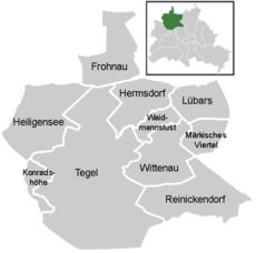
- Deutsch: Bezirk Reinickendorf ist ein Bezirk von Berlin. Für den Ortsteil siehe Berlin-Reinickendorf.
Subcategories
This category has the following 36 subcategories, out of 36 total.
B
F
H
K
L
M
R
T
W
Pages in category "Reinickendorf (district of Berlin)"
This category contains only the following page.
Media in category "Reinickendorf (district of Berlin)"
The following 29 files are in this category, out of 29 total.
-
20240522 xl 1833-Am Rathaus Reinickendorf 3.jpg 4,080 × 3,072; 6.19 MB
-
Das Boot "Moby Dick" an Tegel - geo.hlipp.de - 14131.jpg 640 × 480; 106 KB
-
Ehemaliges Kino "Camera", Reinickendorf.jpg 4,128 × 3,096; 7.11 MB
-
Einwohnerentwicklung von Bezirk Reinickendorf.svg 800 × 400; 53 KB
-
Entenschnabel mit Grenzen und Straßen.jpg 1,500 × 709; 268 KB
-
Flagge Bezirk Reinickendorf.svg 500 × 300; 14 KB
-
Forstamt Tegel - Autobahn 111 - geo.hlipp.de - 32746.jpg 640 × 480; 81 KB
-
Forstamt Tegel - Waldweg - geo.hlipp.de - 32745.jpg 640 × 480; 98 KB
-
Konradshoehe - Moby Dick - geo.hlipp.de - 41675.jpg 640 × 321; 58 KB
-
Luebarser Rundweg (Luebars Circular Path) - geo.hlipp.de - 34186.jpg 640 × 480; 102 KB
-
Moby Dick - geo.hlipp.de - 40506.jpg 685 × 320; 47 KB
-
Nieder Neuendorfer See - Moby Dick - geo.hlipp.de - 41660.jpg 678 × 320; 70 KB
-
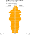
Population pyramid of borough Reinickendorf (DE-2009-12-31).svg 1,060 × 1,230; 6 KB
-
Population pyramid of borough Reinickendorf (DE-2010-12-31).svg 1,060 × 1,230; 6 KB
-
Reinickendorf (8265911313).jpg 3,872 × 2,592; 2.27 MB
-
Reinickendorf (8266977352).jpg 3,872 × 2,592; 2.42 MB
-
Ruppiner Chaussee - Forstamt Tegel - geo.hlipp.de - 32747.jpg 640 × 480; 121 KB
-
Schulgebäude in der Treskowstraßé 1. Bauabschnitt 1902.png 3,353 × 1,701; 3.55 MB
-
Shopping Centre (8266972714).jpg 3,872 × 2,592; 2.29 MB
-
Sprintwiesenteich in Berlin.jpg 4,928 × 3,264; 16.17 MB
-
Tegelort - Pong's China-Restaurant - geo.hlipp.de - 41688.jpg 640 × 480; 115 KB
-
Valentinswerder - geo.hlipp.de - 40504.jpg 640 × 331; 70 KB
-
Valentinswerder - WSP - geo.hlipp.de - 40505.jpg 640 × 480; 76 KB
-
Villa Borsig - geo.hlipp.de - 28805.jpg 640 × 480; 75 KB
-
Waldweg - Frohnau (Woodland Path) - geo.hlipp.de - 32732.jpg 640 × 480; 133 KB


