Category:Reenard
Jump to navigation
Jump to search
townland in Caher, County Kerry, Ireland | |||||
| Upload media | |||||
| Instance of | |||||
|---|---|---|---|---|---|
| Location |
| ||||
 | |||||
English: Reenard is a townland in County Kerry, Ireland. It is located in the deep south on the Iveragh peninsula on the southwest coast of Ireland opposite Valentia Island about 10 miles west of Cahirciveen. Reenard is connected to the Irish road network by a road crossing the N70 national secondary route at Point's Cross.
Media in category "Reenard"
The following 9 files are in this category, out of 9 total.
-
 Kerry Fish, Reenards Point - geograph.org.uk - 6029584.jpg 1,024 × 706; 116 KB
-
 Knight's Town on Valentia Island - geograph.org.uk - 4918168.jpg 620 × 413; 37 KB
-
 Nearing Reenard Point - geograph.org.uk - 5223718.jpg 640 × 480; 53 KB
-
 Old Goods Shed, Reenard - geograph.org.uk - 1009096.jpg 640 × 426; 81 KB
-
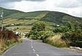 Renard Rd - geograph.org.uk - 6032250.jpg 1,024 × 707; 164 KB
-
 Renard Road - geograph.org.uk - 4549838.jpg 3,648 × 2,736; 3.7 MB
-
 Road from Valentia Ferry - geograph.org.uk - 6032249.jpg 1,024 × 561; 72 KB
-
 Valencia Harbour, Reenard Point - geograph.org.uk - 6029587.jpg 1,024 × 681; 121 KB
-
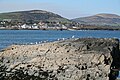 Valentia Island from Renard Point - geograph.org.uk - 783610.jpg 640 × 427; 183 KB


