Category:Redesmouth
Jump to navigation
Jump to search
village in Northumberland, England, UK | |||||
| Upload media | |||||
| Instance of | |||||
|---|---|---|---|---|---|
| Location | Bellingham, Northumberland, North East England, England | ||||
 | |||||
English: Redesmouth is a village in Northumberland, England, just over to the south-east of Bellingham.
Subcategories
This category has the following 2 subcategories, out of 2 total.
L
- Lee Hall, Northumberland (3 F)
R
- Reedsmouth railway station (10 F)
Media in category "Redesmouth"
The following 37 files are in this category, out of 37 total.
-
 After the Snowstorm - geograph.org.uk - 269592.jpg 640 × 432; 56 KB
-
 Border Counties Railway - geograph.org.uk - 1406651.jpg 640 × 427; 92 KB
-

-
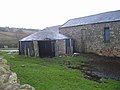 Gin gang 001.jpg 640 × 480; 84 KB
-
 Heugh Clints - geograph.org.uk - 93667.jpg 640 × 258; 54 KB
-
 Houxty Burn (2) - geograph.org.uk - 489432.jpg 640 × 480; 167 KB
-
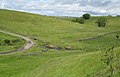
 Pastures and woodland near Redesmouth - geograph.org.uk - 493758.jpg 640 × 480; 91 KB
-
 Rede Bridge - geograph.org.uk - 718681.jpg 640 × 480; 97 KB
-
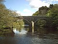 Rede bridge - geograph.org.uk - 726082.jpg 640 × 480; 89 KB
-
 Redesmouth - geograph.org.uk - 1406492.jpg 640 × 359; 59 KB
-
 Snowscene near Sweethope Lough - geograph.org.uk - 266677.jpg 640 × 427; 98 KB
-
 Weir at Rede Bridge - geograph.org.uk - 1250079.jpg 640 × 480; 80 KB
-

-
 Birtley Shields - geograph.org.uk - 1406665.jpg 640 × 359; 91 KB
-
 Buteland - geograph.org.uk - 374260.jpg 640 × 371; 69 KB
-
 Catless Farm - geograph.org.uk - 485816.jpg 640 × 480; 89 KB
-
 Cattle grid east of Longlee Farm - geograph.org.uk - 527721.jpg 640 × 480; 99 KB
-
 Cottage on Wark village green - geograph.org.uk - 489408.jpg 640 × 480; 135 KB
-

-
 Dean Burn - geograph.org.uk - 1406741.jpg 640 × 322; 64 KB
-
 Dean Burn - geograph.org.uk - 1406747.jpg 640 × 374; 74 KB
-
 Dean Burn - geograph.org.uk - 489367.jpg 640 × 480; 152 KB
-
 Dove Cottage, Redesmouth - geograph.org.uk - 314647.jpg 640 × 480; 109 KB
-
 Fawlee Wood - geograph.org.uk - 527710.jpg 640 × 480; 106 KB
-
 Fawley Sike - geograph.org.uk - 486396.jpg 640 × 480; 159 KB
-
 Fishing Lodge, Countesspark Wood - geograph.org.uk - 93669.jpg 640 × 497; 215 KB
-

-
 Footpath to Crossridge - geograph.org.uk - 487926.jpg 480 × 640; 120 KB
-
 Footpath to Longlee Farm - geograph.org.uk - 485846.jpg 640 × 480; 141 KB
-
 Gated road near Ravenshaugh - geograph.org.uk - 485824.jpg 640 × 480; 130 KB
-
 High Carry House - geograph.org.uk - 1406657.jpg 640 × 419; 125 KB
-

-
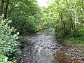 Houxty Burn - geograph.org.uk - 485560.jpg 640 × 480; 169 KB
-
 Kirkfield - geograph.org.uk - 489430.jpg 640 × 480; 142 KB
-
 Lee Hall Cottage - geograph.org.uk - 493861.jpg 640 × 480; 102 KB
-

-


_-_geograph.org.uk_-_489432.jpg)


