Category:Randolph Crescent, Edinburgh
Jump to navigation
Jump to search
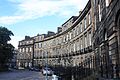
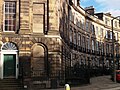
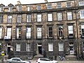
Randolph Crescent is part of Edinburgh's famous New Town. The area was originally part of the estate of the 10th Earl of Murray who fued his 13 acres of land for building an extension of the original New Town of Edinburgh. Randolph Crescent was completed in 1831.
Media in category "Randolph Crescent, Edinburgh"
The following 23 files are in this category, out of 23 total.
-
 1 to 7 Randloph Crescent, Edinburgh.jpg 3,088 × 2,056; 1.44 MB
-
 1-8 RANDOLPH CRESCENT.JPG 2,816 × 2,112; 2.54 MB
-
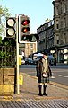 701 Randolph Crescent - Queensferry Street (Edimburg), vestit tradicional.jpg 1,788 × 2,816; 3.37 MB
-
 9 Randolph Crescent, Edinburgh.jpg 2,056 × 3,088; 1.25 MB
-
 9-17 RANDOLPH CRESCENT.JPG 2,112 × 2,816; 2.61 MB
-

-
 East end of Randolph Crescent - geograph.org.uk - 2048126.jpg 1,024 × 768; 279 KB
-
 Edinburgh - Edinburgh, 20 Great Stuart Street - 20140426200716.jpg 2,816 × 1,808; 2.38 MB
-
 French Institute and French Consulate, Edinburgh - geograph.org.uk - 4137314.jpg 3,264 × 2,448; 2.98 MB
-
 French Institute, Randolph Crescent - geograph.org.uk - 3312688.jpg 1,944 × 2,592; 1.23 MB
-
 Front door - geograph.org.uk - 405391.jpg 450 × 640; 102 KB
-
 Old traffic pillar, Randolph Crescent - geograph.org.uk - 1953945.jpg 640 × 480; 110 KB
-
 Randolph Crescent - geograph.org.uk - 5939669.jpg 1,024 × 564; 241 KB
-
 Randolph Crescent - geograph.org.uk - 5941944.jpg 1,024 × 616; 253 KB
-
 Randolph Crescent - geograph.org.uk - 5941947.jpg 1,024 × 697; 303 KB
-
 Randolph Crescent - geograph.org.uk - 6409371.jpg 1,024 × 683; 343 KB
-
 Randolph Crescent 1-8, Edinburgh.JPG 3,264 × 2,448; 2.86 MB
-

-
 Randolph Crescent, Edinburgh - geograph.org.uk - 3509275.jpg 1,280 × 855; 332 KB
-
 Randolph Crescent, Edinburgh - geograph.org.uk - 4201959.jpg 640 × 459; 229 KB
-
 Randolph Crescent, Edinburgh - geograph.org.uk - 6429738.jpg 1,024 × 768; 232 KB
-
 Randolph Crescent, New Town - geograph.org.uk - 1953948.jpg 640 × 480; 100 KB
-
 The Stevenson Sisters (14795902883).jpg 3,648 × 2,736; 2.68 MB


,_vestit_tradicional.jpg)


_(14780669721).jpg)


.jpg)