Category:Rail track diagrams of Nagoya Railroad train stations
Jump to navigation
Jump to search
English: Category of Rail Track map of stations of Nagoya Railroad (Meitetsu)
日本語: 名古屋鉄道の駅配線図画像のカテゴリ
Subcategories
This category has the following 2 subcategories, out of 2 total.
Media in category "Rail track diagrams of Nagoya Railroad train stations"
The following 88 files are in this category, out of 88 total.
-
 Ina2009MP.svg 900 × 300; 47 KB
-
 IwakuraMP.svg 540 × 180; 26 KB
-
 KirayoshidaMP.svg 450 × 330; 26 KB
-
 KoMP.svg 720 × 330; 40 KB
-
 Meitetsunagoyahaisen.png 1,289 × 726; 91 KB
-
 MT-Kitayama Station-Platform 3.png 1,129 × 478; 15 KB
-
 Nishio-guchiMP.svg 840 × 240; 50 KB
-
 Platform layout meitetsunagoya.PNG 175 × 57; 802 bytes
-
 Rail Tracks map Akaike Station.svg 690 × 228; 51 KB
-
 Rail Tracks map Gamagōri Station.svg 570 × 270; 32 KB
-
 Rail Tracks map Kami-Otai Station.svg 690 × 270; 13 KB
-
 Rail Tracks map Kariya Station.svg 810 × 420; 47 KB
-
 Rail Tracks map M-J Ichinomiya Station 2009.svg 866 × 640; 113 KB
-
 Rail Tracks map M-J Kanayama Station.svg 594 × 354; 83 KB
-
 Rail Tracks map Meitetsu Akechi Station.svg 480 × 150; 13 KB
-
 Rail Tracks map Meitetsu Central Japan Int'l Airport Stn.svg 360 × 150; 5 KB
-
 Rail Tracks map Meitetsu Chajo Station.svg 600 × 270; 49 KB
-
 Rail Tracks map Meitetsu Chiryū Station 2020.svg 690 × 420; 56 KB
-
 Rail Tracks map Meitetsu Chiryū Station 20xx(2006).svg 750 × 450; 54 KB
-
 Rail Tracks map Meitetsu Chita Handa Station.svg 480 × 180; 37 KB
-
 Rail Tracks map Meitetsu Egira Station.svg 300 × 90; 11 KB
-
 Rail Tracks map Meitetsu Fuki Station.svg 450 × 240; 38 KB
-
 Rail Tracks map Meitetsu Gifu Station.svg 570 × 450; 33 KB
-
 Rail Tracks map Meitetsu Gorōmaru Signal Box.svg 390 × 107; 13 KB
-
 Rail Tracks map Meitetsu Hashimashiyakusho-mae Station.svg 300 × 90; 9 KB
-
 Rail Tracks map Meitetsu Hekinan Station.svg 330 × 150; 11 KB
-
 Rail Tracks map Meitetsu Hibino Station 2020.svg 270 × 120; 31 KB
-
 Rail Tracks map Meitetsu Higashi Nagoyakō Station.svg 1,290 × 600; 88 KB
-
 Rail Tracks map Meitetsu Higashi-Hazu Station.svg 300 × 90; 7 KB
-
 Rail Tracks map Meitetsu Higashi-Okazaki Station.svg 510 × 180; 16 KB
-
 Rail Tracks map Meitetsu Hotei Station 2022.svg 540 × 240; 44 KB
-
 Rail Tracks map Meitetsu Ichinomiya Station.svg 750 × 270; 8 KB
-
 Rail Tracks map Meitetsu Inuyama Inspection Depot.svg 770 × 540; 114 KB
-
 Rail Tracks map Meitetsu Inuyama Station.svg 720 × 390; 28 KB
-
 Rail Tracks map Meitetsu Jingu-mae Station.svg 476 × 268; 33 KB
-
 Rail Tracks map Meitetsu Kamiiida Station.svg 390 × 90; 16 KB
-
 Rail Tracks map Meitetsu Kanayama Station.svg 570 × 180; 9 KB
-
 Rail Tracks map Meitetsu Kariyashi Station.svg 270 × 90; 8 KB
-
 Rail Tracks map Meitetsu Kasamatsu Station.svg 420 × 330; 20 KB
-
 Rail Tracks map Meitetsu Kashiwamori Station.svg 360 × 150; 12 KB
-
 Rail Tracks map Meitetsu Katahara Station.svg 270 × 120; 28 KB
-
 Rail Tracks map Meitetsu Kitashinkawa Station.svg 360 × 120; 10 KB
-
 Rail Tracks map Meitetsu Komaki Station.svg 450 × 180; 21 KB
-
 Rail Tracks map Meitetsu Kōwa and Kōwaguchi Station.svg 655 × 308; 49 KB
-
 Rail Tracks map Meitetsu Maigi Signal Box.svg 965 × 445; 158 KB
-
 Rail Tracks map Meitetsu Manai Station.svg 1,020 × 360; 63 KB
-
 Rail Tracks map Meitetsu Marunouchi Station.svg 420 × 240; 38 KB
-
 Rail Tracks map Meitetsu Meiden-Chikkō Station.svg 420 × 450; 6 KB
-
 Rail Tracks map Meitetsu Mikakino Station.svg 450 × 150; 13 KB
-
 Rail Tracks map Meitetsu Mikawa Yatsuhashi Station.svg 420 × 90; 10 KB
-
 Rail Tracks map Meitetsu Morikami Station.svg 570 × 150; 21 KB
-
 Rail Tracks map Meitetsu Narumi Station 2009.svg 690 × 180; 21 KB
-
 Rail Tracks map Meitetsu Nishinokuchi Station.svg 450 × 180; 16 KB
-
 Rail Tracks map Meitetsu Nishiura Station.svg 300 × 150; 10 KB
-
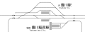
 Rail Tracks map Meitetsu Owari-Seto Station.svg 330 × 150; 18 KB
-
 Rail Tracks map Meitetsu Owariasahi Station.svg 950 × 400; 162 KB
-
 Rail Tracks map Meitetsu Sako Station.svg 660 × 210; 27 KB
-
 Rail Tracks map Meitetsu Sakurai and Minami-Sakurai Station.svg 752 × 241; 57 KB
-
 Rail Tracks map Meitetsu Saya Station.svg 450 × 150; 13 KB
-
 Rail Tracks map Meitetsu Shigehara Station.svg 240 × 120; 9 KB
-
 Rail Tracks map Meitetsu Shin Kani Station.svg 450 × 210; 7 KB
-
 Rail Tracks map Meitetsu Shin Seto Station.svg 480 × 390; 65 KB
-
 Rail Tracks map Meitetsu Shūrakuen Station.svg 540 × 210; 29 KB
-
 Rail Tracks map Meitetsu Sukaguchi Station 2009.svg 870 × 585; 154 KB
-
 Rail Tracks map Meitetsu Sukaguchi Station.svg 630 × 360; 25 KB
-
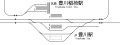
 Rail Tracks map Meitetsu Tagami Station.svg 570 × 150; 41 KB
-
 Rail Tracks map Meitetsu Tokoname Station.svg 450 × 180; 15 KB
-
 Rail Tracks map Meitetsu Toyokawa-inari Station 2.svg 970 × 360; 81 KB
-
 Rail Tracks map Meitetsu Toyokawa-inari Station.svg 240 × 90; 9 KB
-
 Rail Tracks map Meitetsu Toyotashi Station.svg 390 × 150; 10 KB
-
 Rail Tracks map Meitetsu Tsuchihashi Station.svg 600 × 240; 17 KB
-
 Rail Tracks map Meitetsu Umetsubo Station.svg 360 × 210; 14 KB
-
 Rail Tracks map Meitetsu Yoshihama Station.svg 270 × 60; 3 KB
-
 Rail Tracks map Meitetsu Ōe Station.svg 720 × 630; 71 KB
-
 Rail Tracks map Meitetsu Ōtagawa Station 2012(2006).svg 810 × 450; 53 KB
-
 Rail Tracks map Nishi Biwajima Station 2020.svg 1,000 × 1,000; 162 KB
-
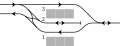
 Rail Tracks map pattern 12A.svg 210 × 90; 12 KB
-
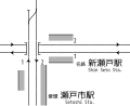
 Rail Tracks map Setoshi Station.svg 540 × 360; 65 KB
-
 Rail Tracks map Toyohashi Station.svg 2,104 × 975; 530 KB
-
 Rail Tracks map Toyokawa Station.svg 970 × 360; 86 KB
-
 Rail Tracks map Unuma and Shin-Unuma Station 2009.svg 872 × 754; 110 KB
-
 Rail Tracks map Yatomi Station.svg 570 × 270; 25 KB
-
 SanageMP.svg 540 × 315; 48 KB
-
 Shin-AnjoMP.svg 510 × 330; 34 KB
-
 ToyoakeMP.svg 750 × 400; 75 KB
-
 TsushimaMP.svg 450 × 270; 17 KB
-
 UtsumiMP.svg 330 × 180; 18 KB
-
 YahagibashiMP.svg 450 × 210; 22 KB


.svg)


.svg)


