Category:Rail track diagrams of JR West train stations
Jump to navigation
Jump to search
Media in category "Rail track diagrams of JR West train stations"
The following 51 files are in this category, out of 51 total.
-
 Aki Aga sta.png 700 × 104; 14 KB
-
 Chiyokawa Ver4.png 145 × 217; 3 KB
-
 Chiyokawa5.png 149 × 221; 3 KB
-
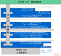
 Fukui-shinkansen-station-layout.png 970 × 210; 6 KB
-
 HarimaKatsuhara Ver2.png 149 × 221; 3 KB
-
 Hikari sta.png 689 × 263; 10 KB
-
 Hikari sta2.png 1,470 × 422; 49 KB
-
 Hiro sta.png 1,446 × 530; 55 KB
-
 Hiroshima Station Platform Map.png 700 × 650; 62 KB
-
 Inari Sta- rail.png 149 × 221; 3 KB
-
 JR Tofukuji Sta (rail).png 149 × 221; 3 KB
-
 JR-Ogura Sta (rail).png 149 × 221; 3 KB
-
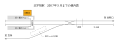
 Kaita.jpg 701 × 303; 30 KB
-
 Kake1.png 693 × 204; 5 KB
-
 Karugahama sta.png 700 × 102; 16 KB
-
 Katamachi Line route.png 800 × 668; 48 KB
-
 Kitauchi Station Railway Track.svg 800 × 300; 5 KB
-
 Kure sta1.png 689 × 251; 12 KB
-
 Kure sta2.png 1,334 × 524; 52 KB
-
 Kure sta2b.png 1,000 × 393; 79 KB
-
 Minamiomine st.jpg 693 × 302; 30 KB
-
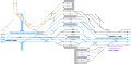
 Osaka-Higashi Line route.png 2,378 × 837; 164 KB
-
 Rail track diagram of JR-W Amagasaki stn ja.svg 900 × 420; 39 KB
-
 Rail Tracks map between Hyogo and Suma-Kaihin-Kouen Station.svg 1,950 × 870; 32 KB
-
 Rail Tracks map Hikata and Kainan Station.svg 760 × 530; 95 KB
-
 Rail Tracks map JR-W Ashiya Station.svg 570 × 300; 16 KB
-
 Rail Tracks map JR-W between Imamiya and Tennoji Station ja.svg 1,770 × 720; 30 KB
-
 Rail Tracks map JR-W between Imamiya and Tennoji Station.svg 1,770 × 720; 29 KB
-
 Rail Tracks map JR-W Kusatsu Station.svg 900 × 330; 28 KB
-
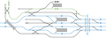
 Rail Tracks map JR-W Kyobashi Station Loop.svg 540 × 120; 15 KB
-
 Rail Tracks map JR-W Kyobashi Stn Tozai Katamachi.svg 510 × 120; 9 KB
-
 Rail Tracks map JR-W Kyoto Station.svg 1,530 × 750; 63 KB
-
 Rail Tracks map JR-W Nishikujo Station.svg 750 × 300; 20 KB
-
 Rail Tracks map JR-W Takatsuki Station.svg 930 × 300; 11 KB
-
 Rail Tracks map JR-W Yamashina Station.svg 660 × 360; 25 KB
-
 Rail Tracks map of Hanaten Station.svg 1,680 × 1,050; 245 KB
-
 Rail Tracks map of Kansai Airport Line.svg 1,680 × 1,950; 579 KB
-
 Rail Tracks map of Kyūhōji Station.svg 1,860 × 870; 188 KB
-
 Saka sta.png 691 × 137; 5 KB
-
 Sandankyo1.png 653 × 164; 3 KB
-
 Shigeyasu st.jpg 656 × 238; 16 KB
-
 Shiomachi sta.jpg 698 × 147; 16 KB
-
 Station Track layout-Shinkansen Hakata Station 2011.png 380 × 200; 10 KB
-
 Takatsu KYOTO Ver2.png 149 × 201; 2 KB
-
 Takatsu KYOTO Ver3.png 149 × 221; 3 KB
-
 Takehara sta.png 1,448 × 292; 23 KB
-
 Tsuruga-Shinkansen-Station-Layout.png 1,200 × 410; 16 KB
-
 Yamatoji Line route.gif 800 × 780; 46 KB
-
 Yoshiura sta.png 694 × 228; 11 KB
-
 Yoshiura sta2.png 750 × 212; 37 KB
-
 今宮-天王寺間配線図.jpg 1,770 × 720; 163 KB


.png)
.png)


