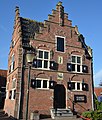
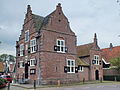
Category:Raadhuis, Grootschermer
Jump to navigation
Jump to search
| Object location | | View all coordinates using: OpenStreetMap |
|---|
 | |||||
| Upload media | |||||
| Instance of | |||||
|---|---|---|---|---|---|
| Location | Grootschermer, Alkmaar, North Holland, Netherlands | ||||
| Street address |
| ||||
| Located on street |
| ||||
| Heritage designation |
| ||||
 | |||||
|
This is a category about rijksmonument number 33091
|
| Address |
|
Media in category "Raadhuis, Grootschermer"
The following 28 files are in this category, out of 28 total.
-
 1639 Dutch house at Grootschermer richly decorated - panoramio.jpg 3,260 × 3,847; 3.76 MB
-
 Zijgevel links - Grootschermer - 20326815 - RCE.jpg 2,632 × 3,616; 1.32 MB
-
 Grootschermer, Scheepjeserf 1.jpg 3,264 × 2,448; 2.87 MB
-
 Grootschermer, the town hall.jpg 2,551 × 1,701; 940 KB
-

-

-

-

-

-

-

-

-

-

-

-
 Ontwerpvignet - Grootschermer - 20411361 - RCE.jpg 872 × 1,200; 150 KB
-
 Overzicht - Grootschermer - 20403376 - RCE.jpg 880 × 1,200; 226 KB
-
 Overzicht - Grootschermer - 20403377 - RCE.jpg 882 × 1,200; 234 KB
-
 Overzicht - Grootschermer - 20403378 - RCE.jpg 888 × 1,200; 233 KB
-
 Overzicht - Grootschermer - 20403379 - RCE.jpg 881 × 1,200; 305 KB
-
 Overzicht raadhuis vanuit het noordoosten - Grootschermer - 20404275 - RCE.jpg 1,200 × 954; 322 KB
-

-

-

-
 Overzicht voorgevel - Grootschermer - 20326428 - RCE.jpg 894 × 1,200; 208 KB
-

-
 Raadhuis, gezien vanuit het zuiden - Grootschermer - 20403934 - RCE.jpg 952 × 1,200; 241 KB
-
 Voormalig stadhouderlijk hof, voorgevel - Leeuwarden - 20381397 - RCE.jpg 867 × 1,200; 249 KB


