Category:Puits des Combes (La Ricamarie)
Jump to navigation
Jump to search
|
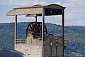
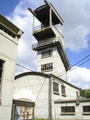
This building is inscrit au titre des monuments historiques de la France. It is indexed in the base Mérimée, a database of architectural heritage maintained by the French Ministry of Culture, under the reference PA42000018
|
Héritage industriel
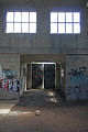
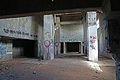
[edit]English: While waiting to be overtaked by urbanization of the industrial area, the mine shaft of the Combes, in state of abandonment, is degrading slowly.
Español: Mientras esperando de ser superado por la urbanización de la zona industrial, el pozo de las Combes, al estado de abandono, esta degradando lentamente.
Français : En attendant d' être rattrapé par l' urbanisation de la zone industielle, le puits des Combes, à l' état d' abandon, se dégrade lentement.
| Object location | | View all coordinates using: OpenStreetMap |
|---|
mine in France  | |||||
| Upload media | |||||
| Instance of | |||||
|---|---|---|---|---|---|
| Location | La Ricamarie, canton of Le Chambon-Feugerolles | ||||
| Street address |
| ||||
| Heritage designation |
| ||||
 | |||||
Media in category "Puits des Combes (La Ricamarie)"
The following 27 files are in this category, out of 27 total.
-
 2014 - Puits des Combes 01.JPG 6,000 × 4,000; 9.66 MB
-
 2014 - Puits des Combes 02.JPG 6,000 × 4,000; 10.25 MB
-
 2014 - Puits des Combes 03.JPG 6,000 × 4,000; 10 MB
-
 2014 - Puits des Combes 04.JPG 8,192 × 1,856; 7.19 MB
-
 2014 - Puits des Combes 05.JPG 4,912 × 3,264; 3.91 MB
-
 2014 - Puits des Combes 06.JPG 4,000 × 6,000; 12.77 MB
-
 2014 - Puits des Combes 07.JPG 4,912 × 3,264; 8.47 MB
-
 2014 - Puits des Combes 08.JPG 6,000 × 4,000; 9.31 MB
-
 2014 - Puits des Combes 09.JPG 6,000 × 4,000; 7.91 MB
-
 2014 - Puits des Combes 10.JPG 6,000 × 4,000; 13.09 MB
-
 2014 - Puits des Combes 11.JPG 4,000 × 6,000; 7.01 MB
-
 2014 - Puits des Combes 12.JPG 4,000 × 6,000; 11.94 MB
-
 2014 - Puits des Combes 13.JPG 6,000 × 4,000; 14.7 MB
-
 2014 - Puits des Combes 14.JPG 4,000 × 6,000; 18.42 MB
-
 2014 - Puits des Combes 15.JPG 6,000 × 4,000; 14.15 MB
-
 2014 - Puits des Combes 16.JPG 6,000 × 4,000; 11.98 MB
-
 2014 - Puits des Combes 17.JPG 6,000 × 4,000; 14.26 MB
-
 La Ricamarie-Carreau du Puits des Combes-20110406.jpg 4,272 × 2,848; 3.75 MB
-
 La Ricamarie-Puits des Combes-20110406.jpg 4,272 × 2,848; 2.37 MB
-
 Puit de mine abandonné.jpg 2,000 × 3,008; 2.96 MB
-
 Puit des combes sous le givre - panoramio.jpg 3,072 × 2,304; 1.55 MB
-
 Puits des Combes de La Ricamarie mine de la Loire.jpg 6,061 × 4,041; 19.67 MB
-
 Puits des Combes de La Ricamarie.jpg 5,917 × 3,979; 17.56 MB
-
 PUITS DES COMBES.jpg 3,648 × 2,736; 4.27 MB
-
 Puitsdescombes.png 2,592 × 1,944; 5.11 MB
-
 Puitsdescombes2.png 595 × 794; 697 KB
-
 Puitsdescombesgénérale.png 794 × 595; 729 KB


