Category:Public footpaths in the Vale of Glamorgan
Jump to navigation
Jump to search
Subcategories
This category has the following 4 subcategories, out of 4 total.
Media in category "Public footpaths in the Vale of Glamorgan"
The following 60 files are in this category, out of 60 total.
-
 Aberthin, South Wales - geograph.org.uk - 368613.jpg 640 × 467; 96 KB
-
 Autumn in Cwm Col-Huw.jpg 5,752 × 3,835; 12.58 MB
-
 Boating Lake's Western Shore - geograph.org.uk - 1932935.jpg 1,200 × 1,600; 430 KB
-
 Bridge and footpath over the Afon Alun - geograph.org.uk - 1203603.jpg 640 × 480; 198 KB
-
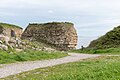
 Castell Talyfan Footpath - geograph.org.uk - 490799.jpg 640 × 480; 303 KB
-
 Cliffs at Rhoose Point (2).jpg 5,682 × 3,788; 13.91 MB
-
 Cosmeston Lakes Country Park, July 2023 02.jpg 6,000 × 4,000; 13.19 MB
-
 Cosmeston Lakes Country Park, July 2023 03.jpg 5,959 × 3,352; 12.06 MB
-
 Cosmeston Lakes Country Park, July 2023 04.jpg 5,674 × 3,651; 9.72 MB
-

-
 Footpath - seemingly well-trodden^ - geograph.org.uk - 468498.jpg 640 × 480; 104 KB
-
 Footpath and fields near The Herberts (geograph 2764698).jpg 4,000 × 3,000; 2.95 MB
-
 Footpath beside the sailing club - Sully - geograph.org.uk - 1480647.jpg 640 × 425; 102 KB
-
 Footpath from Marine Parade to the Esplanade, Penarth - geograph.org.uk - 1952146.jpg 3,296 × 2,472; 1.87 MB
-
 Footpath on Nell's Point - geograph.org.uk - 1888063.jpg 480 × 640; 69 KB
-

-
 Footpath to Rhoose Point.jpg 6,000 × 4,000; 13.4 MB
-
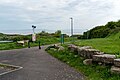
 Footpaths at Rhoose Point.jpg 5,923 × 3,949; 16.29 MB
-
 Path alongside wheat field (geograph 7220932).jpg 3,930 × 2,948; 4.33 MB
-
 Path around Nell's Point - geograph.org.uk - 5425397.jpg 5,202 × 3,465; 4.23 MB
-
 Path at Cosmeston - geograph.org.uk - 1583152.jpg 640 × 480; 113 KB
-
 Path to Friars Point, Barry Island - geograph.org.uk - 1916890.jpg 640 × 552; 74 KB
-
 Path to the beach at Dams Bay, Rhoose.jpg 5,927 × 3,951; 20.82 MB
-

-
 Stone stile on footpath to Llantwit Major.jpg 750 × 500; 122 KB
-
 The Esplanade, Penarth - geograph.org.uk - 1234765.jpg 480 × 640; 69 KB
-
 Traditional Glamorgan Stone Stile - geograph.org.uk - 288820.jpg 480 × 640; 164 KB
-
 Footpath above Pant-y-cwcw Wood - geograph.org.uk - 551574.jpg 640 × 480; 87 KB
-

-
 Footpath at Wern Ddu - geograph.org.uk - 457349.jpg 480 × 640; 393 KB
-
 Footpath below Bal-Mawr - geograph.org.uk - 704146.jpg 639 × 479; 182 KB
-

-
 Footpath from Cwmcarn to Twmbarlwm - geograph.org.uk - 423329.jpg 640 × 480; 128 KB
-
 Footpath from Parc Cwm Deri - geograph.org.uk - 625367.jpg 640 × 477; 120 KB
-
 Footpath heading South, past Newton - geograph.org.uk - 493272.jpg 640 × 480; 87 KB
-
 Footpath junction in Woolpitch Wood - geograph.org.uk - 505057.jpg 640 × 480; 159 KB
-
 Footpath junction near Pen y Pant - geograph.org.uk - 653090.jpg 640 × 480; 120 KB
-

-

-
 Footpath leading to Castle Farm, Usk - geograph.org.uk - 600834.jpg 640 × 480; 36 KB
-
 Footpath Marker post - geograph.org.uk - 480473.jpg 639 × 468; 90 KB
-
 Footpath or stream^ - geograph.org.uk - 625743.jpg 640 × 477; 122 KB
-
 Footpath past Cefn Bach - geograph.org.uk - 624738.jpg 640 × 477; 95 KB
-
 Footpath to Aberedw - geograph.org.uk - 694059.jpg 620 × 452; 160 KB
-
 Footpath to Blaen-waun-ganol - geograph.org.uk - 1432066.jpg 640 × 480; 89 KB
-
 Footpath to Chatham - geograph.org.uk - 625756.jpg 640 × 477; 114 KB
-
 Footpath to Llanishen (2.3Km) - geograph.org.uk - 504947.jpg 640 × 480; 138 KB
-
 Footpath to the Virtuous Well - geograph.org.uk - 481164.jpg 640 × 434; 87 KB
-
 Footpath to Twmbarlwm - geograph.org.uk - 423330.jpg 480 × 640; 143 KB
-
 Footpath towards the Nant yr Hiddl - geograph.org.uk - 642555.jpg 640 × 480; 61 KB
-
 Footpath washed out - geograph.org.uk - 1425691.jpg 425 × 640; 103 KB
-
 Footpath, near Cefn Lla Farm - geograph.org.uk - 468798.jpg 640 × 480; 193 KB
-

-
 Path around Bal-Mawr - geograph.org.uk - 704153.jpg 639 × 479; 196 KB
-
 Path east from Llechwedd-mawr - geograph.org.uk - 702472.jpg 640 × 423; 84 KB
-
 Path or stream^ - geograph.org.uk - 704103.jpg 639 × 479; 279 KB
-
 Path to Capel-y-Ffin - geograph.org.uk - 439287.jpg 640 × 480; 70 KB
-
 Path to Rhyscog - geograph.org.uk - 693231.jpg 639 × 479; 208 KB
-
 Path to the Sea - geograph.org.uk - 428181.jpg 640 × 480; 92 KB
-
 Path towards Loxidge Tump - geograph.org.uk - 438321.jpg 640 × 480; 102 KB


.jpg)


.jpg)


.jpg)


_-_geograph.org.uk_-_504947.jpg)


