Category:Prairie Pothole Region
Jump to navigation
Jump to search
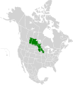
English: The Prairie Pothole Region (PPR) — an area of the northern shortgrass Great Plains and the midgrass and tallgrass prairies in the Canadian Prairies provinces and the upper Midwestern United States.
- The PPR region contains thousands of shallow wetlands known as potholes.
geographic area in North America | |||||
| Upload media | |||||
| Instance of | |||||
|---|---|---|---|---|---|
| Location |
| ||||
 | |||||
Subcategories
This category has the following 3 subcategories, out of 3 total.
D
K
W
Media in category "Prairie Pothole Region"
The following 33 files are in this category, out of 33 total.
-
Prairie Pothole Map.svg 1,712 × 1,992; 343 KB
-
A Storm Passes Over the North Dakota Prairie (28021109124).jpg 6,000 × 4,000; 1.06 MB
-
A Storm Passes Over the North Dakota Prairie (28022112873).jpg 6,000 × 4,000; 2.05 MB
-
American White Pelicans Cooperative Feeding (36949593530).jpg 5,267 × 2,216; 1.65 MB
-
Baird's Sparrow (25865756586) (cropped).jpg 2,210 × 1,712; 261 KB
-
Baird's Sparrow (25865756586).jpg 3,912 × 2,847; 708 KB
-
Barringer-Arial.jpg 319 × 239; 12 KB
-
Dakota Grassland Conservation Area.jpg 550 × 328; 58 KB
-
Filipendula rubra inflorescence.JPG 2,845 × 3,730; 3.67 MB
-
Large pothole in Minnesota.jpg 3,000 × 1,993; 562 KB
-
Map-of-the-Prairie-Pothole-Region-of-the-United-States-and-Canada.jpg 850 × 848; 140 KB
-
Missouri Coteau (656541298).jpg 1,024 × 768; 476 KB
-
North Dakota Native Prairie (32811662943).jpg 3,000 × 2,000; 1.47 MB
-
North Dakota Sheet Water (33999925805).jpg 6,000 × 4,000; 2.6 MB
-
Plains and Prairie Potholes LCC (14245747154).jpg 3,456 × 3,456; 6.06 MB
-
Prairie East of Chase Lake National Wildlife Refuge, North Dakota (28022098683).jpg 5,509 × 3,676; 1.81 MB
-
Prairie pothole (8539505411).jpg 1,024 × 611; 495 KB
-
Prairie Pothole Landscape Lake Andes Wetland Management District South Dakota.jpg 8,048 × 3,920; 9.5 MB
-
Prairie Pothole Landscape South Dakota - 53106527617.jpg 6,000 × 4,000; 5.81 MB
-
Prairie Pothole Landscape South Dakota.jpg 6,000 × 4,000; 5.5 MB
-
Prairie pothole wetland.jpg 3,000 × 1,972; 320 KB
-
Prairie Pothole Wetlands.jpg 1,043 × 737; 637 KB
-
Prairie pothole.jpg 3,000 × 1,970; 564 KB
-
PrairiePotholeRegionMap.gif 295 × 302; 5 KB
-
Rancher and son.jpg 1,600 × 1,143; 681 KB
-
Sharp-Tailed Grouse (25406967553).jpg 2,824 × 1,762; 998 KB
-
Sharp-Tailed Grouse (25759427000).jpg 2,192 × 1,431; 476 KB
-
Sharp-Tailed Grouse (25842987340).jpg 4,320 × 2,997; 1.06 MB
-
Sharp-Tailed Grouse (25842990710).jpg 5,356 × 3,386; 1.45 MB
-
Sharp-Tailed Grouse (26023314502).jpg 5,087 × 2,610; 1.21 MB
-
Sharp-Tailed Grouse (26089894256) (cropped).jpg 1,924 × 1,554; 262 KB
-
Sharp-Tailed Grouse (26089894256).jpg 4,264 × 2,942; 1,007 KB
Categories:
- Great Plains
- Geography of the North-Central United States
- Wetlands of Canada
- Wetlands of the United States
- Geography of North Dakota
- Geography of South Dakota
- Geography of Iowa
- Geography of Minnesota
- Geography of Montana
- Geography of Alberta
- Geography of Manitoba
- Geography of Saskatchewan
- Giants kettles in the United States


