Category:Pontlottyn
Jump to navigation
Jump to search
village in Wales  | |||||
| Upload media | |||||
| Instance of | |||||
|---|---|---|---|---|---|
| Location | Caerphilly County Borough, Wales | ||||
 | |||||
Cymraeg: Pentref yng Nghwm Rhymni ym mwrdeisdref sirol Caerffili yw Pontlotyn (Saesneg: Pontlottyn). Saif ar y briffordd A469, fymryn i'r de-orllewin o Rhymni.
English: Pontlottyn is a village located in the county borough of Caerphilly, within the historic county boundaries of Glamorgan, Wales, United Kingdom. It is sited just to the south of Rhymney, and to the west of the Rhymney River. Pontlottyn has a train Station, post office, 4 fast food establishments, general shops (serving convenience and specialist goods), local cafes, 3 hairdressers and 3 pubs with some serving food. The village also has a local community centre which contains a library with computer facilites.
Subcategories
This category has the following 3 subcategories, out of 3 total.
P
- St Tyfaelog's, Pontlottyn (5 F)
- Pontlottyn railway station (5 F)
- Pontlottyn Viaduct (6 F)
Media in category "Pontlottyn"
The following 47 files are in this category, out of 47 total.
-
 1-5 Fairview Terrace, Pontlottyn - geograph.org.uk - 3420055.jpg 640 × 509; 83 KB
-
 37425 at Pontlottyn - geograph.org.uk - 343156.jpg 640 × 443; 130 KB
-
 A Pontlottyn garage - geograph.org.uk - 3424027.jpg 640 × 441; 63 KB
-

-
 Activity in Parc Cwm Darren - geograph.org.uk - 625353.jpg 640 × 477; 101 KB
-
 Beware of the bull - geograph.org.uk - 625464.jpg 640 × 477; 153 KB
-
 Brewer Street, Pontlottyn - geograph.org.uk - 1161080.jpg 640 × 480; 114 KB
-
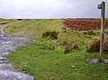 Bridleway across the common - geograph.org.uk - 625575.jpg 640 × 477; 87 KB
-
 Cal White, Pontlottyn - geograph.org.uk - 3425160.jpg 640 × 444; 71 KB
-

-

-

-
-
 Common dumping ground - geograph.org.uk - 625570.jpg 640 × 477; 134 KB
-
 Descent to Groes-faen - geograph.org.uk - 625446.jpg 640 × 477; 125 KB
-
 Disused Police Station, Pontlottyn - geograph.org.uk - 1152573.jpg 640 × 480; 66 KB
-
 Disused Police Station, Pontlottyn - geograph.org.uk - 533485.jpg 640 × 480; 93 KB
-
 Elim Community Church, Pontlottyn - geograph.org.uk - 1074191.jpg 640 × 480; 102 KB
-
 Greenfield Street, Pontlottyn - geograph.org.uk - 1074185.jpg 640 × 480; 112 KB
-

-
 Grid across Fochriw Road east of Fochriw - geograph.org.uk - 5902177.jpg 1,024 × 768; 175 KB
-
 Hillside above Pontlottyn - geograph.org.uk - 2492010.jpg 640 × 480; 99 KB
-
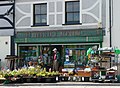 Howard Jones Hardware Stores, Pontlottyn - geograph.org.uk - 535223.jpg 640 × 468; 104 KB
-
 Merchant Street, Pontlottyn - geograph.org.uk - 3013889.jpg 640 × 480; 105 KB
-

-
 Old Police Court - geograph.org.uk - 1054618.jpg 640 × 480; 68 KB
-
 Police Court, Pontlottyn - geograph.org.uk - 533502.jpg 480 × 640; 90 KB
-
 Pontlottyn and Class 47.jpg 1,290 × 860; 210 KB
-
 Pontlottyn Square - geograph.org.uk - 2927750.jpg 3,008 × 2,000; 1.8 MB
-
 Reform Street, Pontlottyn - geograph.org.uk - 1161096.jpg 640 × 480; 121 KB
-
 SE boundary of Pontlottyn - geograph.org.uk - 3423823.jpg 640 × 480; 100 KB
-
 Sheds and compound above Pontlottyn - geograph.org.uk - 3135697.jpg 640 × 480; 85 KB
-
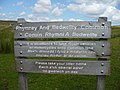 Sign onto Rhymney and Bedwellty Common - geograph.org.uk - 499800.jpg 640 × 480; 278 KB
-
 Southend Terrace, Pontlottyn (1) - geograph.org.uk - 1161093.jpg 640 × 479; 88 KB
-
 Southend Terrace, Pontlottyn (2) - geograph.org.uk - 1161099.jpg 640 × 480; 95 KB
-
 The A469 heads out of Pontlottyn - geograph.org.uk - 3423781.jpg 640 × 582; 129 KB
-
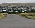
 View of Pontlottyn and Rhymney - geograph.org.uk - 545173.jpg 640 × 480; 202 KB
-
 Western boundary of Pontlottyn - geograph.org.uk - 5902251.jpg 1,024 × 766; 203 KB
-
 Anticipation of a view - geograph.org.uk - 625459.jpg 640 × 477; 112 KB
-
 Bryn Pyllog - geograph.org.uk - 484298.jpg 640 × 480; 84 KB
-
 Coed Deri Newydd - geograph.org.uk - 625374.jpg 640 × 477; 132 KB
-
 Cwm Darren Park, Deri - geograph.org.uk - 534268.jpg 640 × 359; 94 KB
-
 Descent to Groes-faen - geograph.org.uk - 625469.jpg 640 × 462; 99 KB
-
 Duffryn House, Bargoed - geograph.org.uk - 429717.jpg 480 × 640; 117 KB
-
 Edge of the common - geograph.org.uk - 625535.jpg 640 × 465; 79 KB
-
 Footpath from Parc Cwm Deri - geograph.org.uk - 625367.jpg 640 × 477; 120 KB
-
 Footpath past Cefn Bach - geograph.org.uk - 624738.jpg 640 × 477; 95 KB


_-_geograph.org.uk_-_1161093.jpg)
_-_geograph.org.uk_-_1161099.jpg)


