Category:Pont médiéval de Saurier
Jump to navigation
Jump to search
| Object location | | View all coordinates using: OpenStreetMap |
|---|
|
This building is classé au titre des monuments historiques de la France. It is indexed in the base Mérimée, a database of architectural heritage maintained by the French Ministry of Culture, under the reference PA00092406
|
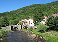
Français : Pont médiéval du XVe siècle sur la Couze Pavin à Saurier, Puy-de-Dôme (Auvergne, France).
bridge in France  | |||||
| Upload media | |||||
| Instance of | |||||
|---|---|---|---|---|---|
| Location | Saurier, canton of Champeix | ||||
| Heritage designation |
| ||||
 | |||||
Media in category "Pont médiéval de Saurier"
The following 16 files are in this category, out of 16 total.
-
 Pont médiéval de Saurier qui enjambe la cause Pavin photo n°6.jpg 4,272 × 2,848; 3.52 MB
-
 Saurier - Pont médiéval (août 2021).jpg 4,032 × 3,016; 4.5 MB
-
 Saurier - Pont médiéval - JPG1.jpg 1,600 × 1,200; 2.1 MB
-
 Saurier - Pont médiéval - JPG2.jpg 1,573 × 1,152; 1.71 MB
-
 Saurier Pont médiéval1.JPG 2,560 × 1,920; 1.83 MB
-
 Saurier Pont médiéval10.JPG 2,560 × 1,920; 1.84 MB
-
 Saurier Pont médiéval11.JPG 2,560 × 1,920; 1.88 MB
-
 Saurier Pont médiéval12.JPG 2,560 × 1,920; 3.7 MB
-
 Saurier Pont médiéval2.JPG 2,560 × 1,920; 1.82 MB
-
 Saurier Pont médiéval3.JPG 2,526 × 1,778; 1.89 MB
-
 Saurier Pont médiéval4.JPG 2,560 × 1,920; 1.87 MB
-
 Saurier Pont médiéval5.JPG 2,560 × 1,920; 1.85 MB
-
 Saurier Pont médiéval6.JPG 2,560 × 1,920; 1.9 MB
-
 Saurier Pont médiéval7.JPG 2,560 × 1,920; 1.87 MB
-
 Saurier Pont médiéval8.JPG 2,560 × 1,920; 1.86 MB
-
 Saurier Pont médiéval9.JPG 2,560 × 1,920; 1.81 MB

.jpg)


