Category:Photos of New Zealand by the Terra (satellite) MODIS
Jump to navigation
Jump to search
Media in category "Photos of New Zealand by the Terra (satellite) MODIS"
The following 43 files are in this category, out of 43 total.
-
 Atmospheric gravity waves off South Island, New Zealand (5300585845).jpg 2,600 × 3,400; 661 KB
-
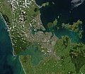
 Auckland isthmus.arp.375pix (cropped).jpg 323 × 229; 14 KB
-
 Auckland.arp.750pix (cropped to Hauraki Plains).jpg 324 × 329; 23 KB
-
 Auckland.arp.750pix (cropped).jpg 323 × 279; 17 KB
-
 Auckland.arp.750pix.jpg 1,144 × 988; 147 KB
-
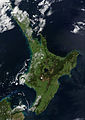
 Cloud Bank over New Zealand's North Island (MODIS).jpg 2,407 × 1,819; 453 KB
-
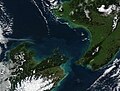 Cook Strait, New Zealand (MODIS 2019-06-06).jpg 2,082 × 1,573; 1.01 MB
-
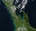
 Coromandel.arp.375pix.jpg 570 × 404; 38 KB
-
 Hatepe.North.Island.NZ.jpg 2,380 × 3,368; 1.21 MB
-
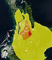
 Lake taupo landsat & volcanic features.jpg 619 × 743; 132 KB
-
 Lake taupo landsat volcanic features vents.jpg 1,102 × 948; 277 KB
-
 Mangakino.Caldera.Rift.Zone.North.Island.NZ.jpg 1,302 × 1,506; 449 KB
-
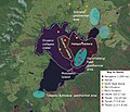
 Map.Hauraki.Rift.Faults.North.Island.NZ.jpg 1,302 × 1,506; 545 KB
-
 Maroa.Caldera.Rift.Zone.North.Island.NZ.jpg 1,302 × 1,506; 544 KB
-
 Motuihe Island.jpg 536 × 384; 51 KB
-
 New Zealand (MODIS 2015-05-11).jpg 4,600 × 5,800; 5.04 MB
-
 New Zealand (MODIS 2015-08-06).jpg 4,600 × 5,800; 6.02 MB
-
 New Zealand (MODIS 2015-12-29).jpg 2,430 × 1,794; 1.48 MB
-
 New Zealand (MODIS 2018-05-07).jpg 3,300 × 2,541; 1.4 MB
-
 New Zealand (MODIS 2020-12-21).jpg 4,141 × 3,533; 1.41 MB
-
 New Zealand 23 October 2002.jpg 4,200 × 5,600; 2.83 MB
-
 NewZealand.A2002296.2220.250m North Island crop.jpg 2,380 × 3,368; 1,008 KB
-
 North.island.arp.750pix.jpg 750 × 1,033; 68 KB
-
 Nzealand tmo 2008004 lrg.jpg 2,400 × 1,800; 515 KB
-
 Ohakuri.Caldera.Rift.Zone.North.Island.NZ.jpg 1,302 × 1,506; 547 KB
-
 Ohakuri.Rotorua.Paired.Eruptions.Rift.Zone.North.Island.NZ.jpg 1,302 × 1,506; 558 KB
-
 Oruanui.North.Island.NZ.jpg 2,380 × 3,368; 1.18 MB
-
 Paeroa-Ngapouri-Rotomahana Faults.jpg 762 × 957; 280 KB
-
 Rift.Zones.North.Island.NZ.jpg 1,302 × 1,506; 530 KB
-
 Rotorua Eruption.jpg 1,302 × 1,506; 464 KB
-
 Satellite image of New Zealand in December 2002.jpg 4,400 × 5,800; 3.39 MB
-
 Severe Tropical Cyclone Gabrielle (MODIS).jpg 4,334 × 3,359; 1.18 MB
-
 Snow and Fog on New Zealand's South Island (MODIS).jpg 1,672 × 1,402; 1.26 MB
-
 Snow on South Island, New Zealand (MODIS 2017-08-11).jpg 3,000 × 3,800; 2.5 MB
-
 South Island blizzard 2003.jpg 2,600 × 3,400; 1.46 MB
-
 South Island, New Zealand (MODIS 2018-08-02).jpg 4,253 × 3,330; 2.46 MB
-
 South Island, New Zealand (MODIS 2018-09-10).jpg 3,765 × 2,614; 1.35 MB
-
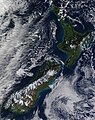
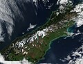
 Southern Alps, South Island, New Zealand (MODIS).jpg 2,024 × 1,714; 493 KB
-
 Springtime on New Zealand's South Island (MODIS 2021-10-23).jpg 3,100 × 2,387; 2.72 MB
-
 Stewart Island.jpg 330 × 393; 20 KB
-
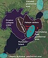
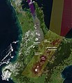
 VolcanicFeatures.North.Island.NZ.jpg 1,302 × 1,506; 576 KB
-
 Whakamaru.Eruption.jpg 1,100 × 1,450; 472 KB
-
 Winter in the Southern Alps (MODIS).jpg 4,353 × 3,416; 1.65 MB
.jpg)
.jpg)
.jpg)
.jpg)

.jpg)
.jpg)


.jpg)
.jpg)
.jpg)
.jpg)
.jpg)


.jpg)
.jpg)
.jpg)

.jpg)
.jpg)
.jpg)
.jpg)


.jpg)