Category:Photographs by Coen Temminck Groll in Sri Lanka
Jump to navigation
Jump to search
Media in category "Photographs by Coen Temminck Groll in Sri Lanka"
The following 110 files are in this category, out of 110 total.
-
 Bouwsel met geveltop en drie poorten - 20652913 - RCE.jpg 1,200 × 1,199; 316 KB
-
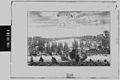
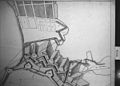
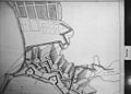
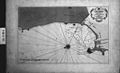 Haven van Colombo, eind 18de eeuw - 20651134 - RCE.jpg 1,200 × 730; 265 KB
-
 Historische plattegrond met omgeving, linker deel boven - 20651121 - RCE.jpg 1,200 × 877; 241 KB
-
-
 Historische plattegrond met omgeving, linker deel onder - 20651119 - RCE.jpg 1,200 × 865; 226 KB
-
-
 Historische plattegrond met omgeving, rechter deel boven - 20651120 - RCE.jpg 1,200 × 876; 234 KB
-
-
 Historische plattegrond met omgeving, rechter deel onder - 20651118 - RCE.jpg 1,200 × 874; 242 KB
-

-
 Historische plattegrond van Colombo, gedeelte links onder - 20651128 - RCE.jpg 1,200 × 883; 344 KB
-
 Historische plattegrond van Colombo, gedeelte rechts boven - 20651127 - RCE.jpg 1,200 × 883; 335 KB
-
 Historische plattegrond van Colombo, gedeelte rechts onder - 20651129 - RCE.jpg 1,200 × 875; 343 KB
-
 Historische plattegrond van Colombo, stad en wijde omgeving - 20651126 - RCE.jpg 1,200 × 854; 342 KB
-
 Historische plattegrond, linker deel boven - 20651117 - RCE.jpg 1,200 × 899; 339 KB
-
 Hoofdstraat met gebouw voormalig Delftse Poort - 20651165 - RCE.jpg 1,200 × 796; 169 KB
-
 Hotel op straathoek - 20651167 - RCE.jpg 2,461 × 3,698; 1.81 MB
-
 Plan de la ville, plattegrond van Colombo - 20651143 - RCE.jpg 1,196 × 1,200; 255 KB
-
 Plan de la ville, plattegrond van Colombo, 1796 - 20651138 - RCE.jpg 1,200 × 812; 319 KB
-

-

-

-

-

-

-
-

-
 Plan “Buyten het Casteel”, gedeelte linksboven - 20651086 - RCE.jpg 1,200 × 913; 370 KB
-
 Plan “Buyten het Casteel”, gedeelte linksonder - 20651075 - RCE.jpg 1,200 × 896; 409 KB
-
 Plan “Buyten het Casteel”, gedeelte linksonder - 20651083 - RCE.jpg 1,200 × 905; 425 KB
-
 Plan “Buyten het Casteel”, gedeelte middenboven - 20651073 - RCE.jpg 1,200 × 925; 336 KB
-
 Plan “Buyten het Casteel”, gedeelte middenonder - 20651084 - RCE.jpg 1,200 × 927; 354 KB
-
 Plan “Buyten het Casteel”, gedeelte rechtsboven - 20651074 - RCE.jpg 1,200 × 906; 378 KB
-
 Plan “Buyten het Casteel”, gedeelte rechtsboven - 20651082 - RCE.jpg 1,200 × 920; 313 KB
-
 Plan “Buyten het Casteel”, gedeelte rechtsonder - 20651076 - RCE.jpg 1,200 × 901; 333 KB
-
 Plan “Buyten het Casteel”, gedeelte rechtsonder - 20651085 - RCE.jpg 1,200 × 890; 291 KB
-
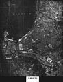
 Plattegrond 1897, stad en omgeving - 20651101 - RCE.jpg 871 × 1,200; 343 KB
-

-
-

-
-

-
-

-

-
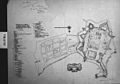
 Plattegrond stad en omgeving, uit 1796 - 20651091 - RCE.jpg 924 × 1,200; 267 KB
-
 Plattegrond uit 17de eeuw - 20651068 - RCE.jpg 1,200 × 884; 370 KB
-
 Plattegrond uit 17de eeuw - 20651069 - RCE.jpg 881 × 1,200; 331 KB
-

-
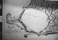
 Plattegrond van Colombo uit 1659 - 20651133 - RCE.jpg 1,200 × 751; 241 KB
-
 Plattegrond van Colombo uit 1697, linkergedeelte - 20651144 - RCE.jpg 1,200 × 941; 397 KB
-
 Plattegrond van Colombo uit 1697, rechtergedeelte - 20651145 - RCE.jpg 1,200 × 943; 388 KB
-
 Plattegrond van Colombo uit 1698 - 20651141 - RCE.jpg 1,200 × 823; 226 KB
-
 Plattegrond van Colombo uit 1698 - 20651146 - RCE.jpg 1,200 × 779; 338 KB
-
 Plattegrond van fort van Colombo, 1864 - 20651139 - RCE.jpg 1,435 × 1,760; 521 KB
-
 Plattegrond van fort van Colombo, circa 1800 - 20651140 - RCE.jpg 881 × 1,200; 395 KB
-
 Plattegrond van fort, 19de eeuw - 20651100 - RCE.jpg 1,090 × 1,200; 496 KB
-
 Plattegrond van haven Colombo, 1794 - 20651137 - RCE.jpg 747 × 1,031; 264 KB
-
 Plattegrond van kasteel in Colombo 1697, naar opname 1692 - 20651142 - RCE.jpg 1,200 × 861; 214 KB
-

-
 St. Peter’s Mission Church, voorzijde - 20651166 - RCE.jpg 1,200 × 796; 239 KB
-
 Stadsplattegrond uit 17de eeuw, negatieve afdruk - 20651070 - RCE.jpg 882 × 1,200; 285 KB
-
 Stadsplattegrond uit 17de eeuw, negatieve afdruk - 20651071 - RCE.jpg 1,200 × 844; 185 KB
-
 Stadsplattegrond uit 17de eeuw, negatieve afdruk - 20651072 - RCE.jpg 1,200 × 891; 224 KB
-
 Stadsplattegrond uit 18de eeuw, gedeelte linksboven - 20651077 - RCE.jpg 1,200 × 902; 316 KB
-
 Stadsplattegrond uit 18de eeuw, gedeelte linksboven - 20651081 - RCE.jpg 1,200 × 914; 343 KB
-
 Stadsplattegrond uit 18de eeuw, gedeelte linksonder - 20651079 - RCE.jpg 1,200 × 876; 355 KB
-
 Stadsplattegrond uit 18de eeuw, gedeelte linksonder - 20651088 - RCE.jpg 1,200 × 901; 344 KB
-
 Stadsplattegrond uit 18de eeuw, gedeelte rechtsboven - 20651078 - RCE.jpg 1,200 × 904; 371 KB
-
 Stadsplattegrond uit 18de eeuw, gedeelte rechtsboven - 20651087 - RCE.jpg 1,200 × 915; 311 KB
-
 Stadsplattegrond uit 18de eeuw, gedeelte rechtsonder - 20651080 - RCE.jpg 1,200 × 896; 359 KB
-
 Stadsplattegrond uit 18de eeuw, gedeelte rechtsonder - 20651089 - RCE.jpg 1,200 × 901; 382 KB
-
 Stadsplattegrond uit de 20ste eeuw - 20651067 - RCE.jpg 925 × 1,200; 377 KB
-
 Stoepa, detail - 20652923 - RCE.jpg 1,193 × 1,200; 557 KB
-
 Stoepa’s - 20652922 - RCE.jpg 1,200 × 1,189; 531 KB
-
 Stoepa’s - 20652924 - RCE.jpg 1,200 × 1,198; 543 KB
-
 Tekeing reconstructie 1901 van 18de eeuwse plattegrond - 20651130 - RCE.jpg 1,200 × 837; 349 KB
-
 Tekening haven van Colombo - 20651132 - RCE.jpg 1,200 × 803; 222 KB
-
 Tekening van Gouvernement, na 18de eeuwse herbouw - 20652227 - RCE.jpg 1,200 × 934; 233 KB
-
 Versterkingsplan fort, 1787, gedeelte linksboven - 20651105 - RCE.jpg 1,200 × 860; 292 KB
-
 Versterkingsplan fort, 1787, gedeelte linksonder - 20651103 - RCE.jpg 1,200 × 830; 281 KB
-
 Versterkingsplan fort, 1787, gedeelte linksonder - 20651107 - RCE.jpg 1,200 × 849; 271 KB
-
 Versterkingsplan fort, 1787, gedeelte rechtsboven - 20651102 - RCE.jpg 1,200 × 864; 267 KB
-
 Versterkingsplan fort, 1787, gedeelte rechtsboven - 20651106 - RCE.jpg 1,200 × 858; 273 KB
-
 Versterkingsplan fort, 1787, gedeelte rechtsonder - 20651104 - RCE.jpg 1,200 × 843; 299 KB
-
 Versterkingsplan fort, 1787, gedeelte rechtsonder - 20651108 - RCE.jpg 1,200 × 824; 296 KB
-
 Vogelvluchtplattegrond - 20651136 - RCE.jpg 1,200 × 861; 185 KB
-
 Voormalig Delftse Poort - 20651164 - RCE.jpg 798 × 1,200; 231 KB
-
 Voormalig Delftse Poort, westzijde - 20651163 - RCE.jpg 1,200 × 797; 202 KB
-
 Voormalig Dutch Hospital, binnenplaats - 20651157 - RCE.jpg 1,200 × 798; 190 KB
-
 Voormalig Dutch Hospital, dakenplan - 20651158 - RCE.jpg 1,200 × 797; 309 KB
-
 Voormalig Dutch Hospital, dakenplan - 20651159 - RCE.jpg 1,200 × 798; 255 KB
-
 Voormalig Dutch Hospital, detail kapvoet - 20651153 - RCE.jpg 799 × 1,200; 274 KB
-
 Voormalig Dutch Hospital, hoek van complex, zuidoostzijde - 20651151 - RCE.jpg 1,200 × 797; 268 KB
-
 Voormalig Dutch Hospital, kapconstructie - 20651154 - RCE.jpg 1,200 × 799; 266 KB
-
 Voormalig Dutch Hospital, langs gevel, zuidoostzijde - 20651152 - RCE.jpg 1,200 × 797; 293 KB
-
 Voormalig Dutch Hospital, westgevel - 20651156 - RCE.jpg 1,200 × 797; 266 KB
-
 Voormalig Dutch Hospital, zuidgevel - 20651160 - RCE.jpg 1,200 × 797; 328 KB
-
 Voormalig Dutch Hospital, zuidzijde - 20651155 - RCE.jpg 1,200 × 797; 329 KB
-
 Voormalig Dutch Hospital, zuidzijde - 20651161 - RCE.jpg 1,200 × 797; 346 KB
-
 Voormalig Dutch Hospital, zuidzijde - 20651162 - RCE.jpg 1,200 × 797; 363 KB
-
 Wolvendaalse Kerk, voorgevel - 20652234 - RCE.jpg 1,200 × 897; 286 KB
-
 Wolvendaelse kerk, geveltop - 20652916 - RCE.jpg 1,200 × 1,198; 397 KB
-
 Wolvendaelse kerk, grafzerken buitenzijde - 20652917 - RCE.jpg 1,200 × 1,199; 463 KB
-
 Wolvendaelse kerk, grafzerken buitenzijde - 20652918 - RCE.jpg 1,200 × 1,197; 413 KB
-
 Wolvendaelse kerk, ingang - 20652919 - RCE.jpg 1,200 × 1,196; 422 KB
-
 Wolvendaelse kerk, preekstoel - 20652921 - RCE.jpg 1,198 × 1,200; 163 KB
-
 Wolvendaelse kerk, straatnaambord - 20652915 - RCE.jpg 1,200 × 1,194; 358 KB
-
 Wolvendaelse kerk, voorgevel - 20652914 - RCE.jpg 1,200 × 1,199; 341 KB
-
 Wolvendaelse kerk, voorgevel, ged. - 20652920 - RCE.jpg 1,200 × 1,190; 423 KB


