Category:Passerelle provisoire sur la Saône à Tournus
Jump to navigation
Jump to search
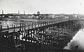
English: This temporary footbridge was built to replace the stone bridge deleted by the germans at the end of WWII.
| Object location | | View all coordinates using: OpenStreetMap |
|---|
Media in category "Passerelle provisoire sur la Saône à Tournus"
The following 3 files are in this category, out of 3 total.
-
 Tournus - Le pont suspendu et la passerelle.jpg 863 × 596; 216 KB
-
 Tournus - passerelle en bois vers 1955 - vue vers l'abbaye.jpg 1,507 × 934; 270 KB
-
 Tournus - passerelle en bois vers 1955 - vue vers la Madeleine.jpg 1,521 × 944; 291 KB


