Category:Open space in Plymouth
Jump to navigation
Jump to search
This is a category containing media of open space in the city of Plymouth, England. This includes parks, walkways, woodland areas and anything else similar.
Media in category "Open space in Plymouth"
The following 20 files are in this category, out of 20 total.
-

-

-
 Concealed Air Raid Shelter - geograph.org.uk - 288338.jpg 640 × 427; 116 KB
-

-
 Devonport - geograph.org.uk - 31420.jpg 640 × 330; 79 KB
-
-
 Jennycliff - geograph.org.uk - 1580413.jpg 640 × 402; 48 KB
-
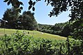
 Open space, Southway - geograph.org.uk - 1587553.jpg 640 × 456; 100 KB
-

-
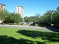 Plymouth , Armada Way - geograph.org.uk - 1160780.jpg 640 × 480; 86 KB
-
 Plymouth , Armada Way and Green - geograph.org.uk - 1445712.jpg 640 × 480; 90 KB
-
 Plymouth looking towards Mutton Cove - geograph.org.uk - 890653.jpg 640 × 480; 65 KB
-
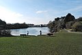 Radford Lake - geograph.org.uk - 1183831.jpg 640 × 429; 54 KB
-

-
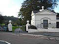 The gatehouse at Radford Park - geograph.org.uk - 1554991.jpg 640 × 480; 80 KB
-
 The Tamar Bridge - geograph.org.uk - 1375286.jpg 640 × 428; 76 KB
-
 The Tamar bridges - geograph.org.uk - 797653.jpg 640 × 624; 126 KB
-
 The West Side of Plymouth Hoe - geograph.org.uk - 306090.jpg 640 × 427; 111 KB
-
 Viewpoint by the Tamar Bridges - geograph.org.uk - 816956.jpg 640 × 427; 105 KB
-
 West Hoe Road - geograph.org.uk - 885160.jpg 640 × 480; 71 KB


