Category:Old maps of the Canadian Arctic region
Jump to navigation
Jump to search
Media in category "Old maps of the Canadian Arctic region"
The following 23 files are in this category, out of 23 total.
-

-
 HOOPER(1853) p459 THE COUNTRY OF THE TUSKI.jpg 3,281 × 2,470; 3.43 MB
-
 HEINZELMANN(1855) 16.1013 Kartenblatt Nordwestpassage.jpg 2,137 × 1,525; 1.74 MB
-
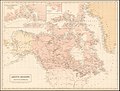 Arctic Regions and British America, Black, 1854.jpg 2,578 × 1,950; 4.68 MB
-
 Bradley Land.jpg 554 × 596; 67 KB
-
 Carte de Groenland (1647) - Isaac La Peyrère - 1 full.png 8,287 × 3,623; 30.42 MB
-
 Davisstraße (1700) 01.jpg 3,501 × 2,069; 5.45 MB
-
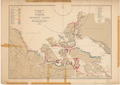
 Discoveries in the Arctic Regions, Ross, 1834.jpg 1,985 × 1,500; 2.5 MB
-

-
 Discoveries in the Arctic Sea up to MDCCCLIV LOC 2018593012.jpg 14,224 × 11,760; 19.03 MB
-
 Discoveries in the Arctic Sea with additions and changes to 1909 11-c.170-1909b.png 24,267 × 19,917; 1.35 GB
-
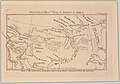 Discoveries of Messrs. Dease and Simpson in 1838-9 (14166789030).jpg 2,500 × 1,745; 1.78 MB
-
 Explorations in Northern Canada and adjacent portions of Greenland and Alaska 1904 11-c.170-1904.png 24,957 × 17,613; 1.23 GB
-
 Franklin 11-c.170-1911-s3168k.png 20,170 × 20,670; 1.17 GB
-
 Franz Boas map.png 372 × 484; 20 KB
-

-

-

-
 Luke Foxe voyage account (North-West Fox, 1635) - 2 foldout map -1 full view.png 5,742 × 4,226; 39.96 MB
-
 Luke Foxe voyage account (North-West Fox, 1635) - 3 foldout map - 2 Hudson Bay.png 1,539 × 1,360; 4.46 MB
-
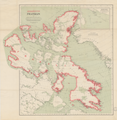
 Map of Canada's Arctic Archipelago, circa 1903.jpg 2,000 × 2,654; 4.63 MB
-

-
 Wellington Channel Melville Island &c from Admiralty Chart 1862.jpg 2,257 × 1,200; 2.24 MB
%27_(11090299473).jpg)
_p459_THE_COUNTRY_OF_THE_TUSKI.jpg)
_16.1013_Kartenblatt_Nordwestpassage.jpg)


_-_Isaac_La_Peyr%C3%A8re_-_1_full.png)
_01.jpg)


.jpg)


_-_3_fig_2_-_map_of_Hudson_Strait_and_Hudson_Bay.png)
_-_4_double_page_with_fig_3_-_Winter_Harbour.png)
_-_5_fig_3_-_Winter_Harbour_at_Churchill_River_-_1_full.png)
_-_2_foldout_map_-1_full_view.png)
_-_3_foldout_map_-_2_Hudson_Bay.png)

_-_2_foldout_map_The_Platt_of_Sayling_-_1_full_view.png)
