Category:Old maps of borders of Colombia
Jump to navigation
Jump to search
Media in category "Old maps of borders of Colombia"
The following 13 files are in this category, out of 13 total.
-
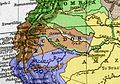 B-C-E-P claims and reivindications.jpg 373 × 261; 53 KB
-
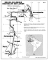
 Brazil-Colombia border 1.png 990 × 1,340; 142 KB
-
 Brazil-Colombia border map 2.png 839 × 1,056; 127 KB
-
 Colombia-Panama border map.jpg 750 × 994; 222 KB
-

-
 Mapa de la región limítrofe entre Brasil y Colombia.jpg 1,694 × 1,415; 690 KB
-
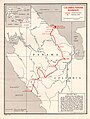
 Mapa de los límites de Colombia en 1905.jpg 2,014 × 2,500; 1.43 MB
-
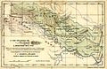
 Mapa de territorios cedidos por Perú a Colombia.jpg 834 × 610; 136 KB
-
 Mapa del laudo arbitral entre Colombia y Venezuela.JPG 977 × 1,306; 258 KB
-
 Mapa del Modus-Vivendi entre Perú y Colombia.jpg 1,831 × 1,197; 536 KB
-
 Mapa del Perú sobre límites con Ecuador.jpg 2,885 × 1,683; 937 KB
-
 Mappa das republicas de Venezuela, Nova Granada e Ecuador - btv1b8441178s.jpg 4,776 × 3,577; 3.06 MB
-


