
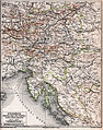
Category:Old maps of Styria
States of Austria:  Burgenland ·
  Carinthia ·
  Lower Austria ·
  Salzburg ·
  Styria ·
  Tyrol ·
  Upper Austria ·
  Vienna ·
  Vorarlberg
Use the appropriate category for maps showing all or a large part of Styria. See subcategories for smaller areas:
| If the map shows | Category to use |
|---|---|
| Styria on a recently created map | Category:Maps of Styria or its subcategories |
| Styria on a map created more than 70 years ago | Category:Old maps of Styria or its subcategories |
| the history of Styria on a recently created map | Category:Maps of the history of Styria or its subcategories |
| the history of Styria on a map created more than 70 years ago | Category:Old maps of the history of Styria or its subcategories |
Deutsch: Karten der Steiermark, die älter als 70 Jahre sind.
English: Maps of Styria older than 70 years
Subcategories
This category has the following 10 subcategories, out of 10 total.
Media in category "Old maps of Styria"
The following 100 files are in this category, out of 100 total.
-

-
 "Stiria = Steymarck" (22232485306).jpg 3,963 × 3,017; 2.78 MB
-
 Austria Lazius 1662 Atlas Blaeuw.jpg 11,220 × 7,918; 85.1 MB
-
 Stiria vulgo Steyrmarck - CBT 5878198.jpg 5,739 × 4,485; 6.06 MB
-

-
 Herzogthum Steyermark.jpg 4,546 × 5,329; 8.03 MB
-
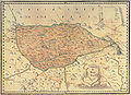
 Steiermark BV039583250.jpg 9,482 × 11,565; 13.05 MB
-
 Stmk Ktn Krain Görz Meyer 3 Auflage ca 1880.jpg 6,019 × 7,649; 62.12 MB
-
 Meyers leiner Hand-atlas 1893 (73136721).jpg 6,530 × 5,263; 9.3 MB
-
 Wien - 34-48.jpg 3,409 × 4,952; 4.56 MB
-
 390 of 'Die Erde. Eine allgemeine Erd- und Länderkunde, etc' (11299932233).jpg 1,498 × 1,421; 706 KB
-
 Admont und Hieflau. NYPL1226589.tiff 5,235 × 4,400; 65.92 MB
-
 Aufnahmeblatt 4955-2 1877 Rax.jpg 9,659 × 7,451; 86.02 MB
-
 Aufnahmeblatt 4955-4 Mürzzuschlag Langenwang-Mürzzuschlag.jpg 3,704 × 3,104; 8.2 MB
-
 Aufnahmeblatt 4955-4 Mürzzuschlag.jpg 9,664 × 7,246; 47.52 MB
-
 Aufnahmeblatt 4956-3 Kirchberg Feistritz Wechsel Mönichkirchen.jpg 10,358 × 7,446; 58.11 MB
-
 Aufnahmeblatt 5056-1 Friedberg Vorau Dechantskirchen Festenburg.jpg 9,645 × 7,400; 51.68 MB
-
 Aufnahmeblatt 5056-2 Schäffern Zöbern Bernstein.jpg 9,620 × 7,373; 49.79 MB
-
 Aufnahmeblatt 5154-3.jpg 9,694 × 7,395; 38.11 MB
-
 Aufnahmeblatt 5154-4.jpg 9,621 × 7,382; 32.54 MB
-
 Aufnahmeblatt 5254-3 1878 farbig Glashütten, Weineben, Wolfsberg bearbeitet.jpg 9,659 × 7,398; 28.93 MB
-
 Aufnahmeblatt 5255-1.jpg 9,619 × 7,400; 29.73 MB
-
 Aufnahmeblatt 5255-3 1879.jpg 9,684 × 7,427; 28.81 MB
-
 Aufnahmeblatt 5354-1.jpg 9,668 × 7,316; 34.83 MB
-
 Aufnahmeblatt 5354-2.jpg 9,738 × 7,396; 38.16 MB
-
 Aufnahmeblatt 5354-4.jpg 9,709 × 7,320; 69.3 MB
-
 Aufnahmeblatt 5355-1.jpg 9,682 × 7,352; 37.01 MB
-
 Aufnahmeblatt 5355-3 1879 Drautal.jpg 9,725 × 7,409; 37.41 MB
-

-

-

-

-
 AvI Brucker Kreis Ausschnitt Lasnitz.jpg 1,540 × 1,073; 1.85 MB
-
 AvI Brucker Kreis.jpg 9,002 × 7,650; 22.78 MB
-
 Brucker Kreis Ausschnitt Lasnitz.jpg 2,501 × 1,736; 3.97 MB
-
 Brucker Kreis.jpg 7,477 × 5,433; 31.98 MB
-
 Charte Steyrmarckt (Merian).jpg 1,648 × 1,230; 647 KB
-
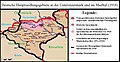 Deutsches Siedlungsgebiet Untersteiermark.jpg 1,146 × 592; 225 KB
-
 Deutschlandsberg Bezirkshandkarte 1910.jpg 6,800 × 9,957; 91.47 MB
-
 Ducatus Stiriae novissima tabula - CBT 5878215.jpg 5,623 × 4,749; 8.66 MB
-
 Duisitzkar Josephinische Landesaufnahme.jpg 2,000 × 1,617; 541 KB
-
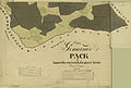 Forsthaus, Pack Schmuckblatt.jpg 9,598 × 6,497; 9.82 MB
-
 Geologische Karte Unterdrauburg 1926.jpg 11,909 × 9,764; 65.31 MB
-
 Giglachseen Josephinische Landesaufnahme.jpg 1,979 × 1,272; 353 KB
-
 Goldschmiedschlössl Franz.Kat.jpg 1,022 × 656; 337 KB
-
 Grabstaetten-Karte der Steiermark.jpg 3,864 × 4,014; 10.43 MB
-
 Graz - 33-47.jpg 3,461 × 4,952; 5.15 MB
-
 Graz und Umgebung.jpg 9,808 × 7,440; 91.22 MB
-
 Graz. NYPL1226660.tiff 4,432 × 5,315; 67.4 MB
-
 Innerösterreich Sanson.jpg 11,811 × 8,659; 67.58 MB
-
 Josephinische Landesaufnahme Mooskirchen Grazer Feld.jpg 8,448 × 5,471; 9.02 MB
-
 Josephinische Landesaufnahme Schwanberg.jpg 8,424 × 5,468; 10.01 MB
-
 Josephinische Landesaufnahme Semmering, Prein steirische Seite.JPEG 8,440 × 5,489; 19.84 MB
-
 Josephinische Landesaufnahme Stainz Wildon.jpg 8,392 × 5,449; 11.71 MB
-
 JosLA Leibnitz.jpg 8,448 × 5,473; 12.13 MB
-
 Judenburg. NYPL1226658.tiff 5,419 × 4,496; 69.75 MB
-
 K.u.K. Zeit Stadtplan Fürstenfeld.jpg 3,368 × 4,308; 2.28 MB
-
 Karte der Steiermark als Brustschild des Doppeladlers.jpg 4,710 × 5,196; 24.33 MB
-
 Kataster Mappenkopie Pack ad II+XVIII+XIX+ad XIX.jpg 8,574 × 5,887; 16.53 MB
-
 Kataster Mappenkopie Pack Uebersicht.jpg 1,715 × 2,621; 1.85 MB
-
 Kataster Mappenkopie Pack XIII+XIV+XV+XVI.jpg 8,596 × 6,312; 12.71 MB
-
 Kataster Mappenkopie Pack XVII.jpg 4,669 × 3,183; 8.25 MB
-
 Klagenfurt - 32-47.jpg 3,444 × 4,984; 3.9 MB
-
 Kronland Steiermark vor 1850.jpg 8,432 × 9,659; 122.54 MB
-
 Landgerichte Burgfriede Steiermark 18 Jhdt.jpg 4,803 × 4,694; 6.19 MB
-
 Laßnitz zwischen Murau und Friesach.jpg 961 × 881; 468 KB
-
 Lieboch Tobelbad 1872.jpg 9,949 × 10,083; 51.64 MB
-
 Linz - 32-48.jpg 3,395 × 4,945; 3.78 MB
-
 Ljubljana (8627978309).jpg 4,000 × 3,000; 2.39 MB
-
 Mahrenberg 1825 Franziszeischer Kataster.jpg 1,950 × 1,628; 425 KB
-
 Meyers b15 s0256a.jpg 800 × 622; 188 KB
-
 Reilly 131.jpg 1,255 × 907; 472 KB
-
 Reilly 132.jpg 1,235 × 1,056; 564 KB
-
 Reilly 133.jpg 1,265 × 912; 437 KB
-
 Reilly 134.jpg 1,330 × 1,096; 553 KB
-
 Reilly 135.jpg 1,296 × 1,008; 614 KB
-
 Schwarzenberg-Karte.jpg 2,237 × 1,573; 1.58 MB
-
 St. Pölten - 33-48.jpg 3,401 × 4,934; 4.88 MB
-
 Steiermark Kaernten Celje Ottens.JPG 3,648 × 2,736; 3.15 MB
-
 Steiermark Karte Meyers Konversations-Lexikon 5 Auflage Stand ca 1899.jpg 14,339 × 11,464; 187.42 MB
-
 Steiermark L.B.Elwe & D.M.Langeveld.JPG 3,648 × 2,736; 2.99 MB
-
 Steiermark Perthes 1855.jpg 6,358 × 5,241; 36.55 MB
-
 Steiermark Seutter 1728 Radkersburg.jpg 1,092 × 902; 1.23 MB
-
 Steiermark Seutter 1728.jpg 6,467 × 5,342; 39.02 MB
-
 Steiermark und Kärnten Danckert 1620.jpg 6,129 × 5,707; 31.8 MB
-
 Steiermark Vischer 1678 Ausschnitt Lasnitz.jpg 1,226 × 853; 1.37 MB
-
 Steiermark Vischer 1678.jpg 8,916 × 7,835; 55.17 MB
-
 Steyermarck in Vier Eisen Viertl 1782.jpg 7,404 × 4,761; 29.26 MB
-
 Stiriae C.Weigelü Steiermark Styria.JPG 3,648 × 2,736; 2.61 MB
-
 Styria 1630 Mercantor Celje 2015.JPG 2,736 × 3,648; 3.7 MB
-
 Styria 1630 Mercantor.JPG 3,648 × 2,736; 2.79 MB
-
 Szombathely - 34-47.jpg 3,443 × 4,945; 4.73 MB
-
 Topographia Austriacarum (Merian) 017.jpg 2,000 × 1,661; 664 KB
-
 Topographia Austriacarum (Merian) 193.jpg 2,000 × 1,609; 616 KB
-
 Vischers Kriegskarte der Steiermark.jpg 3,543 × 3,170; 7.12 MB
-
 Von Styria ca 1600 Celje 2015.JPG 2,736 × 3,648; 3.29 MB
-
 Von Styria Pieter van den Keere.JPG 3,648 × 2,736; 2.67 MB
-
 Wildon und Leibnitz 5255.jpg 6,713 × 4,977; 16.71 MB
-
 Zgodovinsky Archiv Celje 2015.JPG 2,736 × 3,648; 1.93 MB
-
 Zgodovinsky Arhiv Celje 2015.JPG 3,648 × 2,736; 2.73 MB
.jpg)
.jpg)


.jpg)


.jpg)

.jpg)


_(14592598817).jpg)
_(14592620337).jpg)
_(14756125086).jpg)
_(14798991583).jpg)


.jpg)


.jpg)


_017.jpg)
_193.jpg)


