Category:Old maps of Halle (Saale)
Jump to navigation
Jump to search
Subcategories
This category has only the following subcategory.
Media in category "Old maps of Halle (Saale)"
The following 18 files are in this category, out of 18 total.
-
 "Saxonia superior & Hall Episcopatus" (22268899321).jpg 3,812 × 3,116; 2.41 MB
-

-
 HERTZBG(1) p559 Plan der Umgegend von Halle an der Saale im Mittelalter.jpg 3,129 × 3,693; 5.02 MB
-
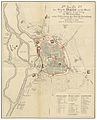 HERTZBG(1) p561 Plan der Stadt Halle an der Saale im Mittelalter.jpg 3,081 × 3,809; 6.08 MB
-
 HERTZBG(3) p685 Plan von Halle an der Saale.jpg 2,707 × 4,007; 5.74 MB
-
 436 of 'Neumanns Orts-Lexikon des Deutschen Reichs' (11228088974).jpg 2,720 × 1,756; 1.46 MB
-
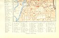 437 of 'Neumanns Orts-Lexikon des Deutschen Reichs' (11225795766).jpg 2,720 × 1,756; 1.18 MB
-

-

-

-

-
 Geognostische Karte der Umgegend von Halle - btv1b8440930d.jpg 5,220 × 4,403; 4.51 MB
-
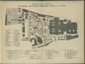 Gewerbeausstellung 1881.png 3,484 × 2,633; 10.96 MB
-
 Meyers b8 s0022a.jpg 1,535 × 2,048; 705 KB
-

-
 Plan der stadt halle und umgebung 1814.jpg 1,025 × 1,286; 243 KB
-

-

.jpg)
.jpg)
_p559_Plan_der_Umgegend_von_Halle_an_der_Saale_im_Mittelalter.jpg)
_p561_Plan_der_Stadt_Halle_an_der_Saale_im_Mittelalter.jpg)
_p685_Plan_von_Halle_an_der_Saale.jpg)
.jpg)
.jpg)
.jpg)
.jpg)


_-_herausgegeben_vom..._R._Loest_-_btv1b530209615.jpg)

_(14579359529).jpg)
