Category:Old maps of Gansu
Jump to navigation
Jump to search
Subcategories
This category has the following 2 subcategories, out of 2 total.
Media in category "Old maps of Gansu"
The following 62 files are in this category, out of 62 total.
-
 Da Ming yu di tu LOC 2002626776-9.jpg 9,889 × 8,990; 11.94 MB
-
 Da Ming yu di tu LOC 2002626776-9.tif 9,889 × 8,990; 254.35 MB
-
 Guang yu tu - er juan LOC 2008623187-14.jpg 4,340 × 4,658; 4.13 MB
-
 Guang yu tu - er juan LOC 2008623187-14.tif 4,340 × 4,658; 57.84 MB
-
 Guang yu tu - er juan LOC 2008623187-16.jpg 4,340 × 4,658; 4.12 MB
-
 Guang yu tu - er juan LOC 2008623187-16.tif 4,340 × 4,658; 57.84 MB
-
 Guang yu tu - er juan LOC 2008623187-19.jpg 4,340 × 4,658; 4.39 MB
-
 Guang yu tu - er juan LOC 2008623187-19.tif 4,340 × 4,658; 57.84 MB
-
 Guang yu tu - er juan LOC 2008623187-20.jpg 4,340 × 4,658; 4.1 MB
-
 Guang yu tu - er juan LOC 2008623187-20.tif 4,340 × 4,658; 57.84 MB
-
 Guang yu tu - er juan LOC 2008623187-24.jpg 4,320 × 4,658; 4.42 MB
-
 Guang yu tu - er juan LOC 2008623187-24.tif 4,320 × 4,658; 57.57 MB
-
 Guang yu tu - er juan LOC 2008623187-34.jpg 4,360 × 4,658; 4.32 MB
-
 Guang yu tu - er juan LOC 2008623187-34.tif 4,360 × 4,658; 58.1 MB
-
 Guang Yutu 1558 Vol 1 Pg 20 Shaanxi 2.jpg 4,360 × 4,658; 3.81 MB
-
 Guang Yutu 1558 Vol 1 Pg 19 Shaanxi 1.jpg 4,360 × 4,658; 4.02 MB
-

-
 "Xensi, Imperii Sinarum provincia Tertia. " (22240618482).jpg 3,656 × 3,036; 2.45 MB
-
 Xensi… - Atlas Maior, vol 11, map 15 - Joan Blaeu, 1667 - BL 114.h(star).11.(15).jpg 4,000 × 3,428; 2.17 MB
-
 Atlas Van der Hagen-KW1049B13 038-XENSI. IMPERII SINARVM PROVINCIA TERTIA.jpeg 5,500 × 4,608; 3.66 MB
-

-
-

-

-
 Der Jesuiten-Atlas der Kanghsi-Zeit - China und die Aussenlaender LOC 74650033-24.jpg 9,617 × 8,449; 10.06 MB
-
 Der Jesuiten-Atlas der Kanghsi-Zeit - China und die Aussenlaender LOC 74650033-24.tif 9,617 × 8,449; 232.47 MB
-
 Chen-Si - par Jean-Baptiste d'Anville - btv1b530092521.jpg 6,467 × 5,585; 6.42 MB
-

-
 Province de Chen-si - (tirée du P. Duhalde) - btv1b59630556.jpg 6,760 × 5,776; 6.19 MB
-
-
 Anville Nouvel atlas de la Chine - Page40 chen si.jpg 4,640 × 4,056; 7.16 MB
-
 Anville Nouvel atlas de la Chine - Page95 - thibet 4e feuille ho ho nor.jpg 4,214 × 2,568; 3.79 MB
-
-
 Province de Chen-si - (par J.-B. d'Anville) - btv1b8468518m.jpg 10,642 × 8,257; 14.75 MB
-

-
 Da Qing fen sheng yu tu LOC 2002626726-8.jpg 5,303 × 4,527; 2.43 MB
-
 Da Qing fen sheng yu tu LOC 2002626726-8.tif 5,303 × 4,527; 68.68 MB
-
 Province de Chen-si no. 16 (NYPL b13654478-5053010).tiff 9,756 × 7,699, 2 pages; 215.17 MB
-
 Province de Chen-si no. 16 (NYPL b13654478-5053011).tiff 10,328 × 7,374, 2 pages; 218.16 MB
-

-
-
 Zhi li ge sheng yu di quan tu - Zhang Zongjing - btv1b53103898v (48 of 69).jpg 5,083 × 4,423; 2.85 MB
-
 Gansu quan tu LOC gm71005112.jpg 10,880 × 10,112; 12.26 MB
-
 Gansu quan tu LOC gm71005112.tif 10,880 × 10,112; 314.77 MB
-
 Huang chao zhi sheng di yu quan tu - btv1b531099218 (19 of 38).jpg 6,236 × 4,543; 3.07 MB
-
 Tian xia zong yu tu. LOC 2002626780-7.jpg 3,778 × 3,117; 889 KB
-
 Tian xia zong yu tu. LOC 2002626780-7.tif 3,778 × 3,117; 33.69 MB
-
 310 of 'China in Transformation ... With ... maps and diagrams' (11291250283).jpg 1,287 × 1,142; 415 KB
-
 1912 China map from National Geographic.jpg 6,980 × 5,326; 10.65 MB
-
 Map of Tibet in 1917, from- STANFORD(1917) p41-42 PLATE12. KANSU (14780689431) (cropped).jpg 2,633 × 3,139; 2.84 MB
-
 STANFORD(1917) p41-42 PLATE12. KANSU (14780689431).jpg 4,923 × 4,507; 7.5 MB
-

-

-
 Du Halde - Description de la Chine - Villes de second ordre de la province de Chensi.jpg 2,488 × 2,920; 1.44 MB
-
 EB9 China.png 2,754 × 3,531; 14.21 MB
-
 Map of Tibet (Thibet) in 1878, from- EB9 China (cropped).png 913 × 1,868; 2.13 MB
-
 Missions catholiques au Kansu.png 1,560 × 2,130; 9.38 MB
-
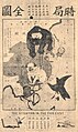 Political Map of 19th Century China(時局全圖).jpg 580 × 974; 259 KB
-
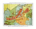 Territories of relief during the famine in China around 1880.jpg 1,740 × 1,404; 416 KB
-
 Txu-oclc-6654394-nk-47-1st-ed.jpg 4,740 × 5,170; 7.97 MB
-
 БСЭ1. Гань-су.jpg 542 × 472; 149 KB
-
 亚新地学社1936年《袖珍中华全图》--24甘肃省.jpg 2,150 × 1,541; 794 KB


_;_excudebat_Ioannes_Blaeu_-_btv1b5963053c.jpg)
.jpg)
.11.(15).jpg)

.jpg)
.jpg)
.jpg)
.jpg)


_-_Grav%C3%A9_par_Delahaye_-_btv1b8492944f.jpg)
_-_btv1b59630556.jpg)
_;_grav%C3%A9_par_Delahaye_;_Gu%C3%A9lard_sc._-_btv1b5963054s.jpg)


.jpg)
_-_btv1b8468518m.jpg)
.jpg)


.jpg)

.jpg)


_p41-42_PLATE12._KANSU_(14780689431)_(cropped).jpg)
_p41-42_PLATE12._KANSU_(14780689431).jpg)
.jpg)
.jpg)


_in_1878,_from-_EB9_China_(cropped).png)


.jpg)