Category:Old maps of Brest harbours
Jump to navigation
Jump to search
Media in category "Old maps of Brest harbours"
The following 10 files are in this category, out of 10 total.
-
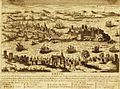
 4Fi00011 Antoine Aveline ca 1700 vue cavalière de la ville de Brest.jpg 6,790 × 4,563; 21.09 MB
-
 4Fi00011 Brest - vue cavalière de la ville depuis la rade au XVIIe siècle.jpg 7,808 × 6,032; 7.18 MB
-
 5Fi614 plan de brest lutte contre les incendies.jpg 4,694 × 3,658; 1.68 MB
-
 Brest ville de bretagne avec un excellent port.jpg 582 × 430; 71 KB
-
 FRAD029 2O 00267 01 01 Plan général du port de Brest et de ses abords.jpg 6,000 × 2,806; 843 KB
-
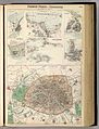 Fullarton, French Ports & Harbours, and Plan of Paris, 1872 - David Rumsey.jpg 6,086 × 7,985; 10.53 MB
-
 Plan et vue du port ville et chateau de Brest ca 1700.jpg 5,752 × 7,822; 34.75 MB
-

-

-
 VuecavalièredeBrest.jpg 734 × 505; 201 KB


._Plan_g%C3%A9n%C3%A9ral_du_port_et_de_ses_abords._Ville_de_Brest_-_btv1b8443979k.jpg)
