Category:October 2009 in the Scottish Borders
Jump to navigation
Jump to search
Council areas (municipalities) of Scotland: Aberdeenshire · Angus · Argyll and Bute · East Lothian · Edinburgh · Falkirk · Fife · Glasgow · Highland · Moray · North Ayrshire · North Lanarkshire · Perth and Kinross · Scottish Borders · Stirling ·
Deutsch: Bilder, die im Oktober 2009 in the Scottish Borders aufgenommen worden sind. Bitte beachten Sie, dass dies weder das Datum des Uploads noch das Datum des Scannens eines Fotos ist.
English: Images/pictures taken in the Scottish Borders during October 2009. Note this is not the date of the upload, nor the date a photo was scanned.
Español: Fotografías o imágenes tomadas en the Scottish Borders durante octubre 2009. No es la fecha de subida ni escaneo, sino la fecha en que las fotografías o imágenes se crearon.
Esperanto: Bildoj faritaj en the Scottish Borders en oktobro 2009. Tio ne estas la dato, kiam la bildoj estis alŝutitaj aŭ skanitaj.
Français : Photographies ou images prises en the Scottish Borders durant octobre 2009. Ce n'est pas la date du téléchargement ou du scan.
Galego: Fotografías ou imaxes tomadas en the Scottish Borders durante outubro 2009. Non é a data de subida nin escaneamento, senón a data na que se crearon as fotografías ou imaxes.
Italiano: Fotografie o immagini scattate a the Scottish Borders nel ottobre 2009. Nota bene: la data non si riferisce né a quella di upload né a quella in cui la foto è stata digitalizzata.
Norsk bokmål: Bilder tatt i the Scottish Borders i løpet av oktober 2009. Merk at dette ikke er datoen for opplasting, eller når et bilde har blitt skannet.
Norsk nynorsk: Bilete teke i the Scottish Borders i løpet av oktober 2009. Merk at dette ikkje er datoen for opplasting, eller når eit bilete har vorte skanna.
Русский: Изображения, сделанные в the Scottish Borders в течение октябрь 2009 (не дата загрузки изображения).
Українська: Зображення, зроблені в the Scottish Borders протягом жовтень 2009. Зауважте, що це не дата завантаження чи дата сканування фотографії.
| October 2008 | ← | October 2009 | → | October 2010 | |||||||
| Jan | Feb | Mar | Apr | May | Jun | Jul | Aug | Sep | Oct | Nov | Dec |
| 18 | 12 | 0 | 28 | 31 | 34 | 57 | 26 | 18 | 49 | 0 | 24 |
|---|---|---|---|---|---|---|---|---|---|---|---|
Media in category "October 2009 in the Scottish Borders"
The following 49 files are in this category, out of 49 total.
-

-
 A grazing field at Darnick - geograph.org.uk - 1548705.jpg 640 × 395; 183 KB
-
 A plaque on Hunter Bridge at Kelso - geograph.org.uk - 1542494.jpg 423 × 640; 139 KB
-
 A sunbathing cat at St Abbs - geograph.org.uk - 1527439.jpg 640 × 412; 144 KB
-
 Above Hownam Burn - geograph.org.uk - 1550273.jpg 640 × 477; 105 KB
-
 Boar, Broughton Place - geograph.org.uk - 1564445.jpg 640 × 480; 143 KB
-
 Burnfoot Cottage - geograph.org.uk - 1547154.jpg 640 × 480; 118 KB
-
-
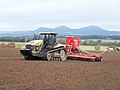
 Claas And Cambridge Rollers - geograph.org.uk - 1548253.jpg 640 × 480; 78 KB
-
-
 Crosscleuch Farm - geograph.org.uk - 1542745.jpg 640 × 480; 130 KB
-
 Dyke on Hownam Law - geograph.org.uk - 1546859.jpg 640 × 470; 92 KB
-
 End of the tarmac - geograph.org.uk - 1547113.jpg 640 × 480; 81 KB
-
 Farmland near Hownam - geograph.org.uk - 1546759.jpg 640 × 480; 75 KB
-
 Farmland near Hownam - geograph.org.uk - 1546889.jpg 640 × 480; 94 KB
-
 Gate, Broughton Place - geograph.org.uk - 1563357.jpg 480 × 640; 153 KB
-
 Heatherhope Burn at Hownam - geograph.org.uk - 1546703.jpg 640 × 479; 120 KB
-
 Kelso Public Library Door 2009.jpg 2,448 × 3,264; 2.14 MB
-
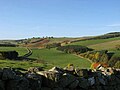
 Lammermuir farmland - geograph.org.uk - 1565957.jpg 640 × 368; 185 KB
-
 Loch of the Lowes reflection - geograph.org.uk - 1528047.jpg 640 × 428; 56 KB
-
 Machinery At Rest - geograph.org.uk - 1547286.jpg 640 × 480; 90 KB
-
 No Crem - geograph.org.uk - 1542550.jpg 640 × 421; 147 KB
-
 Old road above Crosscleuch - geograph.org.uk - 1542738.jpg 640 × 480; 110 KB
-
 Old road sign above Crosscleuch Burn - geograph.org.uk - 1542737.jpg 480 × 640; 91 KB
-
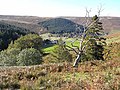
 Path through the bracken - geograph.org.uk - 1546833.jpg 640 × 480; 106 KB
-
 Penvalla - geograph.org.uk - 1562640.jpg 640 × 359; 97 KB
-
 Penvalla - geograph.org.uk - 1562967.jpg 640 × 480; 88 KB
-
 Penvalla and wood - geograph.org.uk - 1563409.jpg 640 × 480; 88 KB
-

-
 Ploughing Near Muirhouselaw - geograph.org.uk - 1542510.jpg 640 × 480; 85 KB
-
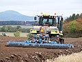
 Ready To Plough Another Five Furrows - geograph.org.uk - 1542527.jpg 640 × 480; 97 KB
-
 Rough grazing beneath Hownam Rings - geograph.org.uk - 1548719.jpg 640 × 480; 75 KB
-
 Rough grazing on Hownam Law - geograph.org.uk - 1548754.jpg 640 × 480; 94 KB
-
 Sheep in the Crosscleuch valley - geograph.org.uk - 1542739.jpg 640 × 480; 133 KB
-
 Sheepfold by the South Grain - geograph.org.uk - 1529093.jpg 640 × 480; 129 KB
-

-
 Sheepfold on Longmoor End - geograph.org.uk - 1542754.jpg 640 × 480; 74 KB
-
 Sign for the Neidpath Inn - geograph.org.uk - 1558543.jpg 480 × 640; 99 KB
-
 Stobo Hope - geograph.org.uk - 1562945.jpg 640 × 480; 108 KB
-
 Stobo Hope - geograph.org.uk - 1562960.jpg 640 × 480; 119 KB
-
 Stobo Hope - geograph.org.uk - 1563930.jpg 640 × 359; 74 KB
-
 Stobo Hopehead - geograph.org.uk - 1563938.jpg 640 × 480; 99 KB
-
 Stone lion, Broughton Place - geograph.org.uk - 1563345.jpg 480 × 640; 162 KB
-
 Surprise parking manoeuvre^ - geograph.org.uk - 1519253.jpg 640 × 480; 96 KB
-
 The Neidpath Inn, Old Town, Peebles - geograph.org.uk - 1558572.jpg 640 × 480; 109 KB
-
 The Street at Hownam - geograph.org.uk - 1548728.jpg 640 × 478; 103 KB
-
 Willow For Biomass - geograph.org.uk - 1536930.jpg 640 × 480; 60 KB
-
 Woodland, Broughton Place - geograph.org.uk - 1564450.jpg 480 × 640; 171 KB
-
 Young woodland, Broughton Place - geograph.org.uk - 1563352.jpg 640 × 480; 135 KB


