Category:Nivajoki–Alajalve Museum Road
Jump to navigation
Jump to search
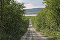
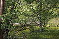
English: Nivajoki–Alajalve road (Alakönkääntie), Nuorgam, Utsjoki, Finland, is a museum road, about 4,8 kilometers long. It was originally only a narrow trail. It was formed as river boats were towed (by manpover) in order to go round the Alaköngäs Rapids of the Tana River. Alaköngäs was inpassable by boat. The Tana boat route and it's bypasses were known to exist in the late 1500's.
Suomi: Nivajoki–Alajalve-tie (Alakönkääntie), Nuorgam, Utsjoki, Suomi, on museotie. Tie on alun perin ollut Tenon Alakönkään kiertamiseksi muodostunut veneenvetotie, enismmäiset maininnat Tenosta kulkureittinä ja sen koskenkiertoteistä ovat 1500-luvun lopulta. Museotie on 4,8 km pitkä.
| Object location | | View all coordinates using: OpenStreetMap |
|---|
road in Utsjoki, Finland  | |||||
| Upload media | |||||
| Instance of | |||||
|---|---|---|---|---|---|
| Location | Utsjoki, Lapland, Regional State Administrative Agency for Lapland, Finland | ||||
| Heritage designation |
| ||||
| Inception |
| ||||
| Length |
| ||||
| Terminus | |||||
 | |||||
Location coordinates point the beginning of the one-way road.
Media in category "Nivajoki–Alajalve Museum Road"
The following 11 files are in this category, out of 11 total.
-
 Alakönkääntie 1.JPG 5,184 × 3,456; 10.3 MB
-
 Alakönkääntie 2.JPG 5,184 × 3,456; 7.66 MB
-
 Alakönkääntie 3.JPG 5,184 × 3,456; 8.37 MB
-
 Alakönkääntie 4.JPG 5,184 × 3,456; 11.46 MB
-
 Alakönkääntie 5.JPG 5,184 × 3,456; 7.67 MB
-
 Alakönkääntie 6.JPG 5,184 × 3,456; 12.02 MB
-
 Alakönkääntie 7.JPG 2,764 × 2,764; 1.75 MB
-
 Alakönkääntie 8.JPG 2,304 × 3,456; 1.41 MB
-
 Nivajoki Alajalve1.jpg 3,769 × 2,827; 1.75 MB
-
 Nivajoki Alajalve2.jpg 4,032 × 3,024; 4.15 MB
-
 Nuorgam Wikivoyage Banner.JPG 5,184 × 748; 2.56 MB


