Category:Ninemile Canyon (Utah)
Jump to navigation
Jump to search
canyon in Duchesne, Carbon, and Uintah counties in Utah, United States, and an archaeological site and a Back Country Byway | |||||
| Upload media | |||||
| Instance of | |||||
|---|---|---|---|---|---|
| Location |
| ||||
| Located in or next to body of water | |||||
| Elevation above sea level |
| ||||
 | |||||
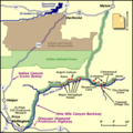
English: Media related to Ninemile Canyon (Utah) (also Nine Mile Canyon), a canyon in the Uintah Basin in Duchesne, Carbon, and Unitah counties in Utah, United States, that is also an archaeological site and Back Country Byway. The canyon is on the northern edge of the West Tavaputs Plateau and the Minnie Maud Ridge on the west, the southern edge of Argyle Ridge in the central part, and the Bad Lands Cliffs on the east.
Subcategories
This category has the following 4 subcategories, out of 4 total.
Media in category "Ninemile Canyon (Utah)"
The following 20 files are in this category, out of 20 total.
-
Abandoned buildings at Nine Mile Canyon.jpg 5,184 × 2,916; 3.68 MB
-
Argyle Canyon turnoff sign.jpg 2,816 × 2,112; 2.81 MB
-
Cottonwood Village Nine Mile Canyon Utah.jpeg 4,288 × 3,216; 7.35 MB
-
Daddycanyon1.jpeg 1,782 × 1,213; 423 KB
-
Daddycanyon2.jpeg 1,772 × 1,213; 561 KB
-
Formations Along Nine Mile Creek - Utah.jpg 3,600 × 2,400; 4.03 MB
-
Formations Along Nine Mile Creek 2 - Utah.jpg 3,600 × 2,400; 4.55 MB
-
My Public Lands Roadtrip- Nine Mile Canyon in Utah (19543419724).jpg 1,256 × 852; 265 KB
-
My Public Lands Roadtrip- Nine Mile Canyon in Utah (19978048790).jpg 4,496 × 3,000; 8.22 MB
-
My Public Lands Roadtrip- Nine Mile Canyon in Utah (19979418909).jpg 3,000 × 4,496; 7.17 MB
-
My Public Lands Roadtrip- Nine Mile Canyon in Utah (20166078055).jpg 4,496 × 3,000; 7.2 MB
-
My Public Lands Roadtrip- Nine Mile Canyon in Utah (20166083975).jpg 4,496 × 3,000; 8.33 MB
-
Nine Mile Canyon Compressor Station.jpeg 2,560 × 1,920; 1.13 MB
-
Nine Mile Canyon dust.jpeg 2,560 × 1,920; 1.13 MB
-
Nine Mile Creek at North Franks Canyon, Utah.jpg 1,512 × 2,688; 1,012 KB
-
NineMileCanyon map.png 400 × 400; 28 KB
-
Rasmussencave.jpeg 1,764 × 1,213; 399 KB
-
Redman Village Nine Mile Canyon.jpeg 3,008 × 2,000; 1.51 MB
Categories:
- Canyons in Utah
- Archaeological sites in Carbon County, Utah
- Archaeological sites in Duchesne County, Utah
- Landforms of Carbon County, Utah
- Landforms of Duchesne County, Utah
- Nine Mile Canyon Back Country Byway
- Landforms of the Uinta Basin
- West Tavaputs Plateau
- Minnie Maud Ridge
- Argyle Ridge
- Bad Land Cliffs
- Locations along Utah State Route 53 (1916-1969)


