Category:Nicholforest
Jump to navigation
Jump to search

civil parish in Cumbria, England, UK  | |||||
| Upload media | |||||
| Instance of | |||||
|---|---|---|---|---|---|
| Location | Carlisle, Cumbria, North West England, England | ||||
| Population |
| ||||
 | |||||
Subcategories
This category has the following 5 subcategories, out of 5 total.
Media in category "Nicholforest"
The following 93 files are in this category, out of 93 total.
-
 A message from above^ - geograph.org.uk - 5004374.jpg 900 × 1,200; 1.13 MB
-
 A view from England to Scotland - geograph.org.uk - 1859200.jpg 640 × 480; 336 KB
-
 Apse, church of St. Nicholas - geograph.org.uk - 4912599.jpg 1,024 × 768; 242 KB
-
 Beech lined road - geograph.org.uk - 910716.jpg 640 × 480; 108 KB
-
 Black Burn - geograph.org.uk - 4912563.jpg 1,024 × 768; 344 KB
-
 Black Rigg - geograph.org.uk - 2690435.jpg 3,888 × 2,592; 1.96 MB
-
 Black Rigg - geograph.org.uk - 2698608.jpg 3,888 × 2,151; 1.16 MB
-
 Black Rigg - geograph.org.uk - 2698609.jpg 3,888 × 2,592; 2.17 MB
-
 Black Rigg pillar in a fire break - geograph.org.uk - 4429200.jpg 640 × 480; 132 KB
-
 Blacksmith's Cottage - geograph.org.uk - 2698599.jpg 3,741 × 2,125; 1.23 MB
-
 Blind Sike - geograph.org.uk - 2690474.jpg 2,824 × 2,308; 1.01 MB
-
 Brownknowe - geograph.org.uk - 2698166.jpg 3,263 × 2,527; 1.37 MB
-
 Bus shelter near Penton - geograph.org.uk - 910675.jpg 640 × 480; 114 KB
-
 Bushfield - geograph.org.uk - 910724.jpg 640 × 480; 60 KB
-
 Catlowdy - geograph.org.uk - 2387224.jpg 640 × 480; 74 KB
-
 Chamot Hill forest - geograph.org.uk - 5802616.jpg 2,048 × 1,536; 1.38 MB
-
 Church of St. Nicholas, Nicholforest - geograph.org.uk - 4890354.jpg 1,024 × 768; 315 KB
-
 Daffodils at Warwicksland - geograph.org.uk - 1859141.jpg 640 × 480; 378 KB
-
 Damp farmland, Kingfield - geograph.org.uk - 910701.jpg 640 × 480; 66 KB
-
 Deerproof enclosure - geograph.org.uk - 2386752.jpg 640 × 480; 89 KB
-
 Draughtsike - geograph.org.uk - 6150221.jpg 640 × 480; 281 KB
-

-
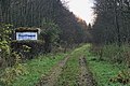
 Embankment of the former Waverley line - geograph.org.uk - 4914456.jpg 1,024 × 768; 182 KB
-

-
 Felled area near Liddel Lodge - geograph.org.uk - 910712.jpg 640 × 359; 67 KB
-
 Field and hedgerow at Catlowdy - geograph.org.uk - 2386753.jpg 640 × 480; 107 KB
-
 Field by Yearning Sike - geograph.org.uk - 2386740.jpg 640 × 480; 96 KB
-
 Field near Hilltop Farm - geograph.org.uk - 2386730.jpg 640 × 480; 108 KB
-
 Footpath by Kershope Burn - geograph.org.uk - 3162580.jpg 800 × 600; 228 KB
-
 Forest near Liddel Tower - geograph.org.uk - 910755.jpg 640 × 359; 55 KB
-
 Forest on Green Rigg - geograph.org.uk - 910750.jpg 640 × 480; 72 KB
-
 Forest path near Kershopefoot - geograph.org.uk - 5802606.jpg 2,048 × 1,536; 1.68 MB
-
 Forest path, Kers Hope - geograph.org.uk - 6564599.jpg 1,600 × 1,200; 837 KB
-
 Gate near the road to Kershopefoot - geograph.org.uk - 5341811.jpg 1,024 × 678; 321 KB
-
 Gates and postbox - geograph.org.uk - 1859178.jpg 640 × 480; 370 KB
-
 Haithwaite - geograph.org.uk - 2698165.jpg 3,420 × 1,564; 948 KB
-
 Haithwaite Moss - geograph.org.uk - 4892200.jpg 1,024 × 768; 205 KB
-
 Hillcrest - geograph.org.uk - 2698154.jpg 3,426 × 1,848; 918 KB
-
 Hilltop Farm - geograph.org.uk - 2386731.jpg 640 × 480; 90 KB
-
 Hunter's Knowe - geograph.org.uk - 2690470.jpg 3,369 × 2,459; 1.7 MB
-
 Kershope Burn - geograph.org.uk - 2690292.jpg 3,803 × 2,465; 1.71 MB
-
 Kershope Forest - geograph.org.uk - 910780.jpg 640 × 359; 54 KB
-
 Kershopefoot - geograph.org.uk - 2690319.jpg 3,888 × 2,592; 1.84 MB
-
 Kershopefoot - geograph.org.uk - 2698134.jpg 3,582 × 2,592; 1.42 MB
-
 Kershopefoot - geograph.org.uk - 5342549.jpg 1,024 × 678; 259 KB
-

-
 Liddel Lodge - geograph.org.uk - 2698600.jpg 3,656 × 2,592; 1.86 MB
-
 Liddel Water - geograph.org.uk - 2698079.jpg 3,888 × 2,592; 1.84 MB
-
 Liddel Water - geograph.org.uk - 4912621.jpg 1,024 × 750; 197 KB
-
 Liddel Water at Penton Bridge - geograph.org.uk - 4889899.jpg 1,024 × 768; 150 KB
-
 Line of old field boundary - geograph.org.uk - 910770.jpg 640 × 359; 63 KB
-
 Lodge and gates - geograph.org.uk - 1859167.jpg 640 × 476; 357 KB
-
 Milestone on the Longtown to Penton road - geograph.org.uk - 1859127.jpg 640 × 477; 349 KB
-
 Nicholforest Hall - geograph.org.uk - 910682.jpg 640 × 480; 83 KB
-
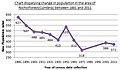 Nicholforest(cumbria) population 1881-2011.jpg 459 × 268; 44 KB
-
 Nookgate - geograph.org.uk - 2698160.jpg 3,849 × 2,535; 1.33 MB
-
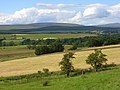
 North Cumbria landscape - geograph.org.uk - 6150240.jpg 640 × 480; 253 KB
-
 Old signpost near Kershopefoot - geograph.org.uk - 5341819.jpg 1,024 × 678; 312 KB
-
 Pasture, Nicholforest - geograph.org.uk - 900926.jpg 640 × 480; 103 KB
-
 Pasture, Nicholforest - geograph.org.uk - 900935.jpg 640 × 480; 123 KB
-
 Pastures above Liddesdale - geograph.org.uk - 900975.jpg 640 × 480; 103 KB
-
 Path along disused railway, Kershopefoot - geograph.org.uk - 5342057.jpg 1,024 × 678; 287 KB
-
 Peacock butterfly, Kers Hope - geograph.org.uk - 6564733.jpg 1,600 × 1,200; 587 KB
-
 Penton Bridge - geograph.org.uk - 3313868.jpg 1,024 × 690; 287 KB
-
 Penton Bridge - geograph.org.uk - 3981400.jpg 640 × 480; 94 KB
-
 Penton Bridge - geograph.org.uk - 4911869.jpg 1,024 × 768; 306 KB
-
 Piperdeanrigg Farm and Chapel Hill - geograph.org.uk - 2387595.jpg 640 × 480; 62 KB
-
 Public bridleway to The Nook - geograph.org.uk - 1859190.jpg 640 × 480; 342 KB
-
 Public footpath to Watleyhurst - geograph.org.uk - 1859164.jpg 640 × 480; 365 KB
-
 Railway Cottages - geograph.org.uk - 2690463.jpg 3,698 × 2,445; 1.05 MB
-
 Replanted area, Brown Knowe - geograph.org.uk - 909443.jpg 640 × 359; 61 KB
-
 Riggcroft - geograph.org.uk - 2386734.jpg 640 × 480; 114 KB
-
 Road near Penton - geograph.org.uk - 3324703.jpg 685 × 1,024; 336 KB
-
 Ryeleahead - geograph.org.uk - 2698294.jpg 3,584 × 2,592; 1.28 MB
-
 Shankend - geograph.org.uk - 2698158.jpg 3,819 × 2,489; 1.44 MB
-
 Sheep at Nicholforest - geograph.org.uk - 4912529.jpg 1,024 × 768; 281 KB
-
 Springs Knowe - geograph.org.uk - 2698291.jpg 3,888 × 2,592; 1.7 MB
-
 Sunny Side - geograph.org.uk - 2698162.jpg 3,888 × 2,592; 1.49 MB
-
 The B6318 in Catlowdy - geograph.org.uk - 5564306.jpg 2,592 × 1,944; 1.48 MB
-
 The Bridge Inn, Penton - geograph.org.uk - 2386735.jpg 640 × 480; 66 KB
-
 The Green Farm - geograph.org.uk - 6150236.jpg 640 × 480; 299 KB
-
 The Huntsman's Inn - geograph.org.uk - 910745.jpg 640 × 480; 97 KB
-
 Valley of the Rae Burn - geograph.org.uk - 2387227.jpg 640 × 480; 102 KB
-
 View over Liddesdale - geograph.org.uk - 900978.jpg 640 × 480; 130 KB
-
 View over Liddesdale - geograph.org.uk - 910706.jpg 640 × 480; 84 KB
-
 View towards Birney Wood - geograph.org.uk - 4890346.jpg 1,024 × 768; 272 KB
-
 View towards Haithwaite - geograph.org.uk - 4890337.jpg 1,024 × 768; 128 KB
-
 Wastewater treatment works, Kershopefoot - geograph.org.uk - 5342052.jpg 1,024 × 678; 301 KB
-
 Watleyhurst, Nicholforest - geograph.org.uk - 4890339.jpg 1,024 × 768; 128 KB
-
 Wet pasture near the Black Burn - geograph.org.uk - 4912577.jpg 1,024 × 768; 299 KB
-
 Wind sculpted tree, Penton - geograph.org.uk - 910692.jpg 640 × 480; 68 KB
-
 Woodland adjacent to the church, Nicholforest - geograph.org.uk - 4912609.jpg 1,024 × 768; 362 KB
-
 Yearning Sike - geograph.org.uk - 5564318.jpg 2,592 × 1,944; 1.44 MB


_population_1881-2011.jpg)


