Category:Nederlands Hervormde Kerk, Beets
Jump to navigation
Jump to search
| Object location | | View all coordinates using: OpenStreetMap |
|---|
| Upload media | |||||
| Instance of | |||||
|---|---|---|---|---|---|
| Location | Beets, Beets | ||||
| Street address |
| ||||
| Located on street |
| ||||
| Heritage designation |
| ||||
| Inception |
| ||||
| Significant event |
| ||||
 | |||||
Kerk
|
This is a category about rijksmonument number 40325
|
Toren
|
This is a category about rijksmonument number 40326
|
| Address |
|
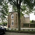
English: Beets, Beets 51 - Reformed Church - anno 15th century. The curch is partially secularised: the part beneath the tower is still used as church, the part in the asis is used by the local government.
Nederlands: Beets, Beets 51 - Hervormde Kerk - anno 15e eeuw. De kerk is gedeeltelijk geseculariseerd: het deel onder de toren is nog in gebruik als kerk, het deel in het apsis is in gebruik bij de burgerlijke gemeente.
Media in category "Nederlands Hervormde Kerk, Beets"
The following 83 files are in this category, out of 83 total.
-
Beets 51, Beets (Noord-Holland).JPG 640 × 480; 103 KB
-
Boom, raadszaal kerk Beets.JPG 2,592 × 3,888; 2.24 MB
-
Cuel de lampe orgel, Beets.jpg 3,888 × 2,592; 3.17 MB
-
Exterieur vanuit het noord-oosten - Beets - 20029961 - RCE.jpg 2,422 × 3,228; 2.29 MB
-
Exterieur vanuit het zuid-oosten - Beets - 20029959 - RCE.jpg 2,670 × 2,104; 2.72 MB
-
Exterieur vanuit het zuid-oosten - Beets - 20029960 - RCE.jpg 3,234 × 2,410; 2.36 MB
-
Geldkoffer in raadszaal in kerk van Beets.JPG 3,888 × 2,592; 3.74 MB
-
Gewelfschildering koor - Beets - 20029970 - RCE.jpg 1,200 × 938; 253 KB
-
Gewelfschildering koor - Beets - 20029971 - RCE.jpg 959 × 1,200; 287 KB
-
Graf Adriaan Boeli, Beets.JPG 2,592 × 3,888; 4.09 MB
-
Graf Klaas Kramer, Beets.JPG 2,592 × 3,888; 4.96 MB
-
Grafzerk, aanwezig in kerkmuseum in Janum - Beets - 20029979 - RCE.jpg 955 × 1,200; 298 KB
-
Herenbank, Beets.JPG 3,888 × 2,592; 3.2 MB
-
Interieur koor - Beets - 20029982 - RCE.jpg 1,190 × 1,200; 331 KB
-
Interieur koor - Beets - 20029983 - RCE.jpg 1,190 × 1,200; 371 KB
-
Interieur koor, oude fundamenten - Beets - 20029984 - RCE.jpg 1,192 × 1,200; 347 KB
-
Interieur schip, transept - Beets - 20029968 - RCE.jpg 773 × 1,200; 164 KB
-
Interieur schip, transept noord-zijde - Beets - 20029969 - RCE.jpg 782 × 1,200; 139 KB
-
Interieur, aanzicht orgel, orgelnummer 145 - Beets - 20369259 - RCE.jpg 856 × 1,200; 164 KB
-
Interieur, detail van gewelfschildering op houten gewelf - Beets - 20371701 - RCE.jpg 1,200 × 1,170; 278 KB
-
Interieur, detail van gewelfschildering op houten gewelf - Beets - 20371702 - RCE.jpg 1,200 × 1,200; 296 KB
-
Interieur, detail van gewelfschildering op houten gewelf - Beets - 20371704 - RCE.jpg 1,200 × 1,176; 316 KB
-
Interieur, detail van het beschilderd tongewelf - Beets - 20388565 - RCE.jpg 1,200 × 1,200; 215 KB
-
Interieur, detail van het beschilderd tongewelf - Beets - 20388566 - RCE.jpg 1,200 × 1,200; 245 KB
-
Interieur, detail van het beschilderd tongewelf - Beets - 20388567 - RCE.jpg 1,200 × 1,200; 199 KB
-
Interieur, naar het oosten - Beets - 20029975 - RCE.jpg 1,200 × 953; 207 KB
-
Interieur, naar het westen - Beets - 20029977 - RCE.jpg 1,200 × 965; 198 KB
-
Interieur, naar het westen - Beets - 20029978 - RCE.jpg 954 × 1,200; 203 KB
-
Interieur, overzicht richting het orgel - Beets - 20388562 - RCE.jpg 1,200 × 1,200; 361 KB
-
Interieur, overzicht van een grafzerk - Beets - 20388564 - RCE.jpg 1,200 × 1,200; 556 KB
-
Interieur, overzicht van herenbank - Beets - 20388560 - RCE.jpg 1,200 × 1,200; 324 KB
-
Interieur, overzicht van het beschilderd tongewelf - Beets - 20388561 - RCE.jpg 1,200 × 1,200; 329 KB
-
Kansel - Beets - 20029974 - RCE.jpg 946 × 1,200; 243 KB
-
Kerk van Beets.JPG 3,888 × 2,592; 5.21 MB
-
Koorkamer (vergaderplaats gemeenteraad) - Beets - 20029972 - RCE.jpg 1,200 × 946; 142 KB
-
Muur van kerk, Beets.JPG 2,592 × 3,888; 4.67 MB
-
Naamlijst predikanten, Beets.JPG 2,592 × 3,888; 3.05 MB
-
Noord-zijde - Beets - 20029962 - RCE.jpg 2,670 × 1,720; 807 KB
-
Noord-zijde - Beets - 20029963 - RCE.jpg 2,616 × 1,738; 923 KB
-
Noord-zijde - Beets - 20029964 - RCE.jpg 2,664 × 1,726; 1.24 MB
-
Noord-zijde - Beets - 20029965 - RCE.jpg 2,670 × 1,702; 1,015 KB
-
Orgel van kerk in Beets.JPG 2,592 × 3,888; 2.83 MB
-
Orgel west wand - Beets - 20029973 - RCE.jpg 2,469 × 3,057; 1.5 MB
-
Overzicht van de oostgevel - Beets - 20388545 - RCE.jpg 3,100 × 3,100; 2.38 MB
-
Overzicht van het achterste deel van de noordgevel - Beets - 20388546 - RCE.jpg 3,100 × 3,100; 2.12 MB
-
Overzicht van het achterste deel van de zuidgevel - Beets - 20388544 - RCE.jpg 3,100 × 3,100; 2.21 MB
-
Overzicht zuidoostgevel met zicht op het transept - Beets - 20388541 - RCE.jpg 3,100 × 3,100; 1.93 MB
-
Plafond kerk, Beets.jpg 3,888 × 2,592; 2.76 MB
-
Preekstoel, Beets.JPG 2,592 × 3,888; 2.98 MB
-
Raadszaal in kerk van Beets 01.JPG 3,888 × 2,592; 2.91 MB
-
Raadszaal in kerk van Beets 02.JPG 3,888 × 2,592; 3.51 MB
-
Signering gewelfschildering kerk Beets.JPG 3,888 × 2,592; 2.34 MB
-
Stoelen kerk Beets.JPG 3,888 × 2,592; 4.59 MB
-
Toren Beets 51, Beets (Noord-Holland).JPG 480 × 640; 93 KB
-
Toren Beets vanaf begraafplaats.JPG 2,592 × 3,888; 4.22 MB
-
Toren hervormde kerk, Beets.JPG 2,592 × 3,888; 3.34 MB
-
Vanuit het noord-westen - Beets - 20029966 - RCE.jpg 2,676 × 1,738; 1.14 MB
-
Vervolg naamlijst predikanten, Beets.JPG 2,592 × 3,888; 3.43 MB
-
Zerk, aanwezig in kerkmuseum in Janum - Beets - 20029980 - RCE.jpg 2,390 × 3,058; 1.91 MB
-
Zicht op Beets (met kerk) door Jacob Stellingwerff.jpg 964 × 860; 216 KB
-
Zicht op Beets (met kerk) door Jacob Stellingwerff2.jpg 2,403 × 1,592; 519 KB
-
Zicht op de zuidgevel met transept en ingangsportaal - Beets - 20388542 - RCE.jpg 3,100 × 3,100; 1.94 MB
-
Zuid wand - Beets - 20029976 - RCE.jpg 3,095 × 2,452; 1.85 MB
-
Zuid-zijde - Beets - 20029967 - RCE.jpg 2,670 × 1,726; 923 KB


