
Category:Nebraska Highway 39
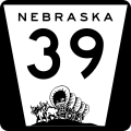
 | number: | (thirty-nine) |
|---|---|---|
| State highways in Nebraska: | 19 · 21 · 22 · 23 · 27 · 29 · 33 · 35 · 39 · 41 · 43 · 44 · 47 · 50 · 51 · 56 · 57 · 59 |
state highway in Nebraska, United States  | |||||
| Upload media | |||||
| Instance of | |||||
|---|---|---|---|---|---|
| Location | |||||
| Transport network | |||||
| Connects with |
| ||||
| Owned by | |||||
| Maintained by | |||||
| Inception |
| ||||
| Length |
| ||||
| Terminus | |||||
| Partially coincident with | |||||
 | |||||
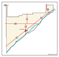
{{en|Media related to Nebraska Highway 39, a 42.05-mile (67.67 km) state highway in FNebraska, United States, that connects Nebraska Highway 92 (west of Osceola) with Nebraska Highway 14 (southeast of Albion).
Subcategories
This category has only the following subcategory.
Media in category "Nebraska Highway 39"
The following 3 files are in this category, out of 3 total.
-
 MerrickCounty.png 1,000 × 961; 82 KB
-
 N-39.svg 600 × 600; 126 KB
-
 Nebraska Highway 39 map.png 3,425 × 2,031; 596 KB
