Category:Mow Cop
Jump to navigation
Jump to search
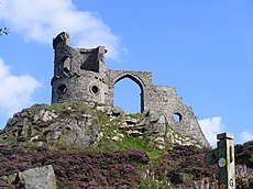
English: Mow Cop is a village on a high isolated hill. The village straddles the Cheshire - Staffordshire border, and in this capacity, is also divided between the North West and West Midlands regions of England.
village in United Kingdom split between Cheshire and Staffordshire | |||||
| Upload media | |||||
| Instance of | |||||
|---|---|---|---|---|---|
| Location | Kidsgrove, Newcastle-under-Lyme, Staffordshire, West Midlands, England | ||||
 | |||||
Subcategories
This category has the following 3 subcategories, out of 3 total.
Media in category "Mow Cop"
The following 52 files are in this category, out of 52 total.
-
A View of Cheshire - geograph.org.uk - 2261370.jpg 1,200 × 803; 929 KB
-
Cattle above Quarry Wood - geograph.org.uk - 846969.jpg 640 × 480; 311 KB
-
Cheshire Plains from Mow Cop - geograph.org.uk - 1481389.jpg 640 × 480; 63 KB
-
Cottages at Mow Cop - geograph.org.uk - 641499.jpg 640 × 480; 110 KB
-
Disused quarry on Mow Cop - geograph.org.uk - 5406052.jpg 4,032 × 3,024; 3.77 MB
-
Fly-tip at a beauty spot - geograph.org.uk - 1023694.jpg 640 × 480; 89 KB
-
Former quarry at Mow Cop - geograph.org.uk - 6080345.jpg 1,024 × 768; 198 KB
-
Former School, Mow Cop.jpg 1,024 × 768; 242 KB
-
From the rock outcrop, Mow Cop - geograph.org.uk - 847745.jpg 640 × 427; 96 KB
-
Ganister quarry - geograph.org.uk - 61831.jpg 640 × 480; 129 KB
-
Harriseahead from Mow Cop castle - geograph.org.uk - 6080495.jpg 1,024 × 768; 100 KB
-
Lane to Harriseahead - geograph.org.uk - 1023653.jpg 640 × 480; 79 KB
-
Looking down onto Mow Cop cave - geograph.org.uk - 1411123.jpg 640 × 428; 124 KB
-
Mouth of Mow Cop Cave - geograph.org.uk - 1411106.jpg 640 × 428; 74 KB
-
Mow Cop - geograph.org.uk - 1528027.jpg 640 × 436; 61 KB
-
Mow Cop - geograph.org.uk - 276457.jpg 640 × 480; 98 KB
-
Mow Cop car park - geograph.org.uk - 6080348.jpg 1,024 × 768; 155 KB
-
Mow Cop Looking for Wales (3056057666).jpg 1,067 × 800; 214 KB
-
Mow Cop transmitter - geograph.org.uk - 6080377.jpg 1,024 × 768; 77 KB
-
Mow Cop viewed from Congleton Road - geograph.org.uk - 1528417.jpg 640 × 428; 67 KB
-
Mow Cop Weslyan Chapel.jpg 4,000 × 3,000; 4.69 MB
-
Parson's Well, Mow Cop - geograph.org.uk - 1016502.jpg 640 × 480; 124 KB
-
Parson's Well, Mow Cop.jpg 4,000 × 3,000; 4.5 MB
-
Rock formation near Mow Cop Castle.jpg 5,888 × 3,925; 8.53 MB
-
Roe Park below Quarry Wood - geograph.org.uk - 846972.jpg 640 × 480; 294 KB
-
Sheep near Mow Cop - geograph.org.uk - 6080363.jpg 1,024 × 768; 299 KB
-
Slopes of Mow Cop - geograph.org.uk - 641828.jpg 640 × 480; 138 KB
-
Southeast from Mow Cop - geograph.org.uk - 641831.jpg 480 × 640; 113 KB
-
Squire's Well, Mow Cop - geograph.org.uk - 6080358.jpg 1,024 × 768; 309 KB
-
St.Luke's Church - geograph.org.uk - 5296391.jpg 1,600 × 1,200; 857 KB
-
The Bird in Hand, Kent Green - geograph.org.uk - 603995.jpg 639 × 430; 50 KB
-
The Gritstone Trail - geograph.org.uk - 856900.jpg 640 × 427; 98 KB
-
The Squires Well at Mow Cop - geograph.org.uk - 771124.jpg 480 × 640; 101 KB
-
Top Station Road, Mow Cop - geograph.org.uk - 3178512.jpg 640 × 480; 65 KB
-
View SE from Mow Cop Castle.jpg 6,000 × 4,000; 9.28 MB
-
View SW from Mow Cop Castle.jpg 5,892 × 3,928; 7.99 MB
-
View to Mow Cop - geograph.org.uk - 4296408.jpg 1,024 × 768; 287 KB
-
View towards Mow Cop - geograph.org.uk - 3625762.jpg 5,184 × 3,456; 3.82 MB
-
Wayside memorials - geograph.org.uk - 1735703.jpg 1,200 × 1,600; 325 KB
-
Wesleyan Memorial Church, Mow Cop - geograph.org.uk - 1016537.jpg 640 × 480; 72 KB
-
Castle Primary School - geograph.org.uk - 159098.jpg 640 × 480; 64 KB
-
Chapel St, Mount Pleasant - geograph.org.uk - 159144.jpg 640 × 480; 55 KB
-
Chapel, Mount Pleasant - geograph.org.uk - 159149.jpg 640 × 481; 94 KB
-
Cheshire's Close - geograph.org.uk - 61225.jpg 640 × 480; 66 KB
-
Limestone shaft - geograph.org.uk - 61833.jpg 640 × 480; 101 KB
-
Mow Cop Quarry and Village - geograph.org.uk - 124643.jpg 640 × 480; 114 KB
-
Mow Cop Riding Centre - geograph.org.uk - 230493.jpg 640 × 397; 92 KB
-
Remains of Tower Hill Colliery - geograph.org.uk - 53160.jpg 640 × 480; 125 KB
-
Wood Cottage, Moreton - geograph.org.uk - 185405.jpg 640 × 466; 71 KB
-
Wood Farm - geograph.org.uk - 185407.jpg 640 × 486; 65 KB


