Category:Mount Timpanogos Trail
Jump to navigation
Jump to search
hiking trail on Mount Timpanogos in Utah County, Utah, United States .jpg) | |||||
| Upload media | |||||
| Instance of | |||||
|---|---|---|---|---|---|
| Located in protected area |
| ||||
| Location | Utah County, Utah | ||||
| Maintained by | |||||
| Heritage designation | |||||
| Length |
| ||||
| Terminus | |||||
| Elevation above sea level |
| ||||
 | |||||
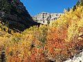
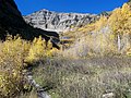
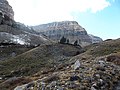
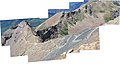
English: Media related to the Mount Timpanogos Trail (also known as the Aspen Grove Trail), a 6.04-mile (9.72 km) hiking trail (number 2052) on the east face of Mount Timpanogos, that connects Aspen Grove with the Mount Timpanogos Summit Trail (near the summit of Mount Timpanogos, above Emerald Lake).
The trail begins at Aspen Grove, within the Uinta-Wasatch-Cache National Forest near the Stewarts Cascades Trailhead, and heads westerly to quickly enter the Mount Timpanogos Wilderness (and continues within the wilderness for the remainder of it length). The trail climbs ascends the Primrose Cirque, with multiple switchbacks, before passing east then south of Roberts Horn. Just after passing north of Emerald Lake, the trail crosses the saddle and enters the Timpanogos Basin (at which point it connects with the south end of the Timpanooke Trail). Shortly thereafter the trail reaches the saddle with the western face of Mount Timpanogos, where the trail ends at a connection with the Timpanogos Summit Trail. (That trail continues north to end at the Timpanooke Trail and south to the summit of Mount Timpanogos, and then about 0.7 miles [1.1 km] beyond along the ridge line.) The Mount Timpanogos has elevation gain of about 4,725 feet (1,440 m) and there are two unnamed waterfalls along lower half of the trail. (Some maps incorrectly label both the Timpanogos Summit Trail and/or the Timpanooke Trail as being part of the Mount Timpanogos Trail.)
The trail begins at Aspen Grove, within the Uinta-Wasatch-Cache National Forest near the Stewarts Cascades Trailhead, and heads westerly to quickly enter the Mount Timpanogos Wilderness (and continues within the wilderness for the remainder of it length). The trail climbs ascends the Primrose Cirque, with multiple switchbacks, before passing east then south of Roberts Horn. Just after passing north of Emerald Lake, the trail crosses the saddle and enters the Timpanogos Basin (at which point it connects with the south end of the Timpanooke Trail). Shortly thereafter the trail reaches the saddle with the western face of Mount Timpanogos, where the trail ends at a connection with the Timpanogos Summit Trail. (That trail continues north to end at the Timpanooke Trail and south to the summit of Mount Timpanogos, and then about 0.7 miles [1.1 km] beyond along the ridge line.) The Mount Timpanogos has elevation gain of about 4,725 feet (1,440 m) and there are two unnamed waterfalls along lower half of the trail. (Some maps incorrectly label both the Timpanogos Summit Trail and/or the Timpanooke Trail as being part of the Mount Timpanogos Trail.)
Media in category "Mount Timpanogos Trail"
The following 23 files are in this category, out of 23 total.
-
 Mount Timpanogos from Mount Timpanogos Trail approaching the saddle.jpg 4,608 × 3,072; 3.61 MB
-
 Mount Timpanogos from the saddle.jpg 4,608 × 3,072; 3.63 MB
-
 Mount Timpanogos Mountain Goats - panoramio.jpg 4,288 × 3,216; 4.67 MB
-
 Mount Timpanogos Trail - panoramio (1).jpg 4,288 × 3,216; 11.13 MB
-
 Mount Timpanogos Trail - panoramio (13).jpg 4,288 × 3,216; 5.58 MB
-
 Mount Timpanogos Trail - panoramio (19).jpg 4,288 × 3,216; 5.68 MB
-
 Mount Timpanogos Trail - panoramio (2).jpg 4,288 × 3,216; 8.48 MB
-
 Mount Timpanogos Trail - panoramio (3).jpg 3,216 × 4,288; 9.36 MB
-
 Mount Timpanogos Trail - panoramio (4).jpg 4,288 × 3,216; 8.38 MB
-
 Mount Timpanogos Trail - panoramio (5).jpg 4,288 × 3,216; 9.03 MB
-
 Mount Timpanogos Trail - panoramio (6).jpg 4,288 × 3,216; 5.14 MB
-
 Mount Timpanogos Trail - panoramio (7).jpg 4,288 × 3,216; 6.36 MB
-
 Mount Timpanogos Trail - panoramio (8).jpg 4,288 × 3,216; 5.06 MB
-
 Mount Timpanogos Trail - panoramio (9).jpg 4,288 × 3,216; 5.57 MB
-
 Mount Timpanogos Trail - panoramio.jpg 4,288 × 3,216; 9.52 MB
-
 Mount Timpanogos Trail view 01, Sep 14.jpg 3,296 × 2,472; 1.13 MB
-
 Mount Timpanogos Trail view 02, Sep 14.jpg 3,296 × 2,472; 1.15 MB
-
 Mount Timpanogos with wild flowers 1.jpg 4,608 × 3,072; 3.6 MB
-
 Mount Timpanogos, UT.jpg 4,608 × 3,072; 3.53 MB
-
 MountTimpanogosTrail-s - Flickr - andrey zharkikh.jpg 9,093 × 4,898; 8.62 MB
-
 Panoramic View from Mount Timpanogos Saddle - panoramio.jpg 10,337 × 1,925; 11.73 MB
-
 Timpanooke Trail - panoramio (10).jpg 4,288 × 3,216; 5.72 MB
-
 Waterfall along Mount Timpanogos Trail, Jul 02.jpg 640 × 480; 68 KB


.jpg)
.jpg)
.jpg)
.jpg)
.jpg)
.jpg)
.jpg)
.jpg)
.jpg)
.jpg)


.jpg)
