Category:Mogollon Rim (Arizona transition zone)
Jump to navigation
Jump to search
Main Wikipedia article: Mogollon Rim.
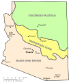
English: The Mogollon Rim transition zone of the Mogollon Plateau, across central Arizona.
- Part of the Colorado Plateau region of Arizona.
Subcategories
This category has the following 15 subcategories, out of 15 total.
F
H
M
O
P
S
T
V
W
Media in category "Mogollon Rim (Arizona transition zone)"
The following 24 files are in this category, out of 24 total.
-
Physiographic regions of Arizona.svg 664 × 768; 229 KB
-
Mogollon Rim east of Pine.jpg 1,938 × 1,938; 1.89 MB
-
Arizona Relief NED.jpg 422 × 500; 80 KB
-
Angel Thunder 2015, Interagency high angle rescue 150603-F-WQ860-195.jpg 4,256 × 2,832; 6.54 MB
-
Angel Thunder 2015, Interagency high angle rescue 150603-F-WQ860-216.jpg 4,256 × 2,832; 2.79 MB
-
Angel Thunder 2015, Interagency High Angle Rescue 150603-F-WQ860-219.jpg 4,256 × 2,832; 2.69 MB
-
Angel Thunder 2015, Interagency high angle rescue 150603-F-WQ860-245.jpg 4,256 × 2,832; 3.49 MB
-
Angel Thunder 2015, Interagency high angle rescue 150603-F-WQ860-264.jpg 4,256 × 2,832; 2.85 MB
-
Angel Thunder 2015, Interagency high angle rescue 150603-F-WQ860-267.jpg 4,256 × 2,832; 2.8 MB
-
Angel Thunder 2015, Interagency high angle rescue 150603-F-WQ860-308.jpg 4,256 × 2,832; 3.61 MB
-
Angel Thunder 2015, Interagency high angle rescue 150603-F-WQ860-350.jpg 4,256 × 2,832; 2.34 MB
-
Dude fire, 22 years later - panoramio.jpg 10,800 × 2,386; 16.39 MB
-
Knoll Lake660.jpg 3,480 × 2,292; 1.86 MB
-
Map of Arizona Precipitation NA.png 1,073 × 781; 222 KB
-
Pinus ponderosa StrawberryAZ.jpg 1,200 × 1,800; 1.09 MB
-
Ponderosa Forest.JPG 4,896 × 3,672; 6.73 MB
-
Red Rock-Secret Mtn Wilderness Map.JPG 508 × 724; 59 KB
-
Rough, steep trail to the top of the rim. - panoramio.jpg 3,264 × 2,448; 4.56 MB
-
Salt River Map.jpg 935 × 730; 435 KB
-
Sycamore Canyon from Barney Pasture.jpg 3,648 × 2,736; 2.9 MB
-
The Mogollon Rim northeast of Payson, Arizona.jpg 4,032 × 3,024; 3.7 MB
-
Map of Tonto National Monument.png 909 × 690; 168 KB
-
Wet Beaver Wilderness Map.JPG 518 × 730; 68 KB


