Category:Mines in Cornwall
Jump to navigation
Jump to search
Ceremonial counties of England: Cheshire · Cornwall · Cumbria · Derbyshire · Devon · Durham · Gloucestershire · Greater Manchester · Kent · Merseyside · North Yorkshire · Northumberland · Nottinghamshire · Somerset · South Yorkshire · Staffordshire · Tyne and Wear · Warwickshire · West Midlands · West Yorkshire ·
City-counties: Bristol ·
Former historic counties: Cumberland ·
Other former counties:
City-counties: Bristol ·
Former historic counties: Cumberland ·
Other former counties:
Wikimedia category | |||||
| Upload media | |||||
| Instance of | |||||
|---|---|---|---|---|---|
| Category combines topics | |||||
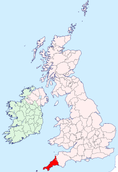
| Cornwall | |||||
historic county of England; Celtic nation | |||||
| Instance of | |||||
| Part of | |||||
| Location |
| ||||
| Capital | |||||
| Heritage designation | |||||
| Population |
| ||||
| Area |
| ||||
| Different from | |||||
| official website | |||||
 | |||||
Subcategories
This category has the following 50 subcategories, out of 50 total.
A
- Adits in Cornwall (11 F)
B
- Blue Hills Tin Mine (17 F)
- Bunny Mine (3 F)
C
- Carn Brea Mine (12 F)
- Carn Galver Mine (24 F)
- Carnon Mine (4 F)
- Cook's Kitchen Mine (5 F)
- Cooks Kitchen Mine (10 F)
- Crown Mines (23 F)
D
- Danescombe Mine (2 F)
- Ding Dong Mine, Cornwall (38 F)
- Dolcoath Mine (44 F)
- Drakewalls Mine (2 F)
E
- East Gunnislake Mine (1 F)
- East Pool Mine (23 F)
G
- Great Wheal Fortune (7 F)
- Great Work, Cornwall (3 F)
H
- Herodsfoot Mine (18 F)
K
- Killifreth Mine (18 F)
- King Edward Mine (45 F)
L
- Levant Higher Bal (5 F)
M
- Marke Valley Mine (2 F)
- Mine shafts in Cornwall (67 F)
- Minerals of Geevor Tin Mine (10 F)
O
- Old Gunnislake Mine (5 F)
P
- Penberthy Croft Mine (5 F)
- Poldark Mine, Cornwall (95 F)
- Poldory Mine (1 F)
- Port Quin Mine (2 F)
R
- Rosevanion Quarry (2 F)
S
- Seal Hole Mine (2 F)
T
- Tincroft Mine (21 F)
- Ting Tang Mine (4 F)
- Tregurtha Downs Mine (11 F)
- Tresavean Mine (1 F)
W
- Wheal Busy, Cornwall (10 F)
- Wheal Trewavas (23 F)
- Wheal Unity Wood Mine (7 F)
Media in category "Mines in Cornwall"
The following 200 files are in this category, out of 210 total.
(previous page) (next page)-
Baronet's engine house interior. - geograph.org.uk - 1313022.jpg 480 × 640; 62 KB
-
Batters' Shaft, West Chiverton - geograph.org.uk - 712665.jpg 640 × 427; 48 KB
-
Bellingham's Shaft Engine House - geograph.org.uk - 629295.jpg 640 × 425; 87 KB
-
Bread and Cheese Shaft, Nangiles - geograph.org.uk - 1234767.jpg 640 × 426; 95 KB
-
Calciner Stack at Grenville United Mine - geograph.org.uk - 529716.jpg 640 × 427; 120 KB
-
Calciners at Wheal Peevor - geograph.org.uk - 964244.jpg 640 × 480; 258 KB
-
Capped mine shaft at Wheal Plenty - geograph-2049813.jpg 640 × 480; 103 KB
-
Carn Galver tin mine ruins (21402259894).jpg 4,000 × 5,992; 3.22 MB
-
Carn Galver tin mine ruins (21402933114).jpg 4,000 × 2,667; 1.84 MB
-
Carn Galver tin mine ruins (21838371419).jpg 4,000 × 2,667; 936 KB
-
Carn Galver tin mine ruins (22013435562).jpg 2,667 × 4,000; 1.36 MB
-
Carn Galver tin mine ruins (22035612421).jpg 2,667 × 4,000; 1.04 MB
-
Chimney at Leswidden - geograph.org.uk - 1302439.jpg 640 × 427; 48 KB
-
Chimney at the bottom of the Moor - geograph.org.uk - 1452640.jpg 480 × 640; 84 KB
-
Chimney at Tolgarrick - geograph.org.uk - 1235085.jpg 640 × 480; 124 KB
-
Chimney in a field - geograph.org.uk - 912999.jpg 640 × 480; 272 KB
-
Chimney in the Mist - geograph.org.uk - 925875.jpg 427 × 640; 50 KB
-
Chimney on Carn Gloose - geograph.org.uk - 493141.jpg 640 × 427; 112 KB
-
Chimney south of Leswidden - geograph.org.uk - 1470175.jpg 640 × 427; 39 KB
-
Clouds at Wheal Coates (2785008954).jpg 2,560 × 1,712; 2.33 MB
-
Converted Engine House - geograph.org.uk - 228818.jpg 640 × 427; 93 KB
-
Disused buildings, Giew Mine - geograph.org.uk - 40676.jpg 640 × 480; 149 KB
-
Engine house - geograph.org.uk - 31776.jpg 480 × 640; 97 KB
-
Engine house at Porkellis - geograph.org.uk - 906432.jpg 480 × 640; 93 KB
-
Engine house at Tresowes Green - geograph.org.uk - 985660.jpg 480 × 640; 81 KB
-
Engine house at United Downs - geograph.org.uk - 809161.jpg 480 × 640; 80 KB
-
Engine house at United Downs - geograph.org.uk - 809171.jpg 640 × 480; 49 KB
-
Engine House at West Chiverton Mine - geograph.org.uk - 378974.jpg 480 × 640; 94 KB
-
Engine house at Wheal Ellen mine - geograph.org.uk - 1200071.jpg 480 × 640; 73 KB
-
Engine house at Wheal Ellen Mine - geograph.org.uk - 1200076.jpg 480 × 640; 57 KB
-
Engine House in Chapel Coombe - geograph.org.uk - 956125.jpg 480 × 640; 91 KB
-
Engine house near Tregarlands Farm - geograph.org.uk - 1051210.jpg 480 × 640; 102 KB
-
Engine house remains at Wheal Clifford - geograph.org.uk - 1051176.jpg 480 × 640; 103 KB
-
Engine House, Chapel Combe - geograph.org.uk - 68862.jpg 640 × 400; 79 KB
-
Engine House, Giew Mine (Tin) - geograph.org.uk - 942920.jpg 640 × 480; 69 KB
-
Engine Houses - geograph.org.uk - 491317.jpg 488 × 640; 147 KB
-
Engine houses at Wheal Dream, Wendron - geograph.org.uk - 867124.jpg 640 × 480; 43 KB
-
Engine Houses by Newton Road, Troon - geograph.org.uk - 173436.jpg 640 × 427; 83 KB
-
Giew Engine House 2.jpg 4,000 × 3,000; 5.45 MB
-
Giew Engine House.jpg 3,517 × 2,103; 2.1 MB
-
Giew Mine - geograph.org.uk - 298477.jpg 640 × 409; 118 KB
-
Giew Mine - geograph.org.uk - 38442.jpg 427 × 640; 130 KB
-
Goon Gumpas from Wheal Maid DSC 2951.jpg 1,600 × 1,065; 816 KB
-
Goonvean Cornish engine house - geograph.org.uk - 629782.jpg 428 × 640; 69 KB
-
Great Work Mine at sunset.jpg 3,024 × 4,032; 4.23 MB
-
Great Work Mine Leeds Shaft Engine House.jpg 4,032 × 3,024; 1.9 MB
-
Grenville New Stamps Engine House - geograph.org.uk - 535820.jpg 640 × 427; 72 KB
-
Gryll's Bunny mine working - geograph.org.uk - 1723663.jpg 640 × 480; 97 KB
-
Hallenbeagle Mine engine house - geograph.org.uk - 1236168.jpg 406 × 640; 84 KB
-
Hinds Shaft Pumping Engine House - geograph.org.uk - 353722.jpg 427 × 640; 83 KB
-
Holmbush Mine - geograph.org.uk - 1264863.jpg 640 × 427; 109 KB
-
Holmbush mine engine house and chimney.jpg 3,504 × 2,336; 5.99 MB
-
Houses and tin mining in Cornwall (21837493098).jpg 4,000 × 2,667; 1.71 MB
-
Isolated chimney in a field at Manhay - geograph.org.uk - 830548.jpg 640 × 480; 35 KB
-
Isolated chimney in a field at Manhay - geograph.org.uk - 830552.jpg 480 × 640; 35 KB
-
Just another old Cornish chimney - geograph.org.uk - 912172.jpg 640 × 480; 248 KB
-
Kenidjack Valley mine.jpg 3,024 × 4,032; 4.36 MB
-
Linkinhorne, Wheal Jenkin, Caradon Hill - geograph.org.uk - 715503.jpg 640 × 426; 112 KB
-
Mine adit at beach level at Rinsey Head - geograph.org.uk - 224030.jpg 640 × 480; 145 KB
-
Mine Buildings NE of Minions - geograph.org.uk - 1145862.jpg 640 × 480; 71 KB
-
Mine chimney and spoils tip, Blue Hills - geograph.org.uk - 73786.jpg 640 × 409; 125 KB
-
Mine Chimneys, Rosewall Hill - geograph.org.uk - 901325.jpg 640 × 424; 94 KB
-
Mine de cornouailles 2.jpg 710 × 564; 71 KB
-
Mine spoil heap in the Carnon Valley - geograph.org.uk - 1058739.jpg 640 × 480; 78 KB
-
Mineshaft warning sign.jpg 390 × 291; 39 KB
-
Mining Landscape - geograph.org.uk - 837635.jpg 640 × 427; 138 KB
-
Mining the lode - geograph.org.uk - 138287.jpg 427 × 640; 109 KB
-
Mining Waste Tips - geograph.org.uk - 472161.jpg 640 × 427; 114 KB
-
Nancegollan mine.jpg 850 × 563; 630 KB
-
Nangiles mine - geograph.org.uk - 1234737.jpg 640 × 426; 104 KB
-
New Roskear Mine - geograph.org.uk - 1192210.jpg 417 × 640; 93 KB
-
Old Lead Mine - geograph.org.uk - 171553.jpg 640 × 427; 102 KB
-
Old mine buildings east of Minions - geograph.org.uk - 1046379.jpg 640 × 480; 82 KB
-
Old mine buildings near Boscean - geograph.org.uk - 777115.jpg 640 × 480; 56 KB
-
Old Mine in the Kenidjack Valley - geograph.org.uk - 306580.jpg 640 × 426; 92 KB
-
Old mine workings at Tywarnhale Mine - geograph.org.uk - 1200059.jpg 480 × 640; 100 KB
-
Old mine workings nr Darite - geograph.org.uk - 1445811.jpg 640 × 480; 83 KB
-
Old tin mine, Cornwall (2530225295).jpg 1,920 × 2,560; 1.46 MB
-
Old tin mine, Cornwall (2531040324).jpg 1,920 × 2,560; 1.49 MB
-
Parkandillick Cornish Beam Engine - geograph.org.uk - 264287.jpg 640 × 420; 99 KB
-
Phoenix Mine - geograph.org.uk - 797089.jpg 640 × 419; 74 KB
-
Phoenix Mine, Prince of Wales Shaft - geograph.org.uk - 849011.jpg 480 × 640; 72 KB
-
Poldice Mine Gwennap Cornwall.jpg 1,600 × 1,200; 1.32 MB
-
Prince of Wales Shaft engine house - geograph.org.uk - 629281.jpg 424 × 640; 95 KB
-
Pumping engine house at Wheal Peevor - geograph.org.uk - 801110.jpg 480 × 640; 62 KB
-
Restored engine house near Northwood - geograph.org.uk - 711246.jpg 640 × 444; 68 KB
-
Rinsey mine stack.jpg 1,365 × 2,048; 412 KB
-
South Fowey Consols Mine - geograph.org.uk - 1756590.jpg 640 × 424; 80 KB
-
South Polgooth - geograph.org.uk - 712599.jpg 640 × 427; 48 KB
-
South Polgooth Mine - geograph.org.uk - 712578.jpg 640 × 427; 78 KB
-
Spoilheaps of South Caradon Mine - geograph.org.uk - 1121917.jpg 640 × 428; 53 KB
-
Stamps Engine House at Wheal Peevor - geograph.org.uk - 801107.jpg 480 × 640; 58 KB
-
Stoke Climsland, South Kit Hill Mine - geograph.org.uk - 1221952.jpg 640 × 427; 350 KB
-
The ruined Greenburrow engine house - geograph.org.uk - 935760.jpg 427 × 640; 92 KB
-
The Southern Slope of Kit Hill - geograph.org.uk - 1265999.jpg 640 × 427; 133 KB
-
Tredinneck engine house - geograph.org.uk - 1274520.jpg 480 × 640; 124 KB
-
Trengwainton Pump House.jpg 3,024 × 4,032; 7.62 MB
-
Trew Parc and Sea View Terrace, Redruth, August 2022.jpg 4,032 × 3,024; 7.63 MB
-
Trimming tin stone, East Pool Mine.jpg 960 × 613; 127 KB
-
Ventonwyn Mine - geograph.org.uk - 712631.jpg 640 × 427; 75 KB
-
Watch Croft - Garden Mine (01).jpg 3,024 × 4,032; 4.9 MB
-
Watch Croft - Garden Mine (02).jpg 3,456 × 4,608; 4.4 MB
-
Watch Croft - Garden Mine (03).jpg 3,024 × 4,032; 4.19 MB
-
Watch Croft - Garden Mine (04).jpg 3,024 × 4,032; 3.37 MB
-
West Godolphin mine - geograph.org.uk - 665980.jpg 468 × 640; 85 KB
-
Wheal Bush - geograph.org.uk - 1236059.jpg 640 × 381; 75 KB
-
Wheal Bush - geograph.org.uk - 589347.jpg 640 × 360; 65 KB
-
Wheal Edward Stamps - geograph.org.uk - 491312.jpg 640 × 427; 74 KB
-
Wheal Friendly Engine House Remains - geograph.org.uk - 534553.jpg 427 × 640; 100 KB
-
Wheal Hearle pump engine house - geograph.org.uk - 1065687.jpg 480 × 640; 51 KB
-
Wheal Jenkins - geograph.org.uk - 629296.jpg 640 × 430; 85 KB
-
Wheal Kitty - geograph.org.uk - 179004.jpg 640 × 411; 100 KB
-
Wheal Pool, Helston.jpg 3,024 × 4,032; 6.59 MB
-
Wheal Prosper Mine Engine House, Rinsey Head, Cornwall (18614824213).jpg 3,216 × 4,288; 3.75 MB
-
Wheal Prosper Mine Engine House, Rinsey Head, Cornwall (19047745600).jpg 3,216 × 4,288; 3.62 MB
-
Wheal Prosper ^ Rinsey. - panoramio.jpg 2,992 × 2,992; 4.17 MB
-
Wheal Prosper. - panoramio.jpg 2,992 × 2,992; 4.04 MB
-
Wheal Rose - geograph.org.uk - 912186.jpg 640 × 480; 240 KB
-
Wheal Speedwell copper mine.jpg 3,024 × 4,032; 3.24 MB
-
Wheal Speedwell looking east.jpg 3,024 × 4,032; 6.35 MB
-
Wheal Speedwell, Prussia Cove.jpg 4,032 × 3,024; 6.32 MB
-
Wheal Trevega. - panoramio.jpg 3,648 × 2,736; 5.75 MB
-
Wheal Unity mine in Cornwall.jpg 2,592 × 1,944; 918 KB
-
Wheal Uny - geograph.org.uk - 1359416.jpg 640 × 426; 92 KB
-
Wheal Vyvyan, Constantine (DSCN0534).jpg 1,632 × 1,224; 890 KB
-
Woolf's Engine House - geograph.org.uk - 535835.jpg 640 × 427; 68 KB
-
You have been warned^ - geograph.org.uk - 138277.jpg 640 × 427; 112 KB
-
Arsenic Flue at Botallack Mine - geograph.org.uk - 490371.jpg 640 × 427; 112 KB
-
Arsenic Flues at Botallack Mine - geograph.org.uk - 490352.jpg 640 × 427; 97 KB
-
Blue Hills Tin Streams - geograph.org.uk - 1447321.jpg 640 × 423; 93 KB
-
Derelict Mine Buildings near Trevega - geograph.org.uk - 47997.jpg 640 × 360; 71 KB
-
Disused mine buildings near Kelly Bray - geograph.org.uk - 470224.jpg 640 × 426; 115 KB
-
East Wheal Lovell Engine house - geograph.org.uk - 339029.jpg 640 × 480; 72 KB
-
Engine House at Dolcoath Mine - geograph.org.uk - 97722.jpg 640 × 477; 71 KB
-
Engine House at South Tincroft Mine - geograph.org.uk - 355151.jpg 640 × 427; 88 KB
-
Engine house chimneys at Botallack - geograph.org.uk - 712272.jpg 640 × 606; 140 KB
-
Engine House near Carnkie - geograph.org.uk - 353942.jpg 640 × 427; 90 KB
-
Engine House, near Goonearl - geograph.org.uk - 88924.jpg 480 × 640; 53 KB
-
Engine House, Wheal Rose - geograph.org.uk - 88922.jpg 480 × 640; 91 KB
-
Engine Houses, Wheal Peevor - geograph.org.uk - 98691.jpg 640 × 470; 61 KB
-
Enginehouse, South Polgooth - geograph.org.uk - 712608.jpg 427 × 640; 66 KB
-
Entrance to a Mining Adit - geograph.org.uk - 138272.jpg 640 × 427; 133 KB
-
Eroded Mining Waste Tip on the Cliff Top - geograph.org.uk - 472196.jpg 640 × 425; 103 KB
-
Five Turnings - geograph.org.uk - 289874.jpg 640 × 427; 82 KB
-
Grenville United Mines - geograph.org.uk - 23328.jpg 640 × 479; 81 KB
-
Gunnislake Clitters Mine - geograph.org.uk - 32078.jpg 640 × 480; 123 KB
-
Industrial Remains - geograph.org.uk - 647883.jpg 640 × 480; 119 KB
-
Jope's Shaft Pumping Engine House - geograph.org.uk - 549621.jpg 426 × 640; 115 KB
-
Kitto's Shaft, South Caradon Mine - geograph.org.uk - 548780.jpg 640 × 427; 109 KB
-
Mine Chimney at Wheal Eliza Consols - geograph.org.uk - 77232.jpg 480 × 640; 152 KB
-
Mine Engine House - geograph.org.uk - 223937.jpg 640 × 427; 72 KB
-
Mine Engine Houses and Pasture - geograph.org.uk - 172781.jpg 640 × 387; 77 KB
-
Mine Shaft Cover in the Poldice Valley - geograph.org.uk - 145549.jpg 640 × 453; 148 KB
-
Mine Waste Tip by the Footpath - geograph.org.uk - 366944.jpg 640 × 480; 123 KB
-
Mine workings near Watergate Highertown - geograph.org.uk - 681572.jpg 640 × 480; 114 KB
-
Mining Area - geograph.org.uk - 288580 (cropped).jpg 576 × 384; 115 KB
-
Mining Area - geograph.org.uk - 288580.jpg 640 × 427; 136 KB
-
Mining Waste near Kitto's Shaft - geograph.org.uk - 549159.jpg 640 × 427; 106 KB
-
Old mine - geograph.org.uk - 517772.jpg 480 × 640; 169 KB
-
Old Paving near a mineshaft - geograph.org.uk - 471319.jpg 640 × 427; 177 KB


