Category:Michaeliskirche Jämlitz
Jump to navigation
Jump to search
| Object location | | View all coordinates using: OpenStreetMap |
|---|
This is the category of the Brandenburger Baudenkmal (cultural heritage monument) with the ID 09125434 (Wikidata)
|
church building in Brandenburg state, Germany | |||||
| Upload media | |||||
| Instance of | |||||
|---|---|---|---|---|---|
| Location | Jämlitz, Jämlitz-Klein Düben, Spree-Neiße District, Brandenburg, Germany | ||||
| Heritage designation | |||||
| Inception |
| ||||
 | |||||

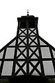
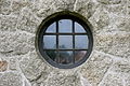
Deutsch: Michaeliskirche, erbaut 1952/1953; massive Bauweise aus Granit mit Fachwerkaufbau; Satteldach mit Schieferdeckung; Entwurf wahrscheinlich von Architekt Albert Meyer; Baudenkmal
English: Michaelis church, built 1952/1953; massive construction made of granite with truss structure on top; Gable roof with slate roofing; Designed probably by architect Albert Meyer; building monument
Media in category "Michaeliskirche Jämlitz"
The following 6 files are in this category, out of 6 total.
-
 Jämlitz Kirche.jpg 2,736 × 3,648; 1.9 MB
-
 Jämlitz, die Dorfkirche.jpg 2,551 × 1,701; 1.21 MB
-
 Jämlitz-Klein Düben - Schulstraße - Kirche 01 ies.jpg 3,888 × 2,592; 1.71 MB
-
 Jämlitz-Klein Düben - Schulstraße - Kirche 02 ies.jpg 3,888 × 2,592; 1.67 MB
-
 Jämlitz-Klein Düben - Schulstraße - Kirche 03 ies.jpg 2,592 × 3,888; 989 KB
-
 Jämlitz-Klein Düben - Schulstraße - Kirche 04 ies.jpg 3,888 × 2,592; 2.46 MB


