Category:Methley Joint Railway
Jump to navigation
Jump to search
UK railway line | |||||
| Upload media | |||||
| Instance of |
| ||||
|---|---|---|---|---|---|
| Location |
| ||||
| Owned by | |||||
| |||||
Subcategories
This category has the following 2 subcategories, out of 2 total.
R
- Methley Joint Railway RJD (1 F)
Media in category "Methley Joint Railway"
The following 28 files are in this category, out of 28 total.
-
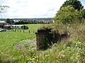
 Abutment of demolished Methley Joint railway bridge - geograph.org.uk - 6481561.jpg 1,600 × 1,200; 825 KB
-
 Abutments of a Methley Joint railway bridge - geograph.org.uk - 6480995.jpg 1,600 × 1,200; 853 KB
-

-
 Controlling access - geograph.org.uk - 2014558.jpg 1,024 × 768; 173 KB
-
 Controlling footpath use - geograph.org.uk - 2014410.jpg 1,024 × 768; 300 KB
-
 Cycle Track - Langdale Avenue - geograph.org.uk - 3805121.jpg 640 × 480; 136 KB
-
 Fly tipping - geograph.org.uk - 978659.jpg 486 × 640; 154 KB
-
 Former Methley Joint railway - geograph.org.uk - 2014395.jpg 1,024 × 768; 254 KB
-
 Former railway - geograph.org.uk - 2013476.jpg 1,024 × 768; 199 KB
-
 Former railway line passing under M62 - geograph.org.uk - 2014436.jpg 1,024 × 768; 257 KB
-
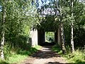
 Guarding the Trail - geograph.org.uk - 2013503.jpg 1,024 × 768; 230 KB
-
 Junction on footpath and cycleway - geograph.org.uk - 2014548.jpg 1,024 × 768; 219 KB
-
 Looking west on the Methley Joint railway - geograph.org.uk - 6481000.jpg 1,600 × 1,200; 791 KB
-
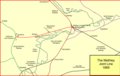 Methley joint.png 1,224 × 771; 78 KB
-
 National Cycle Network signpost, Methly Lanes (geograph 6668506).jpg 551 × 755; 282 KB
-
 Site of dropped bridge, Trans Pennine Trail - geograph.org.uk - 6480969.jpg 1,600 × 1,200; 706 KB
-
 The former Methley Joint railway - geograph.org.uk - 2015400.jpg 1,024 × 768; 205 KB
-
 The former Methley Joint railway line - geograph.org.uk - 2015367.jpg 1,024 × 768; 146 KB
-
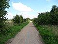
 The Trans Pennine Trail - geograph.org.uk - 2013450.jpg 1,024 × 768; 170 KB
-
 Track - Bottom Boat Road - geograph.org.uk - 4321573.jpg 640 × 480; 131 KB
-
 Track - Bottom Boat Road - geograph.org.uk - 4321722.jpg 640 × 480; 101 KB
-
 Track - Sheridan Street - geograph.org.uk - 3805472.jpg 640 × 480; 113 KB
-
 Track - Sheridan Street - geograph.org.uk - 3805473.jpg 640 × 480; 103 KB
-
 Trans Pennine Trail - geograph.org.uk - 2015412.jpg 1,024 × 768; 200 KB
-
 Trans Pennine Trail approaching Meadowfield Rise - geograph.org.uk - 6480681.jpg 1,600 × 1,200; 602 KB
-
 Tree alongside the former railway line - geograph.org.uk - 2015043.jpg 1,024 × 768; 170 KB
-
 Tree alongside the Trans Pennine Trail - geograph.org.uk - 2015059.jpg 1,024 × 768; 164 KB
-
 Where's the bridge gone^ - geograph.org.uk - 2014264.jpg 1,024 × 768; 191 KB


.jpg)


Categories:
- Defunct rail transport companies of the United Kingdom
- British joint railway companies
- Great Northern Railway (Great Britain)
- Lancashire and Yorkshire Railway
- London and North Eastern Railway
- London, Midland and Scottish Railway
- North Eastern Railway jointly operated lines
- Disused railway lines in West Yorkshire