Category:March 2021 in Norfolk, England
Jump to navigation
Jump to search
Ceremonial counties of England: Berkshire · Buckinghamshire · Cambridgeshire · Cheshire · Cornwall · Derbyshire · Devon · Dorset · Durham · East Riding of Yorkshire · East Sussex · Essex · Gloucestershire · Greater London · Greater Manchester · Lancashire · Leicestershire · Lincolnshire · Merseyside · Norfolk · North Yorkshire · Northamptonshire · Oxfordshire · Somerset · South Yorkshire · Staffordshire · Surrey · Tyne and Wear · Warwickshire · West Midlands · West Sussex · West Yorkshire · Worcestershire
City-counties: Bristol ·
Former historic counties:
Other former counties:
City-counties: Bristol ·
Former historic counties:
Other former counties:
Deutsch: Bilder, die im März 2021 in Norfolk, England aufgenommen worden sind. Bitte beachten Sie, dass dies weder das Datum des Uploads noch das Datum des Scannens eines Fotos ist.
English: Images/pictures taken in Norfolk, England during March 2021. Note this is not the date of the upload, nor the date a photo was scanned.
Español: Fotografías o imágenes tomadas en Norfolk, England durante marzo 2021. No es la fecha de subida ni escaneo, sino la fecha en que las fotografías o imágenes se crearon.
Esperanto: Bildoj faritaj en Norfolk, England en marto 2021. Tio ne estas la dato, kiam la bildoj estis alŝutitaj aŭ skanitaj.
Français : Photographies ou images prises en Norfolk, England durant mars 2021. Ce n'est pas la date du téléchargement ou du scan.
Galego: Fotografías ou imaxes tomadas en Norfolk, England durante marzo 2021. Non é a data de subida nin escaneamento, senón a data na que se crearon as fotografías ou imaxes.
Italiano: Fotografie o immagini scattate a Norfolk, England nel marzo 2021. Nota bene: la data non si riferisce né a quella di upload né a quella in cui la foto è stata digitalizzata.
Norsk bokmål: Bilder tatt i Norfolk, England i løpet av mars 2021. Merk at dette ikke er datoen for opplasting, eller når et bilde har blitt skannet.
Norsk nynorsk: Bilete teke i Norfolk, England i løpet av mars 2021. Merk at dette ikkje er datoen for opplasting, eller når eit bilete har vorte skanna.
Русский: Изображения, сделанные в Norfolk, England в течение март 2021 (не дата загрузки изображения).
Українська: Зображення, зроблені в Norfolk, England протягом березень 2021. Зауважте, що це не дата завантаження чи дата сканування фотографії.
| March 2020 | ← | March 2021 | → | March 2022 | |||||||
| Jan | Feb | Mar | Apr | May | Jun | Jul | Aug | Sep | Oct | Nov | Dec |
| 230 | 179 | 244 | 100 | 121 | 219 | 209 | 191 | 322 | 291 | 198 | 295 |
|---|---|---|---|---|---|---|---|---|---|---|---|
Subcategories
This category has the following 3 subcategories, out of 3 total.
N
Media in category "March 2021 in Norfolk, England"
The following 200 files are in this category, out of 241 total.
(previous page) (next page)-
 -2021-03-05 Bus stop shelter, Knapton Green, Norfolk.jpg 1,024 × 768; 277 KB
-
 -2021-03-07 Road Junction on Dilham Road, Honing.jpg 1,024 × 768; 317 KB
-
 -2021-03-13 Round hay bales, East Ruston, Norfolk.jpg 1,024 × 768; 180 KB
-
 -2021-03-01 Saint Martin’s parish church, Overstrand, Norfolk.JPG 5,152 × 3,864; 4.45 MB
-
 -2021-03-01 Street name sign, Northrepps Road, Overstrand, Norfolk.JPG 4,933 × 3,699; 3.4 MB
-
 -2021-03-03 Country Lane, Felmingham.JPG 5,152 × 3,864; 6.89 MB
-
 -2021-03-07 Bittern Line bridge, Northrepps.JPG 5,152 × 3,864; 7.35 MB
-
 -2021-03-07 Foundry Arms, Church street, Northrepps.JPG 5,152 × 3,864; 4.64 MB
-
 -2021-03-07 Gallus Close, Northrepps, Norfolk.JPG 5,152 × 3,864; 4.86 MB
-
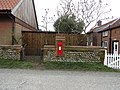 -2021-03-08 Brick pier mounted Royal Mail Post Box, The Street, Knapton.JPG 5,152 × 3,864; 7.14 MB
-
 -2021-03-08 Saint Peter and Saint Paul, Knapton.JPG 5,152 × 3,864; 4.77 MB
-
 -2021-03-08 Street name sign, The Street, Knapton.JPG 5,152 × 3,864; 6.98 MB
-
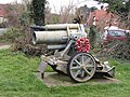 -2021-03-09 1917 World War One 250mm mortar gun, Honing, Norfolk (1).JPG 5,152 × 3,864; 7.93 MB
-
 -2021-03-09 1917 World War One 250mm mortar gun, Honing, Norfolk (2).JPG 5,152 × 3,864; 7.78 MB
-
 -2021-03-09 Detail-Honing railway bridge, Weavers' Way, Honing.JPG 5,152 × 3,864; 6.39 MB
-
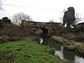 -2021-03-09 Dilham Bridge ove the North Walsham & Dilham canal, Honing (2).JPG 5,152 × 3,864; 6.27 MB
-
 -2021-03-09 Honing railway bridge, Weavers' Way, Honing (1).JPG 5,152 × 3,864; 9.32 MB
-
 -2021-03-09 Honing railway bridge, Weavers' Way, Honing (2).JPG 5,152 × 3,864; 8.58 MB
-
 -2021-03-09 Honing railway bridge, Weavers' Way, Honing (3).JPG 5,152 × 3,864; 8.04 MB
-
 -2021-03-09 Honing railway bridge, Weavers' Way, Honing (4).JPG 5,152 × 3,864; 8.82 MB
-
 -2021-03-09 Looking across Dilham Bridge ove the North Walsham & Dilham canal, Honing.JPG 5,152 × 3,864; 7.91 MB
-
 -2021-03-09 Looking along a section of Weavers' Way, Honing, Norfolk (1).JPG 5,152 × 3,864; 9.29 MB
-
 -2021-03-09 Looking along a section of Weavers' Way, Honing, Norfolk (2).JPG 5,152 × 3,864; 9.55 MB
-
 -2021-03-09 Looking along a section of Weavers' Way, Honing, Norfolk (3).JPG 5,152 × 3,864; 9.08 MB
-
 -2021-03-09 Looking along a section of Weavers' Way, Honing, Norfolk (4).JPG 5,152 × 3,864; 9.36 MB
-
 -2021-03-09 North Walsham & Dilham canal, Honing (1).JPG 5,152 × 3,864; 9.44 MB
-
 -2021-03-09 North Walsham & Dilham canal, Honing (2).JPG 5,152 × 3,864; 10.05 MB
-
 -2021-03-09 Plaque, 1917 World War One 250mm mortar gun, Honing, Norfolk.JPG 5,152 × 3,864; 5.93 MB
-
 -2021-03-09 Red Royal Mail post box, Meeting House Hill Road.JPG 4,493 × 3,370; 4.43 MB
-
 -2021-03-09 Semi detached Airey house, East Ruston Road, Honing (1).JPG 5,152 × 3,864; 5.62 MB
-
 -2021-03-09 Semi detached Airey house, East Ruston Road, Honing (2).JPG 5,152 × 3,864; 5.63 MB
-
 -2021-03-09 Semi detached Airey house, East Ruston Road, Honing (3).JPG 5,152 × 3,864; 4.84 MB
-
 -2021-03-09 WWI pillbox, Windmill Road, Honing.JPG 5,152 × 3,864; 8.81 MB
-
 -2021-03-10 Bluebelles gift shop, High Street, Mundesley.JPG 5,152 × 3,864; 4.62 MB
-
 -2021-03-10 Brick and flint house, Beach Road, Mundesley.JPG 5,152 × 3,864; 4.22 MB
-
 -2021-03-10 Coastwatch lookout, Mundesley.JPG 5,152 × 3,864; 4.46 MB
-
 -2021-03-11 Footpath and gateway, Northrepps Road, Overstrand.JPG 3,864 × 5,152; 7.91 MB
-
 -2021-03-11 Sheep on a hillside, Northrepps Road, Overstrand.JPG 3,864 × 5,152; 8.33 MB
-
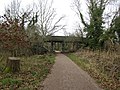
 -2021-03-13 Access steps to the Bittern Line from Hall Road, Northrepps.JPG 5,152 × 3,864; 6.24 MB
-
 -2021-03-13 Small feild next to Hall Road, Northrepps.JPG 5,152 × 3,864; 6.37 MB
-
 -2021-03-13 Watitrose supermarket, North Walsham.JPG 4,735 × 3,551; 2.94 MB
-
 -2021-03-13 White thatched cottage, Hall Road, Northrepps.JPG 5,152 × 3,864; 6.2 MB
-
 -2021-03-14 Briggate towermill, Windmill Road, Briggate, Norfolk (1).JPG 3,864 × 5,152; 6.07 MB
-
 -2021-03-14 Briggate towermill, Windmill Road, Briggate, Norfolk (2).JPG 5,152 × 3,864; 7.95 MB
-
 -2021-03-14 Briggate towermill, Windmill Road, Briggate, Norfolk (3).JPG 3,864 × 5,152; 8.61 MB
-
 -2021-03-14 Bus stop shelter, Knapton Green, Norfolk.JPG 5,152 × 3,864; 4.98 MB
-
 -2021-03-14 Cattle and horse pens next to the old railway station, Honing (1).JPG 5,152 × 3,864; 8.82 MB
-
 -2021-03-14 Cattle and horse pens next to the old railway station, Honing (2).JPG 5,152 × 3,864; 7.83 MB
-
 -2021-03-14 Cattle and horse pens next to the old railway station, Honing (3).JPG 5,152 × 3,864; 8.63 MB
-
 -2021-03-14 Derelict Railwaymans Bothy, Honing Railway Station, Norfolk (1).JPG 5,152 × 3,864; 9.33 MB
-
 -2021-03-14 Derelict Railwaymans Bothy, Honing Railway Station, Norfolk (2).JPG 5,152 × 3,864; 7.58 MB
-
-
 -2021-03-14 Disused railway bridge, Knapton.JPG 5,152 × 3,864; 4.67 MB
-
 -2021-03-14 North Walsham and Dilham Canal, Briggate, Norfolk.JPG 5,152 × 3,864; 8.37 MB
-
 -2021-03-14 St Peter and St Paul church, Honing, Norfolk.JPG 5,152 × 3,864; 5.18 MB
-
 -2021-03-14 Street name sign, East Ruston Road, Honing, Norfolk.JPG 5,152 × 3,864; 8.41 MB
-

-

-

-
 -2021-03-14 Weavers’ Way, Honing railway station, Norfolk.JPG 5,152 × 3,864; 9.05 MB
-
 -2021-03-14 Witton and Ridlinghton Village Hall, Witton, Norfolk.JPG 5,152 × 3,864; 7.15 MB
-
 -2021-03-15 Fire hydrant marker post, Heath Road, Crostwight, Norfolk.JPG 3,864 × 5,152; 7.89 MB
-
 -2021-03-15 Meadow adjacent to Crostwight Heath.JPG 5,152 × 3,864; 6.32 MB
-
 -2021-03-15 School Road, East Ruston.JPG 5,152 × 3,864; 6.01 MB
-
 -2021-03-15 Street name sign, Meeting Hill Road, Briggate.JPG 5,152 × 3,864; 7.53 MB
-
 -2021-03-15 Street name sign, Oak Lane, East Ruston.JPG 5,152 × 3,864; 5.89 MB
-
 -2021-03-15 Victorian post box, Station Road, Briggate, Norfolk.JPG 3,864 × 5,152; 6.66 MB
-
 -2021-03-18 Gas pipeline marker sign, Hall Lane, Knapton.JPG 3,864 × 5,152; 8.12 MB
-
 -2021-03-18 Looking north along Hall Lane, Knapton.JPG 3,864 × 5,152; 4.97 MB
-
 -2021-03-18 New houses on Hornbeam Road, North Walsham.JPG 5,125 × 1,141; 1.11 MB
-
 -2021-03-18 Paston Way, Knapton.JPG 3,864 × 5,152; 5.86 MB
-
 -2021-03-18 Ploughed feild next to Paston Way, Knapton (1).JPG 5,152 × 3,864; 5.19 MB
-
 -2021-03-18 Ploughed feild next to Paston Way, Knapton (2).JPG 5,152 × 3,864; 5.57 MB
-
 -2021-03-18 Toolstation, Hornbeam Road, North Walsham.JPG 5,152 × 3,864; 4.66 MB
-
 -2021-03-20 A drainage ditch around the edge of a feild, Trunch, England.JPG 5,152 × 3,864; 8.65 MB
-
 -2021-03-20 A Gas pipeline marker post on the edge of a feild, Trunch, England.JPG 5,152 × 3,864; 7.74 MB
-
 -2021-03-20 A remoat view of Trunch church tower, Norfolk.JPG 5,152 × 3,864; 4.79 MB
-
 -2021-03-20 A view across a ploughed feild, Trunch, England.JPG 5,152 × 3,864; 5.44 MB
-
 -2021-03-20 Country Lane north east of Trunch, Norfolk (1).JPG 3,864 × 5,152; 8.07 MB
-
 -2021-03-20 Country Lane north east of Trunch, Norfolk (2).JPG 3,864 × 5,152; 7.99 MB
-
 -2021-03-20 Footpath alongside a feild boundary, Trunch, England (1).JPG 3,864 × 5,152; 8.37 MB
-
 -2021-03-20 Footpath alongside a feild boundary, Trunch, England (2).JPG 5,152 × 3,864; 6.74 MB
-
 -2021-03-20 King George VI post boxes, Frogshall, Norfolk.JPG 3,864 × 5,152; 5.52 MB
-
 -2021-03-20 Primroses (primula vulgaris), Trunch, England.JPG 5,152 × 3,864; 4.83 MB
-
 -2021-03-20 Tree lined field boundary, Trunch, England.JPG 5,152 × 3,864; 6.57 MB
-
 -2021-03-23 McDonalds under construction, Middlebrook Way, Cromer.JPG 5,152 × 3,864; 5.31 MB
-
 -2021-03-24 Victorian pillar box, Cliff Road, Cromer.JPG 735 × 1,133; 264 KB
-
 -2021-03-29 Feltwell village sign, Oak Street, Feltwell (1).jpg 3,072 × 3,072; 4.27 MB
-
 -2021-03-29 Feltwell village sign, Oak Street, Feltwell.jpg 3,068 × 3,068; 4.03 MB
-
 -2022-01-05 Saint Martin’s parish church, Norfolk.JPG 5,152 × 3,864; 7 MB
-
 -2021-03-14 Royal Mail post box, Walcott Road, Bacton.JPG 3,669 × 4,891; 4.07 MB
-
 -2021-03-29 Converted farm buildings along Mill Common Road, Witton, Norfolk.jpg 1,024 × 768; 235 KB
-
 -2021-03-29 North along Mill Common Road, Witton, Norfolk.jpg 1,024 × 768; 283 KB
-
 -2021-03-29 South along Mill Common Road, Witton, Norfolk.jpg 1,024 × 768; 229 KB
-
 -2021-01-29 Redundant railway bridge, Paston Way, Swafield, Norfolk.jpg 1,024 × 768; 298 KB
-
 -2021-03-14 Arching tree inside Bacton Wood, Norfolk.jpg 1,024 × 768; 392 KB
-
 -2021-03-14 Looking east along the North boundary of Bacton Wood, Norfolk.jpg 1,024 × 768; 299 KB
-
 -2021-03-14 North boundary of Bacton Wood, Norfolk.jpg 1,024 × 768; 266 KB
-
 -2021-03-15 Countryside towards Spa Common, Norfolk.jpg 1,024 × 768; 321 KB
-
 -2021-03-17 Tucks Road, Bengate, Norfolk.jpg 1,024 × 768; 244 KB
-
 -2021-03-19 Anchor Street, Smallburgh, Norfolk (1).jpg 1,024 × 768; 320 KB
-
 -2021-03-19 Farm track off Anchor Street, Smallburgh, Norfolk.jpg 1,024 × 768; 315 KB
-
 -2021-03-19 Footpath into a woodland, Smallburgh, Norfolk.jpg 1,024 × 768; 417 KB
-
 -2021-03-19 Ploughed field, Smallburgh, Norfolk.jpg 1,024 × 768; 320 KB
-

-
 -2021-03-10 Meeting House Hill Road, Briggate, Norfolk.jpg 1,024 × 768; 265 KB
-
 -2021-03-10 Telephone and post box, Station Road, Briggate, Norfolk.jpg 1,024 × 768; 263 KB
-
 -2021-03-10 Victorian post box, Station Road, Briggate, Norfolk.jpg 1,024 × 768; 262 KB
-
 British Rail Mk3 DVT vehicles 82112 and 82133.jpg 4,060 × 2,708; 2.28 MB
-
 -2021-03-15 A footpath on Crostwight Common (1).JPG 5,152 × 3,864; 9.96 MB
-
 -2021-03-15 A footpath on Crostwight Common (2).JPG 5,152 × 3,864; 6.89 MB
-
 -2021-03-15 A footpath on Crostwight Common (3).JPG 5,152 × 3,864; 5.48 MB
-
 -2021-03-15 A footpath on Crostwight Common (4).JPG 5,152 × 3,864; 5.33 MB
-
 -2021-03-15 A footpath on Crostwight Common (5).JPG 5,152 × 3,864; 9.34 MB
-
 -2021-03-15 A footpath on Crostwight Common (6).JPG 5,152 × 3,864; 10.64 MB
-
 -2021-03-15 A footpath on Crostwight Heath (2).JPG 5,152 × 3,864; 6.11 MB
-
 -2021-03-15 A footpath on Crostwight Heath.JPG 5,152 × 3,864; 10.22 MB
-
 -2021-03-15 A view across to Bransmeadow Carr from Crostwight Heath.JPG 5,152 × 3,864; 9.6 MB
-
 -2021-03-15 Bridge over the Drainage channel, Bransmeadow Carr, Ridlington, Norfolk.JPG 5,152 × 3,864; 8.12 MB
-
 -2021-03-15 Drainage ditch, Crostwight Heath.JPG 3,864 × 5,152; 8.56 MB
-
 -2021-03-05 The Street, Dilham, Norfolk.jpg 1,024 × 768; 221 KB
-
 -2021-03-06 Car Park, Cross Keys pub, Dilham, Norfolk.jpg 1,024 × 768; 197 KB
-
 -2021-03-06 Cross Keys pub, Dilham, Norfolk.jpg 1,024 × 768; 294 KB
-
 -2021-03-06 Facilities, Recreation Ground, Dilham, Norfolk.jpg 1,024 × 768; 251 KB
-
 -2021-03-06 Flower Stall, Cross Keys pub, Dilham, Norfolk.jpg 1,024 × 768; 327 KB
-
 -2021-03-06 Looking south down The Street, Dilham, Norfolk.jpg 1,024 × 768; 267 KB
-
 -2021-03-06 North along 'The Street', Dilham, Norfolk.jpg 1,024 × 768; 280 KB
-
 -2021-03-06 Recreation Ground, Dilham, Norfolk.jpg 1,024 × 768; 250 KB
-
 -2021-03-08 Footpath through Bacton Wood, Norfolk (1).jpg 1,024 × 768; 386 KB
-
 -2021-03-08 Footpath through Bacton Wood, Norfolk.jpg 1,024 × 768; 383 KB
-
 -2021-03-09 Agricultural buildings, Hall Road, Knapton, Norfolk.jpg 1,024 × 768; 211 KB
-
 -2021-03-09 Countryside south of Knapton, Norfolk.jpg 1,024 × 768; 198 KB
-
 -2021-03-09 Hall Road, Knapton, Norfolk.jpg 1,024 × 768; 201 KB
-
 -2021-03-09 Looking north along Hall Road, Knapton, Norfolk (1).jpg 1,024 × 768; 258 KB
-
 -2021-03-09 Looking south along Hall Road, Knapton, Norfolk (1).jpg 1,024 × 768; 242 KB
-
 -2021-03-09 Looking south along Hall Road, Knapton, Norfolk.jpg 1,024 × 768; 254 KB
-
 -2021-03-01 Village sign, East Ruston, Norfolk.jpg 768 × 1,024; 230 KB
-
 -2021-03-05 B1145 road, Knapton, Norfolk.jpg 1,024 × 768; 203 KB
-
 -2021-03-05 Looking north along the B1145 road, Knapton, Norfolk.jpg 1,024 × 768; 218 KB
-
 -2021-03-05 South along the B1145 road, Knapton, Norfolk.jpg 1,024 × 768; 212 KB
-
 -2021-03-05 The B1145 road, Knapton, Norfolk.jpg 1,024 × 768; 194 KB
-
 -2021-03-13 Holmes Road from Weavers’ Way, East Ruston, Norfolk.jpg 1,024 × 768; 302 KB
-
 -2021-03-13 Holmes Road junction with Weavers’ Way, East Ruston, Norfolk (1).jpg 1,024 × 768; 280 KB
-
 -2021-03-13 Holmes Road junction with Weavers’ Way, East Ruston, Norfolk (2).jpg 1,024 × 768; 437 KB
-
 -2021-03-13 Holmes Road junction with Weavers’ Way, East Ruston, Norfolk.jpg 1,024 × 768; 259 KB
-
 -2021-03-15 Butchers Arms public house, East Ruston, Norfolk.JPG 5,152 × 3,864; 5.07 MB
-
 -2021-03-15 Village Sign, East Ruston, Norfolk.JPG 3,864 × 5,152; 8.75 MB
-
 -2021-03-18 Happisburgh Coast Watch Station, Norfolk.jpg 1,024 × 768; 166 KB
-
 -2021-03-18 Happisburgh lifeboat slipway, Norfolk.jpg 1,024 × 768; 168 KB
-
 -2021-03-18 Happisburgh Lifeboat Station, Norfolk.jpg 1,024 × 768; 127 KB
-

-
 -2021-03-24 Entrance to Swan Farm, Bengate.jpg 1,024 × 768; 339 KB
-

-
 -2021-03-05 B1145 Mundesley Road towards the village of Knapton.jpg 1,024 × 768; 157 KB
-
 -2021-03-05 Farmland south west of the B1145 road, Knapton, Norfolk.jpg 1,024 × 768; 203 KB
-
 -2021-03-05 Farmland west of the B1145 road, Knapton, Norfolk.jpg 1,024 × 768; 249 KB
-
 -2021-03-05 Looking east across farmland towards the village of Knapton.jpg 1,024 × 768; 126 KB
-
 -2021-03-05 Ploughed feild, Knapton, Norfolk.jpg 1,024 × 768; 173 KB
-
 -2021-03-06 The Street, Dilham.jpg 1,024 × 768; 231 KB
-
 -2021-03-21 Area of scrub, Pigray’s Wood, Norfolk (1).jpg 1,024 × 768; 424 KB
-
 -2021-03-21 Area of scrub, Pigray’s Wood, Norfolk.jpg 1,024 × 768; 422 KB
-
 -2021-03-21 Dwelling seen through Trees, Pigray’s Wood, Norfolk.jpg 1,024 × 768; 376 KB
-
 -2021-03-21 Looking north along a footpath, Pigray’s Wood, Norfolk.jpg 1,024 × 768; 289 KB
-
 -2021-03-21 Looking south along a footpath, Pigray’s Wood, Norfolk.jpg 1,024 × 768; 389 KB
-
 -2021-03-21 Looking south along a footpath, Pigray’s Wood, Norfolk¬ (1).jpg 1,024 × 768; 320 KB
-
 -2021-03-21 Turkey Tail fungi (Trametes versicolor), Pigray’s Wood, Norfolk.jpg 768 × 1,024; 308 KB
-
 -2021-03-22 Looking east along Southrepps Road, Gimingham, Norfolk.jpg 1,024 × 768; 172 KB
-
 -2021-03-22 Looking west along Southrepps Road, Gimingham, Norfolk (1).jpg 1,024 × 979; 251 KB
-
 -2021-03-22 Looking west along Southrepps Road, Gimingham, Norfolk.jpg 1,024 × 768; 220 KB
-
 -2021-03-23 Timber transport, Bacton Wood, Norfolk (1).jpg 1,024 × 768; 328 KB
-
 -2021-03-23 Timber transport, Bacton Wood, Norfolk.jpg 1,024 × 768; 317 KB
-
 -2021-03-02 A149 Cromer Road entering Town Centre, North Walsham.jpg 1,024 × 768; 176 KB
-
 -2021-03-02 A149 Cromer Road, North Walsham (1).jpg 1,024 × 768; 132 KB
-
 -2021-03-02 A149 Cromer Road, North Walsham.jpg 1,024 × 768; 121 KB
-
 -2021-03-02 Cherry Tree Lane towards North Walsham Town Centre.jpg 1,024 × 768; 194 KB
-
 -2021-03-02 Cherry Tree Lane towards the A149 Cromer Road, North Walsham.jpg 1,024 × 768; 190 KB
-
 -2021-03-02 Cul-de-sac leading from Cherry Tree Lane, North Walsham.jpg 1,024 × 768; 205 KB
-
 -2021-03-02 Junction of A149 Cromer Road with Bradfield Road, North Walsham.jpg 1,024 × 768; 122 KB
-
 -2021-03-02 Looking north west along Bradfield Road, North Walsham.jpg 1,024 × 768; 111 KB
-
 -2021-03-02 Looking south east along Bradfield Road, North Walsham.jpg 1,024 × 768; 111 KB
-
 -2021-03-02 Looking southwards along Bradfield Road, North Walsham.jpg 1,024 × 660; 98 KB
-

-
 -2021-03-02 Railway Bridge, Cherry Tree Lane, North Walsham (1).jpg 1,024 × 768; 169 KB
-
 -2021-03-02 Railway Bridge, Cherry Tree Lane, North Walsham.jpg 1,024 × 768; 181 KB
-
 -2021-03-02 The Junction of Kendall Close with Bradfield Road, North Walsham.jpg 1,024 × 768; 122 KB
-
 -2021-03-03 COVID-19 testing station, Car Park, Vicarage Street, North Walsham.JPG 2,980 × 2,064; 1.04 MB
-

-
 -2021-03-12 Coppiced tree, Memorial gardens, North Walsham, Norfolk.jpg 1,024 × 768; 359 KB
-
 -2021-03-12 Entrance to the Memorial Park, North Walsham, Norfolk.jpg 1,024 × 768; 399 KB
-
 -2021-03-12 Farman Avenue, North Walsham, Norfolk.jpg 1,024 × 768; 236 KB
-
 -2021-03-12 Heathers around War Memorial, North Walsham, Norfolk.jpg 1,024 × 768; 347 KB
-
 -2021-03-12 Park Lane, North Walsham, Norfolk.jpg 1,024 × 768; 213 KB
-
 -2021-03-12 Path in the Memorial Park, North Walsham, Norfolk.jpg 1,024 × 768; 341 KB
-
 -2021-03-12 Roundabout, Yarmouth Road, North Walsham, Norfolk.jpg 1,024 × 768; 244 KB
-
 -2021-03-12 War Memorial, North Walsham, Norfolk (1).jpg 1,024 × 768; 333 KB
-
 -2021-03-12 War Memorial, North Walsham, Norfolk.jpg 1,024 × 768; 372 KB
-
 -2021-03-12 Wooden Sculpture, North Walsham, Norfolk.jpg 768 × 1,024; 356 KB
-
 -2021-03-12 Yarmouth Road, North Walsham, Norfolk (1).jpg 1,024 × 768; 275 KB
-
 -2021-03-12 Yarmouth Road, North Walsham, Norfolk.jpg 1,024 × 768; 246 KB
-
 -2021-03-21 Looking north along Bacton Road, Norfolk.jpg 1,024 × 768; 156 KB


.JPG)
.JPG)

.JPG)
.JPG)
.JPG)
.JPG)
.JPG)

.JPG)
.JPG)
.JPG)
.JPG)
.JPG)
.JPG)


.JPG)
.JPG)
.JPG)


.JPG)
.JPG)
.JPG)

.JPG)
.JPG)
.JPG)
.JPG)
.JPG)


.JPG)
.JPG)
.JPG)


.JPG)
.JPG)


.JPG)
.JPG)
.JPG)
.JPG)

,_Trunch,_England.JPG)


.jpg)


.jpg)


.JPG)
.JPG)
.JPG)
.JPG)
.JPG)
.JPG)
.JPG)


.jpg)


.jpg)
.jpg)


.jpg)
.jpg)


.jpg)


.jpg)


.jpg)
,_Pigray%E2%80%99s_Wood,_Norfolk.jpg)

.jpg)


.jpg)


.jpg)


.jpg)


.jpg)


.jpg)