
Category:Marble Canyon
section of the Colorado River canyon from Lee's Ferry to the confluence with the Little Colorado River  | |||||
| Upload media | |||||
| Instance of | |||||
|---|---|---|---|---|---|
| Location | Arizona | ||||
 | |||||
English: Marble Canyon is a section of the Colorado River course in northern Arizona, United States.
- It runs from Lee's Ferry to the confluence with the Little Colorado River, which marks the beginning of the Grand Canyon.
- In the physiographic Canyon Lands Section of the Colorado Plateau Province. This area (Marble Platform & Marble Canyon), lies at the northwest terminus of the Painted Desert, of northeast Arizona.
Deutsch: Marble Canyon ist der Abschnitt des Colorado Rivers im nördlichen Arizona, USA, von Lee's Ferry bis zur Einmündung des Little Colorado Rivers, der den Beginn des Grand Canyons markiert.
Subcategories
This category has the following 11 subcategories, out of 11 total.
A
C
M
- Marble Canyon Dam Site (8 F)
N
- NARA images of Marble Canyon (13 F)
R
- Redwall Cavern (4 F)
S
- Soap Creek Rapids (9 F)
Media in category "Marble Canyon"
The following 36 files are in this category, out of 36 total.
-
 - panoramio (1774).jpg 2,048 × 1,536; 1.87 MB
-
 1976 Grand Canyon - Chris 03.jpg 1,000 × 602; 118 KB
-
 2010-365-167 Sculpted Rocks (4708288064).jpg 2,261 × 1,505; 1.27 MB
-
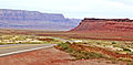
 Arizona Highway (9050557149).jpg 3,264 × 2,448; 2.36 MB
-
 Away from the Crowd, Navajo Nation, AZ 9-15 (21779702182).jpg 2,800 × 1,368; 1.51 MB
-
 Az coconino3.jpg 1,536 × 1,024; 508 KB
-
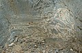 Breccia in Marble Canyon-750px.jpg 750 × 483; 75 KB
-
 Bruce, Mary and Brenda at Marble Canyon - Flickr - brewbooks.jpg 2,924 × 2,217; 3.72 MB
-
 Campground Nightscape, Marble Canyon, March 2015 - panoramio.jpg 2,271 × 3,406; 4.44 MB
-
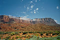
 Cathedral Rock and Vermillion Cliffs of Arizona.jpeg 1,576 × 855; 1.19 MB
-
 Cliff Dwellers Airport.jpg 768 × 768; 204 KB
-
 Column, Marble Canyon, September 2013 - panoramio.jpg 4,320 × 2,429; 3.51 MB
-
 Family Compound, Navajo Nation, AZ 9-15 (21628270258).jpg 2,800 × 1,635; 2.24 MB
-
 Gps-multipath-efect.png 600 × 386; 513 KB
-

-
 Marble Canyon Arizona With Vermilion Cliffs In Background.jpg 2,500 × 1,432; 2.51 MB
-
 Marble Canyon Arizona.jpg 2,000 × 1,131; 604 KB
-
 Marble Canyon Between Paria and Kaibito Plateaus, Arizona (6780632027).jpg 4,000 × 3,000; 5.37 MB
-
 Marble Canyon Between Paria and Kaibito Plateaus, Arizona (6780632791).jpg 4,000 × 3,000; 5.34 MB
-
 Marble Canyon International Airport (9052784596).jpg 2,590 × 1,730; 1.72 MB
-
 Marble Canyon, AZ. (37621255870).jpg 5,472 × 3,648; 8.67 MB
-
 Marble Canyon, Colorado River, Arizona (15397278543).jpg 4,000 × 3,000; 2.07 MB
-
 Marble Canyon, Colorado River, Arizona (16016214962).jpg 4,000 × 3,000; 2.1 MB
-
 Marble Canyon, United States (Unsplash).jpg 4,928 × 3,264; 1.02 MB
-
 Nankoweap-colorado.jpg 1,696 × 1,929; 836 KB
-
 Nature did this. (4707643845).jpg 2,376 × 1,581; 1.33 MB
-
 Navajo Bridge interpretive center in Marble Canyon, AZ.jpg 2,500 × 1,751; 1.09 MB
-

-
 Pohled ze silnice US 89 - panoramio.jpg 3,872 × 2,592; 3.29 MB
-
 Balanced Rocks, Marble Canyon, Arizona.jpg 4,928 × 3,264; 10.98 MB
-
 Vermilion Cliffs In Marble Canyon, Arizona.jpg 2,500 × 1,559; 2.27 MB
-
 Vermilion Road-Side, September 2013 - panoramio.jpg 4,320 × 2,038; 4.94 MB
-
 Vermillion Cliffs and Paria Plateau, Arizona (14017072530).jpg 4,000 × 3,000; 7.92 MB
-
 View of rolling clouds across Marble Canyon (38773902510).jpg 3,264 × 2,448; 2.04 MB
-
 View of rolling clouds across Marble Canyon (40584097111).jpg 3,264 × 2,448; 2.19 MB
-
 Červené skály v Marble Canyonu - panoramio.jpg 3,872 × 2,592; 3.27 MB
.jpg)

.jpg)
.jpg)
.jpg)


.jpg)


.jpg)
.jpg)
.jpg)
.jpg)
.jpg)
.jpg)
.jpg)

.jpg)

.png)


.jpg)
.jpg)
.jpg)
