Category:Maps showing 1685
Jump to navigation
Jump to search
| ← 1680 1683 1685 1687 1688 1689 |
English: Maps showing the year 1685 (i.e. history maps)
See also category: 1685 maps. and 1680s maps for more maps showing this year usually created not long after the given year.
See also category: 1685 maps. and 1680s maps for more maps showing this year usually created not long after the given year.
Media in category "Maps showing 1685"
The following 3 files are in this category, out of 3 total.
-
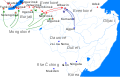 Dauria and Amur region 1685 cz.svg 1,985 × 1,281; 184 KB
-
 Edict of Fontainebleau - ar.svg 2,045 × 1,720; 7.84 MB
-
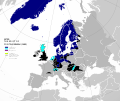 Edict of Fontainebleau.svg 2,045 × 1,720; 7.68 MB


