Category:Maps showing 1502
Jump to navigation
Jump to search
| 1500 1502 |
English: Maps showing the year 1502 (i.e. history maps)
See also category: 1502 maps. and 1500s maps for more maps showing this year usually created not long after the given year.
See also category: 1502 maps. and 1500s maps for more maps showing this year usually created not long after the given year.
Media in category "Maps showing 1502"
The following 6 files are in this category, out of 6 total.
-
 Christopher Columbus fourth voyage 1502-1504 map-fr.svg 1,922 × 1,256; 399 KB
-
 Columbus fourth voyage.jpg 1,001 × 630; 112 KB
-
 Crimea 1502 Ortho.svg 8,054 × 6,897; 763 KB
-
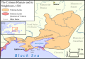 Crimean Khanate Map 1502.svg 414 × 285; 206 KB
-
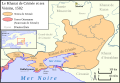 Khanat de crimée en 1502.svg 414 × 285; 207 KB
-
 Map 4thVoyage ChristopherColumbus 1502-4.svg 744 × 489; 734 KB


