Category:Maps of voivodeships of Poland 1946-1950
Jump to navigation
Jump to search
Subcategories
This category has the following 2 subcategories, out of 2 total.
Media in category "Maps of voivodeships of Poland 1946-1950"
The following 4 files are in this category, out of 4 total.
-
Administrative division of Poland (1946).svg 600 × 560; 112 KB
-
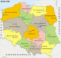
POLSKA 28-06-1946.png 701 × 667; 190 KB
-
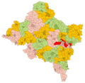
Silesian Voivodeship Administrative Map 1946-Zagłębie.png 1,390 × 1,726; 517 KB
-
Silesian Voivodeship Administrative Map 1946.png 6,013 × 5,884; 4.89 MB


